This exploration of our current day metropolitan condition as a system of systems deals with the crust of the Earth as a primary carrying capacitor of human activities, from the extraction of resources deep within the ground, to agricultural operations that barely scratch the surface.
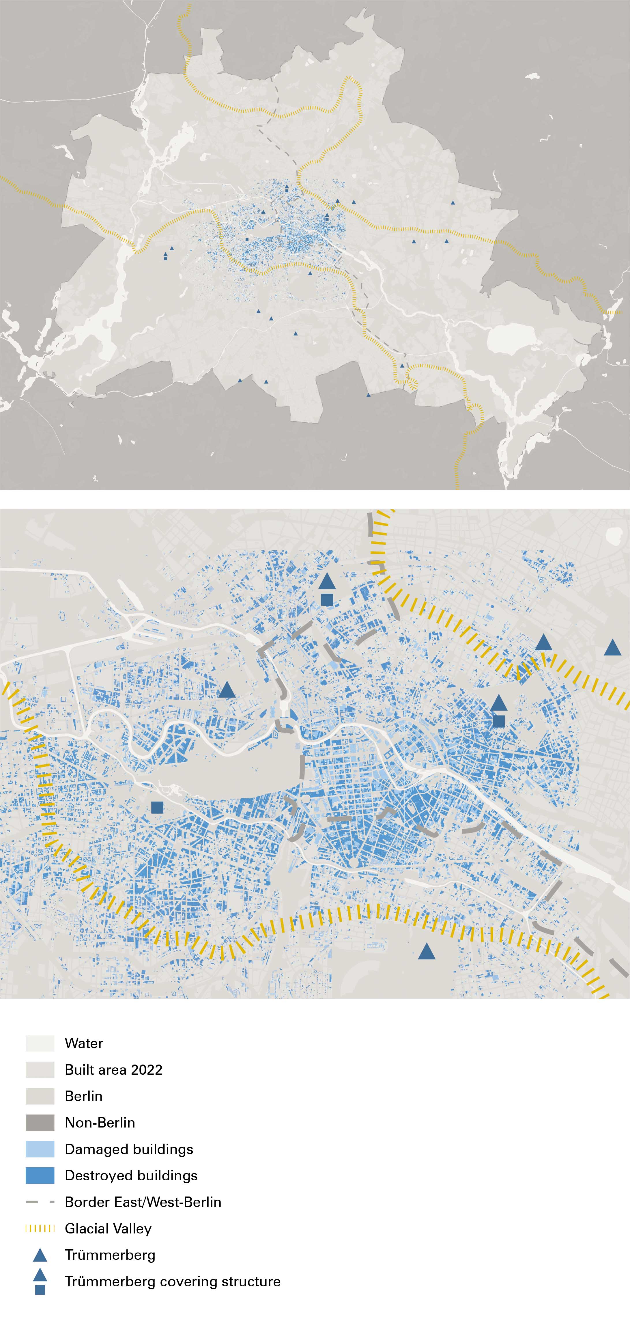
Trümmerberg, or Schuttberg, is the German word for ‘debris hill’, and specifically refers to the artificial hills that consist of urban rubble from the destruction of World War II. Several cities in Germany that were strategically bombed during the war, such as Berlin, Munich, and Stuttgart, have one or several of these hills in or around the city.
After the war, forty-six percent of the buildings in the central Berlin districts of Friedrichshain, Mitte, and Tiergarten, were totally destroyed or severely damaged. The removal of, in total, seventy-five million cubic meters of rubble began on the third of May, 1945.1 A temporary network of train tracks, called the Trümmerbahn, was laid out across Berlin in order to move the rubble to various locations specified by Reinhold Linger, director of the Office for Green Planning in Berlin. Gravel, sand, and clay extraction pits outside of the city would be ideal locations for rubble dumping. This was, however, not possible in West Berlin following its demarcation and physical separation from its surroundings, following the establishment of East Germany. Additionally, it was preferable to keep these rubble hills close to the destroyed places, so that less transportation time and infrastructure was needed. Instead of searching for and filling up natural depressions or green spaces, Lingner took the landscape conditions in consideration and planned a few big hills on the plateaus and edges of the regional glacial valley.
By covering the rubble with a layer of topsoil, the hills were greened. In addition to concealing the rubble of the war, three of these rubble hills physically cover Nazi buildings. The hills of Friedrichshain and Humboldthain cover two of the three anti-aircraft towers in the inner city that were too difficult to demolish. Furthermore, the biggest Trümmerberg, the Teufelsberg, covers the imcomplete Nazi Military Technical College designed by Albert Speer. The forested hills have now become part of the formerly flat topography of Berlin, hiding the remnants of the war within topographical vantage points. It seems only suitable that Anderson describes them as ‘geographies of forgetting’ and explains them as burial sites in order to make the city liveable again.2 But even though great effort has been put into forgetting, the hills have now become meaningful, monumental places within the city of Berlin. Take for instance the Großer Bunkerberg in Volkspark Friedrichshain, which hosts several monuments like the Japanese Peace Bell, and which became a source for inspiration for the band Silly, which produced the song Mont Klamott in 1983.
References 1.
Forßbohm, Ulrike. ‘Kriegs-End-Moränen - Zum Denkmalwert Der Trümmerberge in Berlin’. Technische Universität Berlin, 2009.
2.
Anderson, Benedict. Buried City - Unearthing Teufelsberg. Berlin and Its Geography of Forgetting. New York, NY: Routledge, 2017.