Project Global: Ground


This exploration of our current day metropolitan condition as a system of systems deals with the crust of the Earth as a primary carrying capacitor of human activities, from the extraction of resources deep within the ground, to agricultural operations that barely scratch the surface.

Part 1: Lexicon

Part 2: Atlas

Part 3: Architectural Projects


Part 1: Lexicon index

︎ Formation

    ︎ Kaapvaal Craton
    ︎ Johannesburg Dome
    ︎ Vredefort Dome
    ︎ Topsoil
    ︎ Müggelsee


︎ Measurement    ︎ Schwerbelastungskörper
    ︎ Mining Earthquakes
    ︎ Low-tech Soil Testing
    ︎ Soil Texture Triangle
    ︎ Geologic Time Scale 
    ︎ Stratigraphic Colum
    ︎ Geographic Information System
    ︎ Ecotone
    ︎ Cultural Landscape

︎ Prototype
    ︎ Unter den Linden
    ︎ Zoological Landscape
    ︎ Counterculture
    ︎ Cultural Agency
    ︎ Mine-pit Lakes
    ︎ Parliament of Things

︎ Land distribution
    ︎ 1913 Natives Land Act
    ︎ District Six
    ︎ Eavesdropping
    ︎ Reconciliation Policy
    ︎ Land Grabbing
    ︎ Land Acting
    ︎ The Red Ants
    ︎ #PutSouthAfricansFirst
    ︎ Suburban Enclaves
    ︎ Parallel State

︎ Extraction
    ︎ Cullinan Diamond Mine
    ︎ Platinum Group Metals
    ︎ Zamazamas
    ︎ Gold Rush Inertia
    ︎ Sinkhole
    ︎ Maize Doctor
    ︎ Coal Hands

︎ Infrastructure
    ︎ Gautrain
    ︎ Le-guba
    ︎ Lesotho Water Project
    ︎ Deutscher Wald
    ︎ Arrival City

︎ Production
    ︎ Safari Economy
    ︎ Agritourism
    ︎ Rainfall Line
    ︎ Upington Airport
    ︎ Tiergarten Transformation
    ︎ Pivot Irrigation
    ︎ Allotment Garden
    ︎ Bokoni Terracing
    ︎ Johannesburg Forestation
    ︎ Game Farming Cycle

︎ Waste
    ︎ Trümmerberg
    ︎ Fab-Soil
    ︎ Mining Waste Belt
    ︎ Sanitary Landfilling
    ︎ Soil Structure
    ︎ Biogas Technology

︎ Pollution
    ︎ Dry Stacked Tailings
    ︎ Water Pollution
    ︎ Soil Pollution
    ︎ Uranium Sandstorms
    ︎ Poaching

︎ Remediation
    ︎ European Green Belt
    ︎ Conservation Agriculture
    ︎ Airfield Urbanism
    ︎ Solar Park
    ︎ Gold Reef City
    ︎ Mine Pit Lake
    ︎ Loess Plateau
    ︎ Erosion Control


European Green Belt

“ — ”


The adjacent image that juxtaposes natural and man-made elements was taken in Bayern, from a physical section of the former border between East and West Germany. This former border now forms part of the European Green Belt, an ecological buffer zone in Europe.
        The European Green Belt initiative is a grassroots movement for nature conservation and sustainable development along the corridor of the former Iron Curtain. It connects national parks, nature parks, biosphere reserves, and transboundary protected areas, as well as non-protected valuable habitats along or across the former borders.
        In the forty years between the formation and fall of the former Iron Curtain, which ran from the Barents Sea to the Black Sea, severe restrictions with regards to access and land use had an unintended side effect of allowing nature along the border to develop almost undisturbed. The fact was observed as early as 1970, when satellite imagery depicted a dark green belt of old-growth forest on the Finnish-Russian border. In the early 1980s, nature conservationists observed many rare species within the restricted border area in between East and West Germany, when looking on with binoculars from the latter country.
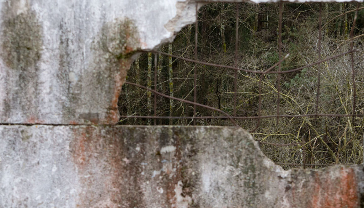


Image source: A Living Memorial, April 9, 2018
https://thehumancycles.com/author/tamzin/