Geographic Information System
“
How can we visualize and share the enormous amount of information we have about the face of the Earth?”
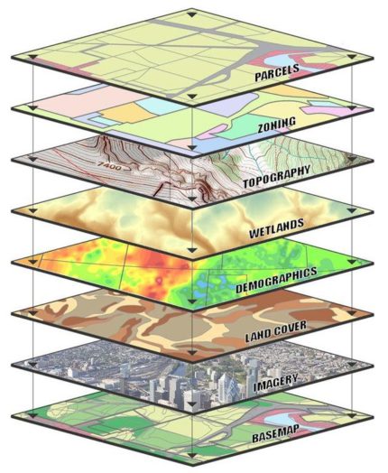
Geographic Information Systems, commonly referred to through the acronym GIS, is an open-source digital tool that creates, manages, analyzes, and maps-out data.1 It has become an open-portal instrument that improves collaboration across different fields, and allows for increased operational efficiency by visualizing real time information across all scales. GIS also allows for the collection and collation of time-lapse satellite photography, in order to understand the evolution of a site over time, and to improve natural resource management.
GIS technology uses geographic location as the index through which to overlay different forms of information, which are obtained through the use of satellites and their capacity for electromagnetic radiation that enables precise positioning on the Earth’s surface.
GIS technology is heavily used in earth science fields because of its versatility to visualize and overlay information such as land use, topography, agriculture, soil type, infrastructure, and vegetation, amongst many others at specific locations two and three-dimensionally. For instance, the department of Mining and Minerals Division can use GIS to survey potential mining sites and control current activity in order to mitigate environmental impact and ensu.2
![]()
Image source:
‘GIS and Remote Sensing | Plansup’. Accessed 19 March 2022. https://www.plansup.nl/expertise/gis-and-remote-sensing/.
References
1. Society, National Geographic. ‘GIS (Geographic Information System)’. National Geographic Society, 21 June 2017. http://www.nationalgeographic.org/encyclopedia/geographic
2. USC GIS Online. ‘The Application of Geographic Information Science in Earth Sciences’, 17 April 2021. https://gis.usc.edu/blog/the-application-of-geographic-and-information-science-gis-in-earth-sciences/.