Project Global: Ground


This exploration of our current day metropolitan condition as a system of systems deals with the crust of the Earth as a primary carrying capacitor of human activities, from the extraction of resources deep within the ground, to agricultural operations that barely scratch the surface.

Part 1: Lexicon

Part 2: Atlas

Part 3: Architectural Projects


Part 2: Atlas index

︎ Extraction
    ︎ Macro-economy
    ︎ Totems
    ︎ I. Gold
    ︎ II. Coal/Power   
    ︎ III. Water

    ︎ IV. Platinum
    ︎ Network

︎ Off-cycle
    ︎ Tailing Index
        ︎ Gold
        ︎ Platinum Group Metal
        ︎ Coal
        ︎ Chrome
        ︎ Vanadium
        ︎ Fluorite
        ︎ Diamond
    ︎ Mine Waste Landscape

    ︎ Case Study 1: Gold
    ︎ Case Study 2: Diamond
    ︎ Case Study 3: PMG
    ︎ Case Study 4: Fluorite
    ︎ Case Study 5: Coal

    ︎ Impact Air
    ︎ Impact: Ground
    ︎ Impact: Water


︎ Capacity
    ︎ Cashbuild for your backyarding needs!
    ︎ Material Proximity
    ︎ Township’s Evolution
    ︎ Townships’ Formation
    ︎ Nodes and Corridors
    ︎ Policy Resistance
    ︎ Township Renewal
    ︎ Infrastructure Density
    ︎ Regulated Infrastructure
    ︎ Pressure Points

    ︎ Shack Catalog

︎ Private Archipelagos
    ︎ Private Archipelagos
    ︎ Company Town
    ︎ Extended Networks
    ︎ Unstable Terrain
    ︎ Industrial Park
    ︎ Parallel Connections
    ︎ Industrial Pollution
    ︎ Planned City
    ︎ Commute Network
    ︎ On Site Resources
    ︎ Buffer Zone

    ︎ Informal Commerce

︎ Productive Land
    ︎ Exports vs Imports   
    ︎ Agricultural Land   
    ︎ Imports vs Exports
    ︎ Distribution
    ︎ Orchards
    ︎ Crops
    ︎ Livestock
    ︎ Game Farms
    ︎ Poultry
    ︎ Informal Trade


︎ Cultural Landscape

    ︎ Street Trees Distribution
    ︎ Golf Courses 1
    ︎ Game & Nature Reserves
    ︎ Trees Species Catalog
    ︎ Golf Courses 2
    ︎ Dinokeng Game Reserve 1
    ︎ Botanical Garden
    ︎ Jackal Creek Golf
    ︎ Dinokeng Game Reserve 2
    ︎ Herbarium
    ︎ Golf Courses 3
    ︎ Specificity


Policy Resistance

Alexandra


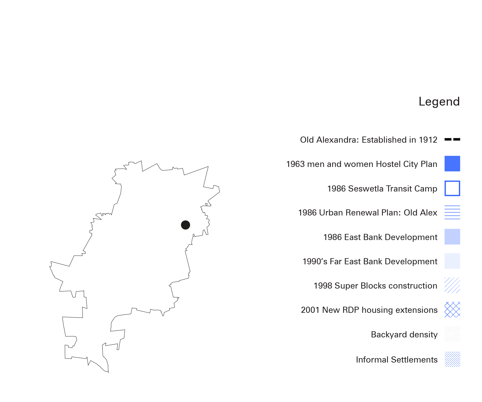
This map shows Alexandra’s various policies attempts for de-densification. Alexandra was founded in 1912 as a non-European settlement with free hold ownership. Since the 1930’s the population increased rapidly, creating a higly densified area. Due to its proximity to the inner city and high density Alexandra underwent a number of failed programs to either erradicate it, de-densify it or transform it. The first attempt was in 1963, when the government wanted to transform it into a single-sex hostel city. Only 3 hostels were built, 2 for men and 1 for women. In the 1980’s two more renewal plans failed due to the active relocations of informal and backyard dwellers outside of Alexandra. In 1986 Seswetla was established as a transit camp, however its settlers were never relocated and it became the largest informal settlement of the township. During this period the East Bank and Far East Bank started to develop but failed shortly after in 1990. However after 1994 they were retaken as part of the RDP housing program. In 1998 The Grater Alexandra Development Framework attempted to build super blocks in the Old town and the East Bank. In 2001 new RDP extensions were added to the Far East Bank as part of the Alexandra Renewal Plan.