Water
The second incarnation of the Project Global triptych investigates the water cycle—relevant as both input and output for the metropolitan metabolism. The thematic spans in terms of scale and lens: from geopolitical aspects to the individual human body, seeking to explore water as a crucial factor in the design of the built environment. Vienna served as an exemplar of a modern planned metropolis, related to water infrastructure and regulations. Mexico City, a city flooding and at the same time running out of water, formed the ground for interrogation.
In the summer of 2001, a group of scientists from Germany, Austria, Slovakia, Hungary, Yugoslavia, Bulgaria, and Romania boarded a fleet fully equipped with scientific apparatus and computers. Their goal was to perform a thorough investigation of the Danube Basin on chemical and biological water status in response to the EU’s new water directive. All the data and samples were collected under one uniform standard procedure and analyzed in one single laboratory, which eliminated the possibility of various data interpretation to its maximum, thus constructing a highly comparative database and a comprehensive understanding of the river. The survey had four indices: water quality, suspended solids, sediments and biological samples. Each of them was conducted multiple times in different segments of the Danube River to monitor urban, agricultural and industrial activities’ impact in real-time. Later, all samples were sent to the Austrian Research Center in Vienna for further analysis and archive.
The concept of regarding the Danube Basin as a collective water body across countries was first legislated in 1985’s Bucharest Declaration. So far (2020), ICPDR has formed four joint research teams as a part of a transnational monitoring network. More than merely scientific research, the result of the survey was published by the group and further served as guidelines for policy making that dedicate to maintain the ecological status of the surface water.
← Back to Lexicon
The research institution as a essential part of the trans-national water monitoring network.
Sources: ICPDR, Joint Danube Survey 1 - 2001, 2001, YouTube video screenshot.
Lake Neusiedl is an example of an endorheic basin in that it retains water and allows no outflow to other external bodies of water. The lack of outflow is from the basin’s floor dropping more rapidly than water and sediments can accumulate. At the center of each basin, the endorheic lake, is a collection of water or sink that has no evident outlet. Lake Neusiedl is the largest in central Europe. Endorheic basins’ watersheds are often confined by natural geologic land formations, such as mountains, that cut off water egress to the ocean or a large body of water. Endorheic basins, including Lake Neusiedl, typically have to be treated to be used for drinking water since their inland water flows into dry watersheds where the water evaporates. This process leaves a high concentration of minerals that causes the lake to become more saline over time.
In humid areas, the basins tend to be marshy. These areas, such as Mexico City, have endorheic basins that are subject to substantial flooding in wet years and characterized by waterlogged soils that require draining. In areas where rainfall is higher, erosion will generally carve drainage channels or cause the water level in the terminal lake to rise until it finds an outlet. In deserts, the water inflow is low and large amounts of water is lost from solar evaporation, reducing the formation of drainage systems. In extreme cases, the basin will become arheic.
With limited precipitation but high potential evaporation, water storage is vulnerable to subtle flux perturbations, such as Lake Neusiedl, which has dried up over a 100 times . For this reason basins have been drained by humans, temporary farmed, or their natural cycle has been converted to an artificially dominated nature‐social water cycle in order to control the basins. Today, Lake Neusiedl’s water level is controlled by an artificial outflow, the Einserkanal, and a sluice in Hungary by the Austro-Hungarian water commission. Minor fluctuations of the lake's level continue to occur making the equilibrium sensitive to climate change. There has been a recent decline in enhoreic water storage which is exacerbated by global warming and human activities.
Processes controlling the geochemical evolution of closed-basin lakes.
Sources: J.P Yan, M Hinderer, and G Einsele, “Geochemical Evolution of Closed-Basin Lakes: General Model and Application to Lakes Qinghai and Turkana,” Sedimentary Geology (Elsevier, October 23, 2001), https://www.sciencedirect.com/science/article/pii/S0037073801002123.
Sources: J.P Yan, M Hinderer, and G Einsele, “Geochemical Evolution of Closed-Basin Lakes: General Model and Application to Lakes Qinghai and Turkana,” Sedimentary Geology (Elsevier, October 23, 2001), https://www.sciencedirect.com/science/article/pii/S0037073801002123.
- Mary Guiden, “World's Largest Cities Depend on Evaporated Water from Surrounding Lands,” Colorado State University (Colorado State University, March 13, 2018),
-
Patrick W. Keys, Lan Wang-Erlandsson, and Line J. Gordon, “Megacity Precipitationsheds Reveal Tele-Connected Water Security Challenges,” PLOS ONE 13, no. 3 (2018), https://doi.org/10.1371/journal.pone.0194311.
-
G. Ragette , “The Evaporation of Rain and Snowfall in the Subcloud Layer,” Physics and Chemistry of the Earth, Part B: Hydrology, Oceans and Atmosphere 24, no. 6 (1999): pp. 619-622, https://doi.org/10.1016/s1464-1909(99)00054-4.
Lake Texcoco was a natural lake within the “Anahuac” or the Valley of Mexico. An indicator of human presence throughout history, the most prominent of the Mexican civilizations were formed around Lake Texcoco. It is believed that the lake disappeared and re-formed at least 10 times in the last 30,000 years.1 In order to control flooding, most of the lake was drained by the Spanish in the 17th century.
Tenochtitlán, in the heart of what is now Mexico City, was the largest altépetl and capital of the Aztec Empire. It was located on an artificial island in the middle of Lake Texcoco, a strange place for any capital, ancient or modern. On the outskirts of the lake stands an even older cultural complex, the ancient civilization of Teotihuacan, known for the most architecturally significant Mesoamerican. The later Aztecs of Tenochtitlán saw these magnificent ruins and claimed a common ancestry with the Teotihuacanos, modifying and adopting aspects of their culture.2
Nowadays, the area along with the Aztec’s massive canal systems are long drained. The only remnants of ancient Lake Texcoco have turned into a major tourist attraction around the area of Xochimilco, showcasing -among others- the ancient Mexican version of a polder system, through a network of flower-perfumed canals. The traditional chinampas (floating gardens) that once fed the great nation are smaller, but still here; the brightly painted trajineras (flat-bottomed boats) may now come equipped with engines, but they are still festively decorated, and many carry troupes of mariachis and offer relaxed "restaurant" service.3
Despite the drainage issues, water is still present around Lake Texcoco, bringing ancient cultures into life as the civilization of Teotihuacan is constantly revealed due to soil erosion by the high tides. Mexico City is a contemporary paradox: sinking and running out of water simultaneously. At the same time, the ancient lake is reclaiming parts of the scrapped airport in the greater region of Mexico City, leading the dream of restoring the landscape to its former glory.
← Back to Lexicon
Tenochtitlan, City of Aztecs in Ancient Mexico, in the middle of lake Texcoco.
- https://en.wikipedia.org/wiki/Lake_Texcoco
- https://en.wikipedia.org/wiki/Teotihuacan
-
https://www.viator.com/Mexico-City/d628
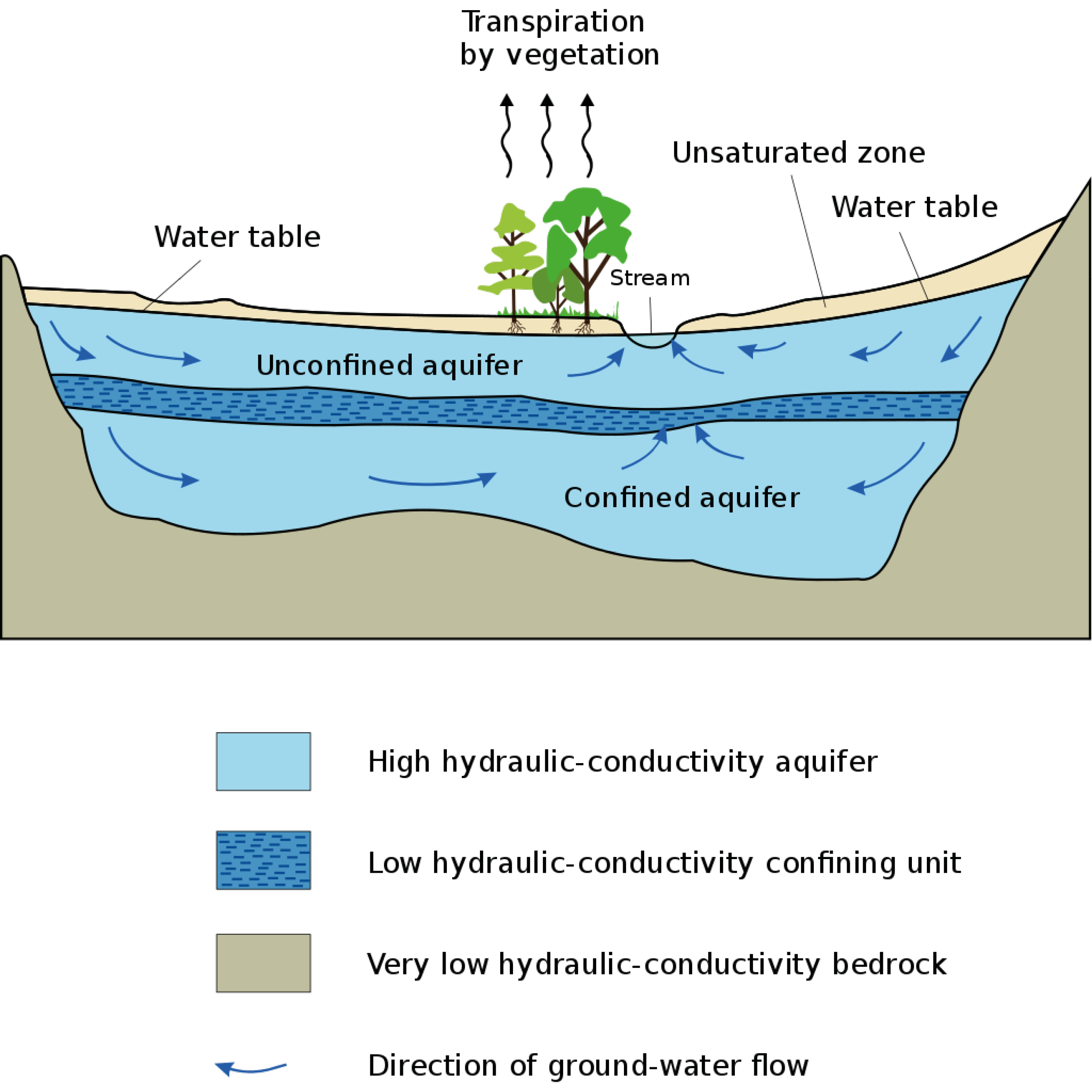
Marchfeld is an example of an aquifer in that it is a body of permeable rock can contain or transmit groundwater. The aquifer’s water movement depends on the permeability of the aquifer material. In some permeable materials, groundwater can move several meters in a day. In extreme cases, the water moves only a few centimeters in a century. Groundwater moves very slowly through relatively impermeable materials, such as clay and shale. If the groundwater is between layers of these impermeable materials, it is confined under pressure to become an artesian aquifer. An aquifer’s water, like Marchfelds, moves slowly towards lower lying places and is eventually discharged from springs, seeps into streams, or is withdrawn from the ground by wells.
97% of the earth's freshwater is stored in aquifers and groundwater is the primary source of drinking water for more than 1.5 billion people. Some of the largest cities in the developing world, such as Jakarta, Dhaka, Lima, and Mexico City, depend on aquifers for almost all their water. In rural areas, where centralized water supply systems are undeveloped, groundwater is typically the source of water.
The typical methods normally used to conceal garbage and other waste, such as landfills, septic tanks, and sewers, have become the major conduits of chemical pollution of groundwater. When aquifers are polluted, it is almost impossible to flush out contaminants from the clay layers where much of the aquifer’s water may be stored. With increases in urban population, the demand on groundwater is increasing and causing stress on the aquifers.
Many major aquifers are being drained faster than their natural rate of recharge. In some cases, areas like Marchfeld are being exploited at higher rates than previously done in the past. Marchfeld once provided water for agricultural uses but is now shifting to factory use. On average, a ton of water used in industry generates about 70 times as much profit as the same amount of water used to grow grain. Climate change has caused droughts in many aquifer areas. With the growing population and climate change, aquifers require heavy monitoring to keep the water level in balance.
Aquifer cross section.
Sources: “Aquifer,” Wikipedia (Wikimedia Foundation, April 23, 2021), https://en.wikipedia.org/wiki/Aquifer.
Sources: “Aquifer,” Wikipedia (Wikimedia Foundation, April 23, 2021), https://en.wikipedia.org/wiki/Aquifer.
- Thomas R Gatliffe, “Calibration and Reliability in Groundwater Modelling: Coping with Uncertainty,” Technometrics 44, no. 1 (2002): pp. 84-85, https://doi.org/10.1198/tech.2002.s655.
-
“Aquifers and Groundwater,” Aquifers and Groundwater, accessed March 3, 2021, https://www.usgs.gov/special-topic/water-science-school/science/aquifers-and-groundwater?qt-science_center_objects=0#qt-science_center_objects.
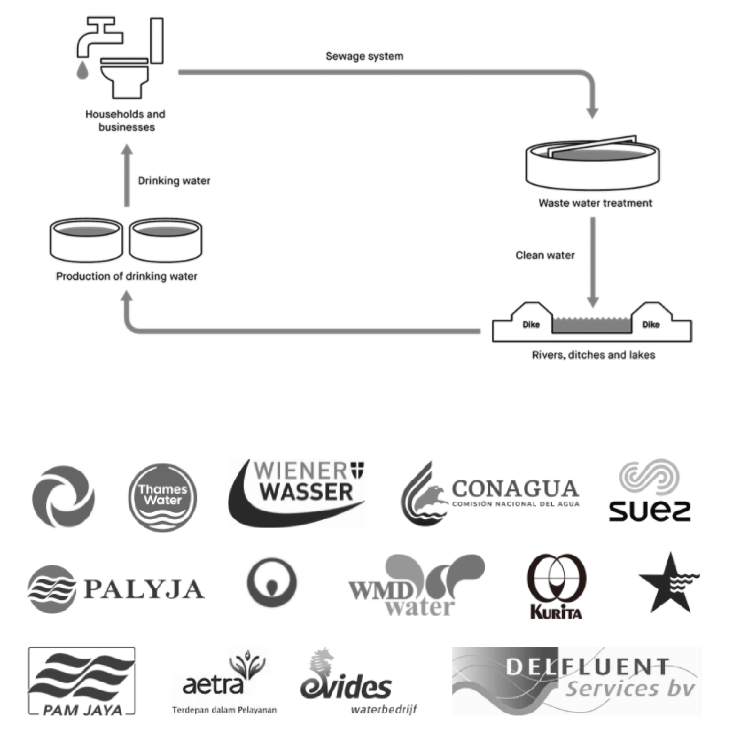
Drinking water company usually covers a part or whole water cycle of a city. In the case of Vienna, Wiener Wasser covers the whole water cycle with 100% spring water from the Lower Austrian-Styrian Alps. Wiener Wasser is a part of the municipal department in Vienna responsible for clean water supply, maintain and control the quality of the water and pipelines, manage public sewage systems, wastewater treatment, and education around drinking water.
Another public drinking company owned by the municipality such as Waternet in Amsterdam also covers similar responsibility to supply clean water and collection of wastewaters. While in another Dutch regions such as Delft, have Evides Waterbedrijf to manage their drinking water supply and Delfluent to manage sewers and wastewater treatment.
In London, a similar service is provided by a private drinking company called Thames Water. Thames Water is responsible for the public water supply and wastewater treatment in most of Greater London. The company has been through several takeovers by companies such as RWE (German utility company) and Kemble Water Holdings Ltd (Consortium).
Another type of drinking water service could be provided by the partnership between the public and private companies. For instance, Jakarta drinking water is being distributed by private companies in form of a 25-year concession agreement, in which both private companies (Palyja and Aetra) have to achieve universal service coverage and a reduction of water losses to 20 percent at the end of the concession period. (initially 46% and 61% respectively in 1998). Also, the municipality or government normally will have to buy all the shares from private companies at the end of the concession period.
In 2019, the Austrian Parliament passed a law enshrining the protection of drinking water resources in the Austrian constitution. Water privatization in Austria is thus henceforth unconstitutional.
← Back to Lexicon
Cycle of water diagram ; various logo of water company
Sources: Waternet. “Who We Are.” Wereld Waternet. Accessed May 2, 2021. https://www.wereldwaternet.nl/en/about-world-waternet/whoweare/.
- “Water Privatization.” Wikipedia. Wikimedia Foundation, March 12, 2021. https://en.wikipedia.org/wiki/Water_privatization.
- “Wiener Wasser.” zur Startseite der Stadt Wien, March 16, 2021. https://www.wien.gv.at/wienwasser/.
- Waternet. “Our Service Area.” Waternet. Accessed May 2, 2021. https://www.waternet.nl/en/about-us/our-service-area/.
- “Water Privatisation in Jakarta.” Wikipedia. Wikimedia Foundation, March 14, 2021. https://en.wikipedia.org/wiki/Water_privatisation_in_Jakarta.
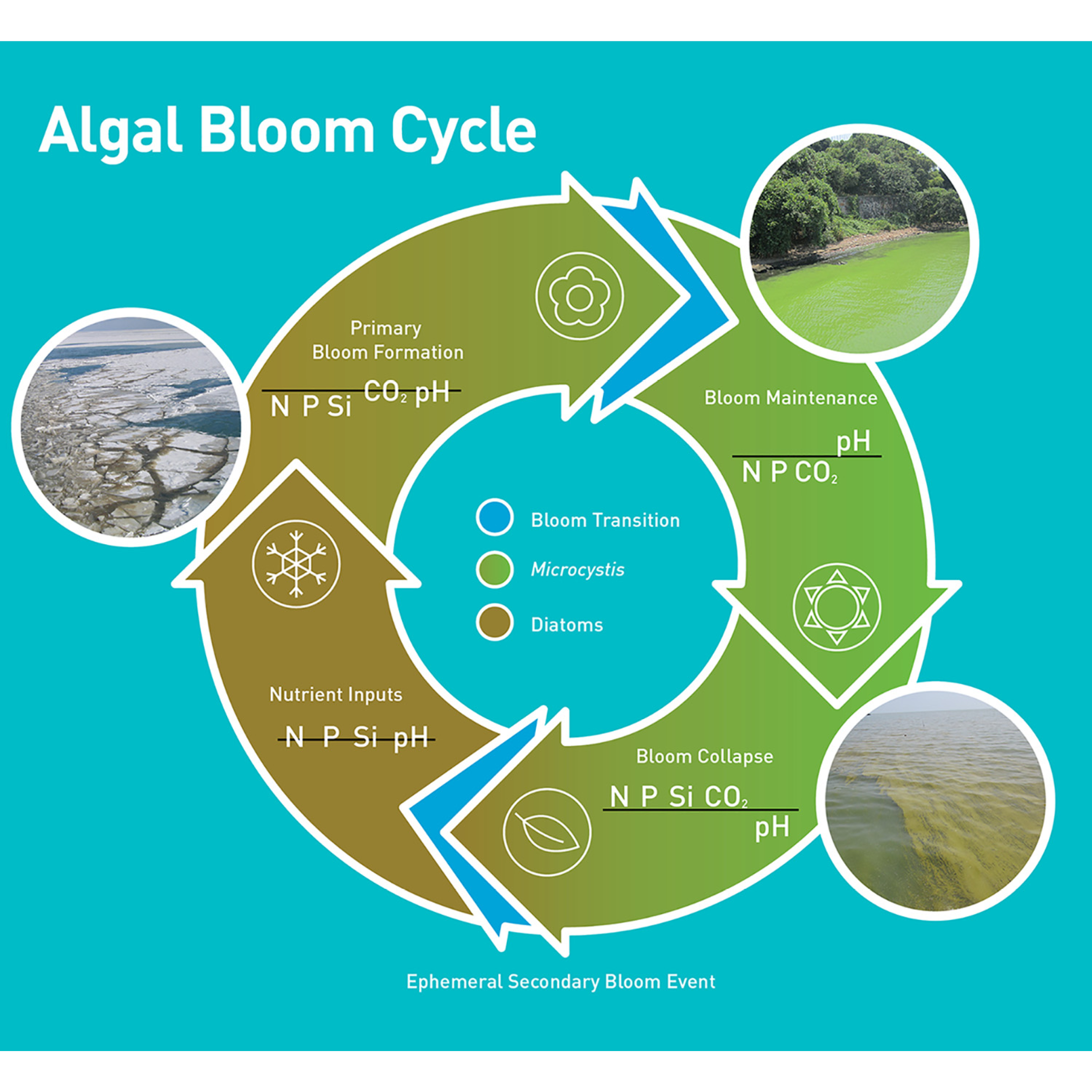
A phenomenon that occurs when due to human activities, a species has access to more nutrients than normal, causing a bloom in population. This leads to an imbalance in the ecosystem that is detrimental to other species.
The Algae Bloom, in particular, is one resulting from cultural eutrophication, where the two main contributors of minerals and nutrients into the water are raw sewage and agriculture. However, any usage including recreational use can contribute to this process and is one that has occurred historically. Eutrophication, most commonly the accumulation of phosphate and nitrate, occurs naturally and any human presence has meant the existence of cultural eutrophication. Say in the medieval era, the effects of this accumulation may have been no less than it is now, but a change did occur in that the effects are no longer localized and the Algae Blooms are being seen at a global scale. This is partially due to densification of population and industrial fertilizer use, however of note is the movement of nutrients in the form of food which also has a water amount attached in terms of production. Beyond the globalizing nature of agriculture, animal husbandry contributes to this process in the form of animal sewage along with any fertilizers used to produce any feed, most of which ends up in the water cycle.
As water tends to end up in the ocean, coastal and delta areas tend to be the most impacted by Algae Blooms, but areas with low water exchange like an Endorheic Basin are also particularly susceptible. Additionally, with the fracturing of the water cycle through dams, sewers, and globalized sources of phosphorus like the Kola Peninsula, the effects and contributions to Algae Blooms can reach far inland. However, cultural eutrophication in itself is a natural part of human existence and phenomenon such as the “Red Tide” are from extreme cases resulting from an incomplete biogeochemical water cycle.
← Back to Lexicon
Seasonal bloom cycle of a cyanobacteria, Microcystis, that is prevalent in freshwater
Sources: Wilhelm, Steven W., George S. Bullerjahn, and R. Michael L. McKay. "The Complicated and Confusing Ecology of Microcystis Blooms." mBio 11.3 (2020): e00529-20. Web. 03 May. 2021.
Sources: Wilhelm, Steven W., George S. Bullerjahn, and R. Michael L. McKay. "The Complicated and Confusing Ecology of Microcystis Blooms." mBio 11.3 (2020): e00529-20. Web. 03 May. 2021.
- Wassmann, Paul. (2005). Cultural eutrophication: perspectives and prospects. Drainage Basin Inputs and Eutrophication: An Integrated Approach.
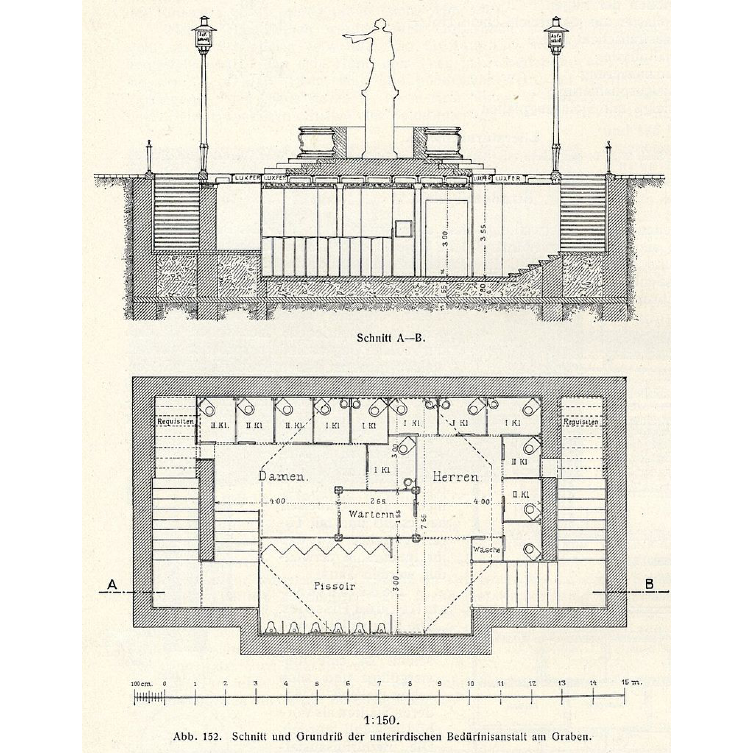
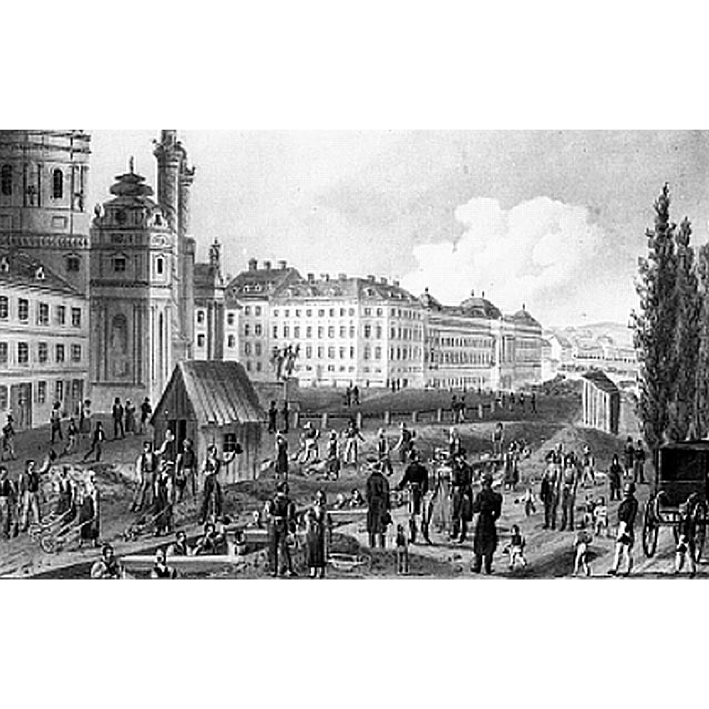
Vienna was subjected to a growing population by the mid-19th century and required better hygiene and public conveniences with the improved knowledge of diseases. The Vienna City Council founded the Urinal Commission in 1863 to install public toilet facilities throughout the city. Johann Gottlieb Wilhelm Beetz, a German-Austrian building contractor, offered a 25-year contract to the City of Vienna in 1880 to build public toilets modelled on the lavatories of Berlin. There were several protests by the population against building public toilets in the Ringstrasse, resistance by the Schottenstift- a Benedictine monastery, objections from the church authorities which limited the construction in several proposed locations. After several heated discussions and compromises, the proposal got accepted, and the Beetz company built seventy-three facilities in Vienna by 1910, and operated around 200 toilets and urinals till the 1930s.
The first model of toilets, also called Closet-Hauschen, were small wooden houses with cabins for men and women that soon turned out to be lucrative and were described as "practical, quite comfortable and luxuriously furnished". The municipality wanted public toilets to be camouflaged as street furniture, as a result of which, Beetz replaced wood with iron and glass in his design of the public lavatory on the Parkring; fashioning it in a Secessionist style and implementing the form of the waiting halls of the Viennese horse tramway. In 1904, Beetz built the first underground public toilet in Graben based on the architect Franz Krasny's plans in an attempt to make these toilets even more discreet. The underground structure of 14.5 × 7.7 meters with a height of 3 meters is the last existing public Art-Nouveau toilet in Vienna which can be accessed via two staircases with corresponding labels to separate the genders and adorned with two gas lanterns which doubled as ventilation chimneys. Beetz invented the oil siphon in 1883 where the metal urinal in toilets is coated in a special oil containing disinfectant, the 'urinol'. The use of urinol saved water flushing and kept the odours out, creating an early form of the dry urinal for which he received numerous well-deserved honours. In 1903, the City of Vienna decided to switch to these dry urinals to prevent damage in the water flushing systems during winters.
Vienna has always been immersed in art and culture, even in its most banal structures of public toilets built by Wilhelm Beetz listed as monuments, some of which are open for public use even today.
← Back to Lexicon
Drawings of the first underground public toilet in Graben next to the Josefsbrunnen.
Sources: “Öffentliche Bedürfnisanstalt am Graben”, Wikipedia, May 25, 2019, https://de.wikipedia.org/wiki/%C3%96ffentliche_Bed%C3%BCrfnisanstalt_am_Graben
- “Wilhelm Beetz (Bauunternehmer)”, Wikipedia, May 23, 2019, https://de.wikipedia.org/wiki/Wilhelm_Beetz_(Bauunternehmer)
- “Vienna at Your Convenience: A History of Public Toilets: Archives: The Vienna Review”, Archives | The Vienna Review, accessed May 03, 2021, https://www.theviennareview.at/archives/2012/vienna-at-your-convenience-a-history-of-public-toilets-2
-
“Toilets of Vienna: A Flush of Relief”, Metropole, November 20, 2019, https://metropole.at/toilets-of-vienna-a-flush-of-relief/
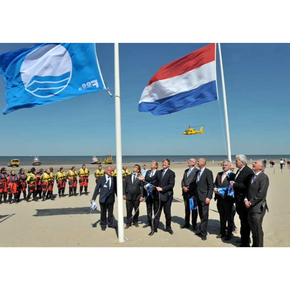
Blue Flag Award
![]()
“If you can't measure it, you can't improve it.” This was said by the theorist of business and management Peter Drucker. If the quality or quantity of something is not worth measuring and recording,what is the chance that it will be improved or cared about? Reflecting this statement, many campaigns now focus on measuring and recording values they care about. By simply measuring pollution, the number of cyclists or the variety of species on a peice of land, the case is made for why they are important and why the situation should be improved.
In parenting the sticker chart is a common tool for encouraging good behaviour in children. Mirco-rewards may cost little to give, but the result of giving them is valuable and reinforces positive behaviour. This technique of positive reinforcement does not just work on children.
The Blue Flag award is given to beaches and marinas that meet an extensive set of criteria related to quality, safety, environmental education, the provision of services and environmental management; for beaches there are almost 30 different criteria. Locations award it are widely recognised as being of excellent quality, and the award is well known by the public. The award was started in 1987 by the NGO, the Foundation for Environmental Education in Europe (FEEE). Due to global interest, in 2001 the foundation dropped its association to only Europe and became FEE. The foundation is funded by its membership of state governments. In 2015, 4,154 blue flags were flying at beaches, marinas and tourism businesses. The top five nations with blue flags were Spain, Turkey, Greece, France and Italy, all countries with valuable beach tourism industries. Whilst the award can be seen as a micro-reward like the child’s sticker chart, as it has no financial prize attached to it, it is a valuable tool in branding resorts and encouraging tourism and is thereby sought after.
Whilst many understand the blue flag to be a mark of quality and high environmental standards, few would know the extensiveness of the criteria. This may not be a bad thing, if the criteria are robustly written it can lead to wide benefits beyond those assumed by visitors. However if a lack of a blue flag is then taken to be a sign of poor quality this could be problematic. A beautiful, remote beach may have the highest environmental standards and excellent conditions, but due to a lack of other infrastructure such as a beach map, disabled toilet facilities or easy access, the beach would not qualify for the award. It may even be that some locations would qualify, but the administration simply has not happened. If these locations’ lack of blue flags was taken as a negative judgement of them, this would paint a false picture.
← Back to Lexicon
King Willem-Alexander raising the blue flag
Sources: The Foundation for Environmental Education
Sources: The Foundation for Environmental Education
The river has been a source of food since prehistory. They are often a rich source of fish and other edible aquatic life and are a major source of freshwater. The river also provides an easy means of disposing wastewater and other waste. For this reason, human settlement often flourishing in the riverbank area for the convenience of water resources, which led the river to be polluted and became a place associated with an unsanitary condition.
During the industrial revolution, some rivers are heavily polluted from factories, overpopulation, and lack of sanitation. These rivers were then covered with concrete to hide the deteriorating condition of the river and seen as the success of industrialization and modernization of the urban environment.
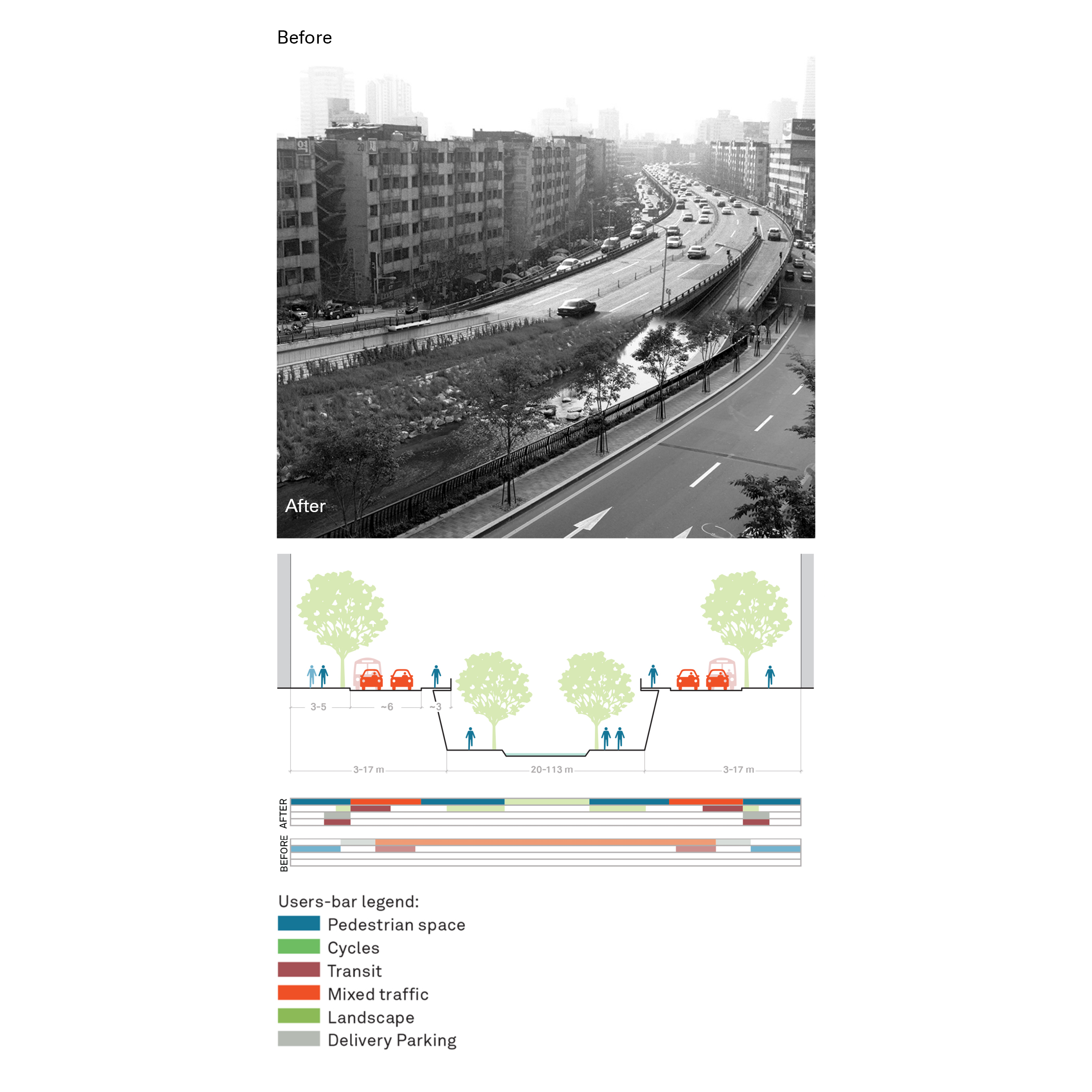
Nowadays, these concrete piped have become a grey space of concrete jungle, which usually used to provide service network for the city, such as road, clean water, sewers, or others. One of the attempts to revitalize this grey space was made by several cities by reverse the process of the piped stream and open the river stream again, called daylighting. Daylighting could bring ecological, economic, and/or socio-cultural wellbeing to the city and its inhabitants, e.g., Restoration of the Cheonggyecheon River in Seoul.
Another example of revitalizing piped stream water is the Ecoducto Linear Park in Mexico City, which aims to show that piped rivers can be reintegrated into the urban water cycle. The linear park runs the length of 1,600 linear meters giving life to new flora, gardens, and fauna. In addition, the project incorporates sludge beds, biodigesters, and water treatment systems, which make it not only an aesthetic element for the city but also a water purifier that gives life to its surroundings.
← Back to Lexicon
Cheonggyecheon restoration project traffic evaluation
Sources: “ Case Study: Cheonggyecheon; Seoul, Korea.” Global Designing Cities Initiative. Accessed May 2, 2021. https://globaldesigningcities.org/publication/global-street-design-guide/streets/special-conditions/elevated-structure-removal/case-study-cheonggyecheon-seoul-korea/.
Sources: “ Case Study: Cheonggyecheon; Seoul, Korea.” Global Designing Cities Initiative. Accessed May 2, 2021. https://globaldesigningcities.org/publication/global-street-design-guide/streets/special-conditions/elevated-structure-removal/case-study-cheonggyecheon-seoul-korea/.
- Daylighting (Streams). Wikipedia. Wikimedia Foundation, April 5, 2021. https://en.wikipedia.org/wiki/Daylighting_(streams).
- Apaloosa Estudio de Arquitectura y Diseño, Simetría Estudio de Arquitectura, and Giancarlo Reyes Olguin. Linear Park Ecoducto: Water as a Constructive Material. urbanNext, October 4, 2019. https://urbannext.net/linear-park-ecoducto/.
- River. Wikipedia. Wikimedia Foundation, May 1, 2021. https://en.wikipedia.org/wiki/River.
- Pollution during the Industrial Revolution. Foundations of Western Culture. Accessed May 2, 2021. https://foundations.uwgb.org/industrial-pollution/.
- Cheonggyecheon. Wikipedia. Wikimedia Foundation, March 21, 2021. https://en.wikipedia.org/wiki/Cheonggyecheon.
Drain-Jet Robotics
![]()
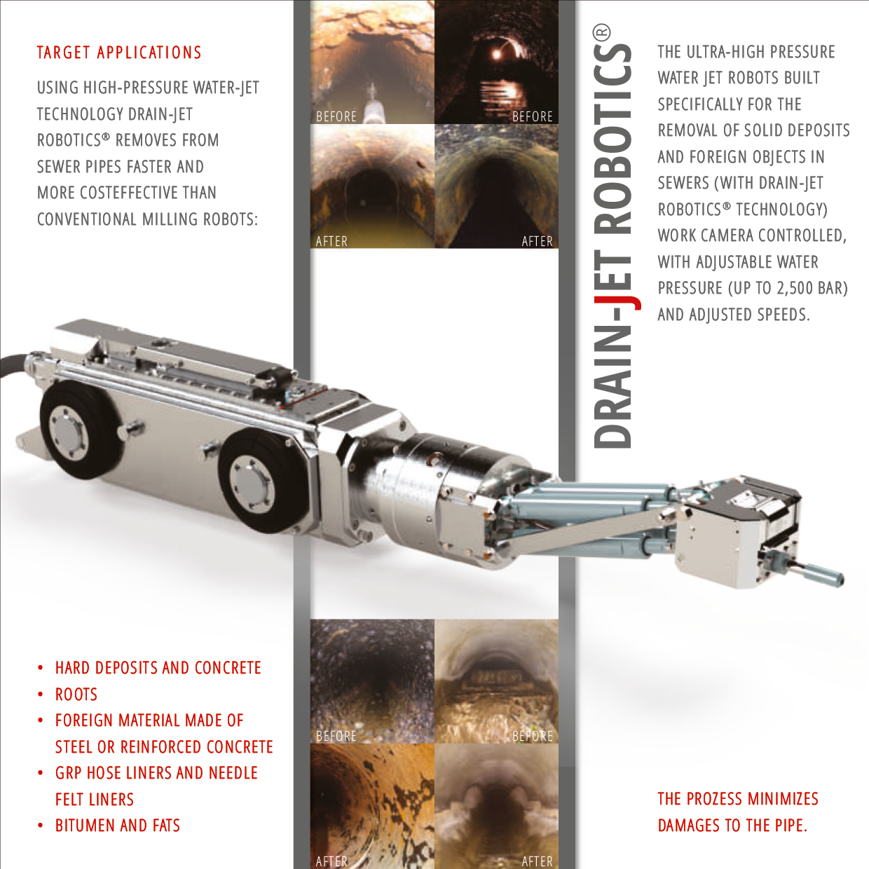
Urban services are unnoticeable elements of the city unlike new buildings and suburbs development. The sewer municipal system requires constant maintenance to avoid errors and breakages. Being underground it was always a technical question how to clean and repair sewer canals and pipes.
The very first inventions were applied to the Paris sewer system. The Flushing boat was used to move through sewers for manually control and cleaning. The Pills Balls, that were supposed to push and velocity sewer flows, were produced in different sizes as a technical answer for the unreached places of uniform tunnels.The next step in advancing maintenance was self-powered (by engine) equipment that allowed workers to operate overground.1 The further technical improvement, aimed to take workers from manual cleaning and repairing to remote controlling of equipment, came to robotization tools in the end through the automatization and computerization.
Drain-Jet Robotics has high-pressure water serves for cleaning and preparing tunnels and sewer pipelines for their repairs. The video camera allows you to monitor a sewer surface and control a robot in real time, while the data and track recording helps to monitor the sewer tunnels and work operatively and locally. The spot approach of control helps to avoid massive earthworks and optimizes time and resources on fixing breakages and deterioration. Thus Drain-Jet Robotics became a constructor with all additional parts and equipment and a car control room turned into a computer program with navigating robots in a sewer labirint, that is how the real work process of maintaining has turned from tough cleaning to an exciting game.
For proper maintenance sewer lines should be cleaned at least once a year. One Robot with two workers can clean up to 16 Tons KG , from 45 to 100 meters of tunnel in one cleaning session.2 Thus, to clean the municipal sewer system like in Vienna (2400 km), it required 68 robots and 136 workers with everyday cleaning.
← Back to Lexicon
Drain-Jet Robotics advertisement brochure shows one of the latest version of technical cleaning equipment
Sources: https://www.mauerspecht.de/drain-jet-robotics-en.html
Sources: https://www.mauerspecht.de/drain-jet-robotics-en.html
- http://www.sewerhistory.org/photosgraphics/maintenance-sewer-cleaning-equipment/
- https://www.sewerrobotics.com/en/sewer-pipeline-cleaning-and-obstruction-removal/global-pipe-cleaning-and-obstructions-removal-case-studies
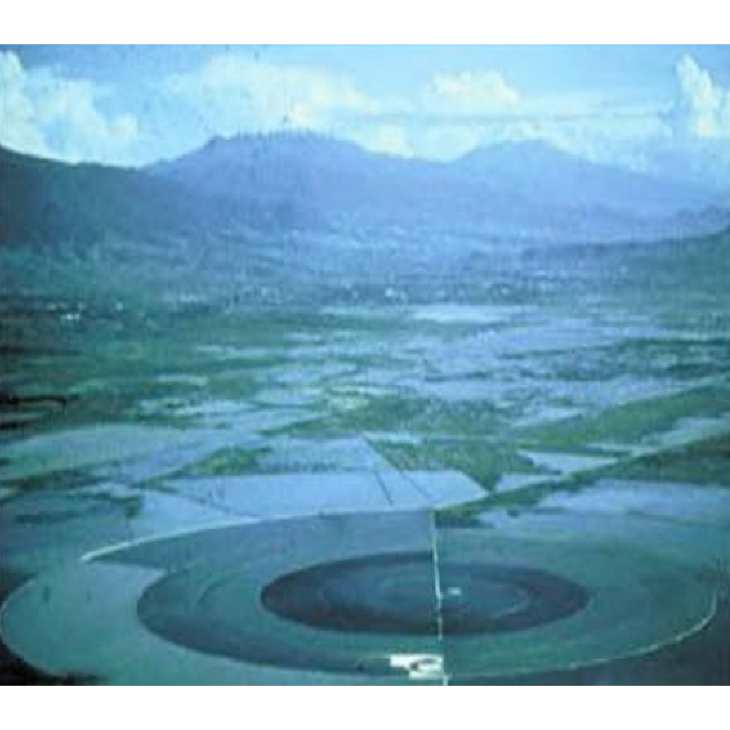
Caracol Ecatepec was built in 1942 by SOSA Texcoco to desalinate the water of Lake Texcoco. Designed by Nabor Carrillo, the retention basin and a desalination plant were located over the drained site of Lake Texcoco.1 The 3,200m in diameter basin was called “the snail” from its short spiral-shaped concrete levee that circles it.1 The water from the lake entered from a pump house on an island in the middle of the basin and was channeled outward and clockwise.1 The channel increases in width while decreases in depth until it becomes too shallow to flow further.1 The water evaporates in the opposite direction.1 This allowed for a predictable collection of 100 tons of salts per day.1 The desalinated water that was extracted was used by the factories nearby.
A lack of understanding of the actual process caused the process to be more expensive than expected. In 1967, Lake Texcoco was further exploited by discovering and cultivating its blue algae. The algae are collected by screens and processed into dry nutritional supplement powder for commercial sale branded "Spirulina Mexicana". In December 1986, SOSA Texcoco went bankrupt from a series of strikes and the slow hand labor forced by its snail shape. In 1991, the company and facilities were sold at a low rate to a collective of investors called Sociedad Anónima de Capital Variable. Sociedad Anónima de Capital Variable tried to negotiate the collective bargaining contracts for manual laborers that were mandated upon SOSA Texcoco by the Madrid administration. In 1991, the Mexican Supreme Court ruled that the old contracts must be honored if any profit-seeking business were to resume operations. This forced Sociedad Anónima de Capital Variableto to fold. The government then liquidated the original deed, voided the worker contracts, and seized the inactive facility as a public asset.
In 2000, Caracol was redeveloped with 13,000 new units of low-income housing and a shopping mall. With the additional development and the informal growing settlement of El Salado nearby, the basin cannot expand.The basin is currently owned by the Mexican government and in use as a reservoir for industrial facilities within Mexico City. It is filled from a junction with the Canal de Sal that runs along the south edge of the facility and connects it to the rest of the Mexico City drainage basin.
← Back to Lexicon
El Caracol in mid-20th century.
Sources: Imen Hamed, “The Evolution and Versatility of Microalgal Biotechnology: A Review,” Wiley Online Library (John Wiley & Sons, Ltd, September 26, 2016), https://onlinelibrary.wiley.com/doi/full/10.1111/1541-4337.12227.
Sources: Imen Hamed, “The Evolution and Versatility of Microalgal Biotechnology: A Review,” Wiley Online Library (John Wiley & Sons, Ltd, September 26, 2016), https://onlinelibrary.wiley.com/doi/full/10.1111/1541-4337.12227.
- Jose Castillo, “Peripheral Landscapes, El Caracol, Mexico City,” Architectural Design 78, no. 1 (2008): pp. 64-67, https://doi.org/10.1002/ad.611.
-
“El Caracol, Ecatepec,” Wikipedia (Wikimedia Foundation, April 10, 2020), https://en.wikipedia.org/wiki/El_Caracol,_Ecatepec.
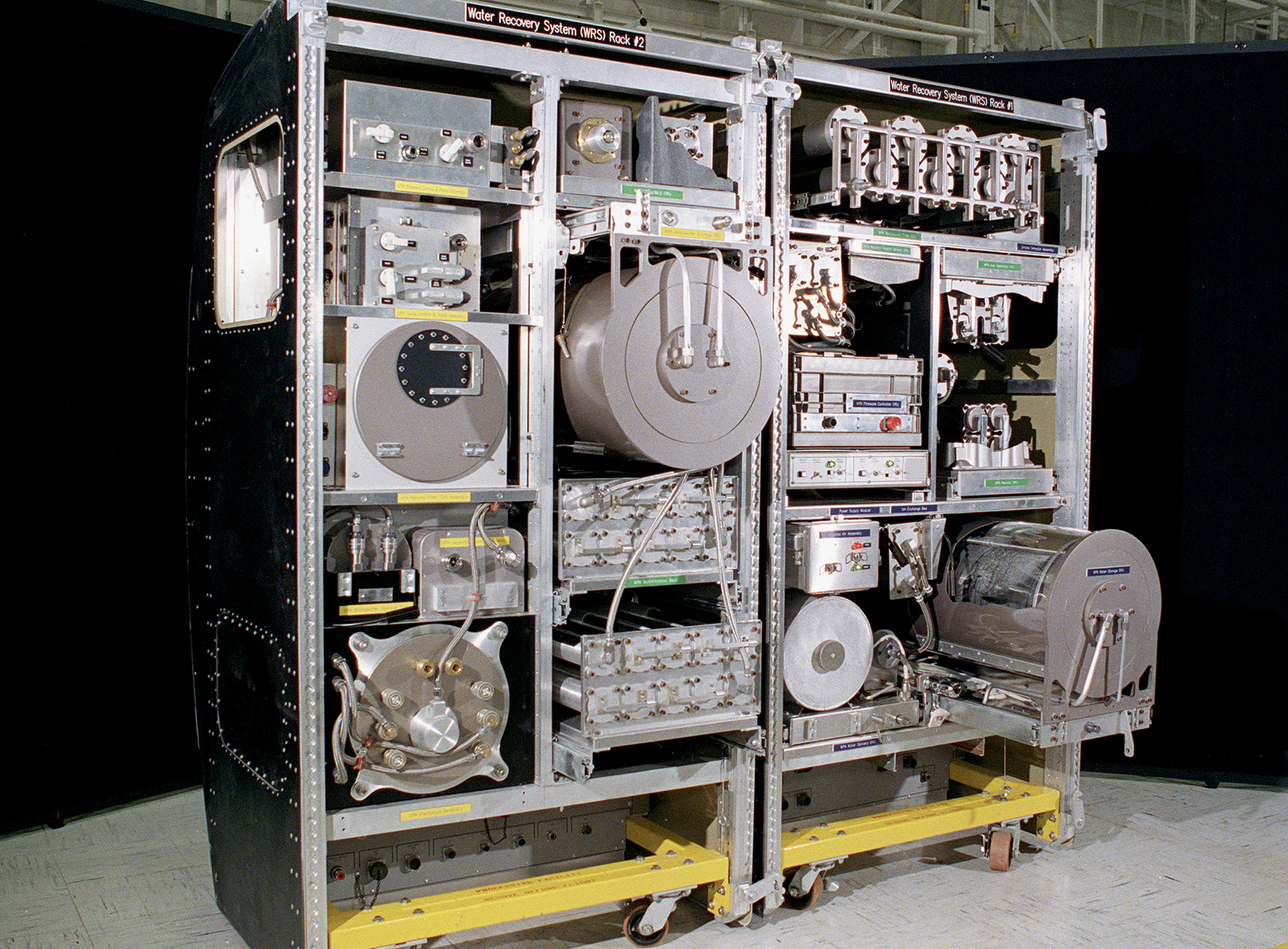
‘On Earth, distilling is a simple process of boiling water and cooling the steam back into pure water.' In space however, the extreme conditions make it more challenging to provide astronauts with safe drinking water. On the International Space Station (ISS), ‘[a] keg-sized distiller spins to produce an artificial gravity field while boiling the water. The contaminants in the urine or greywater press against the sides of the drum while the steam gathers in the middle and is pumped to a filter.’
‘Product water from the Urine Processor is combined with all other wastewaters and delivered to the Water Processor for treatment. The Water Processor removes free gas and solid materials such as hair and lint [and minerals such as calcium sulfate, due to loss of bone mass in zero-gravity], before the water goes through a series of multifiltration beds for further purification. Any remaining organic contaminants and microorganisms are removed by a high-temperature catalytic reactor assembly. The purity of product water is checked by electrical conductivity sensors (the conductivity of water is increased by the presence of typical contaminants). Unacceptable water is reprocessed, and clean water is sent to a storage tank, ready for use by the crew.’ At the end of the process, around 70% of all water content can be recovered.
← Back to Lexicon
Drinking waste water in space
Sources: NASA. Water recycling system on ISS
Sources: NASA. Water recycling system on ISS

In the control room there is access to the monitoring of the 3,000 kilometers of the municipal water supply infrastructure with the plants and power stations. All parameters can be modified and changed through computerized technology with all necessary technical equipment on different points of the Vienna water and sewer networks.
This technical improvement and upgrade was done according to Water 4.0 strategy. One of the main control parameters is water pollution. The implementation of Water 4.0 technology helps to divide different sewer and storm water flows to optimise the work of sewage treatment plants and the level of drainage.1
The control is implemented with Siemens technology Sinaut ST-7 telecontrol system and the proven Simatic S7-300 controls, the Scada system WinCC OA.2 Kilometers of data cables connects sub-centers in one system, kind of the nervous system of the city that gives and transmit impulses.
The soft support is provided by European Digital Services EDS 4.0 GmbH. It is a private company in Germany that cooperate with municipalities of different cities, espatial Vienna by supplying the technology "Gemeindepaket". They link all urban services through the one date-base platform that digitise and then simplify and optimize administrative tasks and resources.
The concept of Smart City is the integration work and control of different kinds of city infrastructures in real time with possible future prediction and adaptation to changing needs. According to the global smart city index, Singapore, Helsinki and Zurich are the top cities in economical and technological data.3 The importance of optimization of city infrastructures was shown during the Covid-19 era, quick response in extreme situations helps to overcome the economic crisis.
← Back to Lexicon
Chernobyl controlroom, Randstad control room for gas and electricity, Nasa control room, Control room of water infrastructure of Vienna under the Water 4.0 strategy
Sources:
https://press.siemens.com/global/en/news/ifat-2018-hall-a1-booth-439-water-40-new-control-center-vienna-water
Sources:
https://press.siemens.com/global/en/news/ifat-2018-hall-a1-booth-439-water-40-new-control-center-vienna-water
- https://germanwaterpartnership.de/wp-content/uploads/2019/05/GWP_Brochure_Water_4.0.pdf
- https://press.siemens.com/global/en/news/ifat-2018-hall-a1-booth-439-water-40-new-control-center-vienna-water
- https://www.imd.org/smart-city-observatory/smart-city-index/
During the last 150 years, the Danube river in Vienna was reformed by extensive flood-control engineering. The Vienna Danube Regulation describes all the necessary actions to prevent and control flooding.
The first official proposal for regulating the Danube river by the formation of a new river bed, was in 1810 by Josef von Shemerl after recurring severe flooding. However it was never realized. Between 1870 and 1875 the first major dams or levees were built in today’s municipal districts of Florisdorf and Donaustadt, on the left bank of the river, separating from the old river bed, the Old Danube. Between 1972 and 1988, a new channel, the New Danube, created and the material that occurred from its excavation, formed the Danube Island.
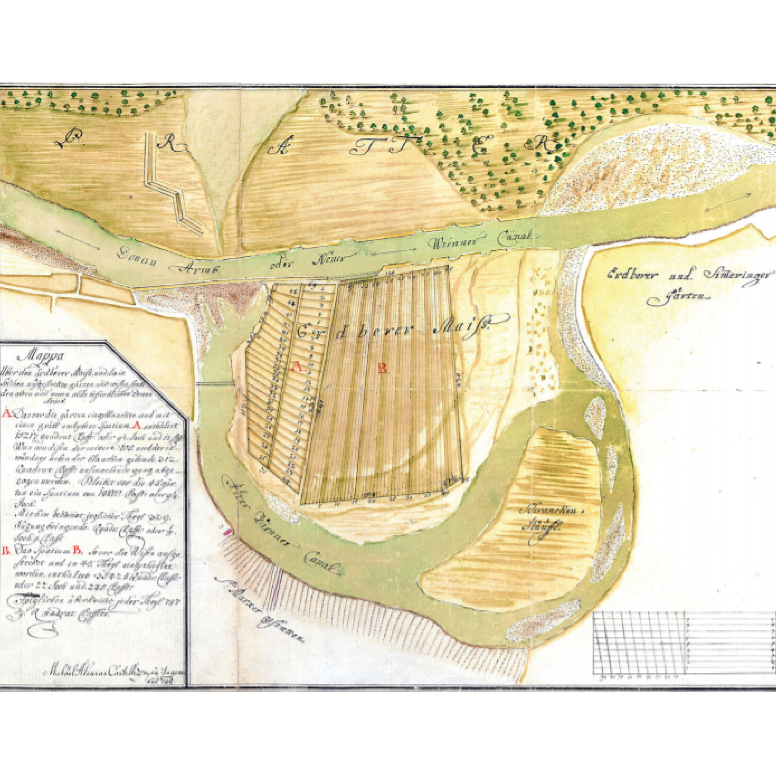
Nevertheless, the unrecorded origins of Donau Regulerum, are found a century earlier in the largest meander loop of Donau Kanal. Erdberger Mais, an area located southeast of Vienna, was formed by the dynamics of Danube, but also by the local regulations on the river landscape. Around 1715, a minor loop was cut off and straighten by means of a puncture, because it was threatening to erode part of the Prater Main Alley by breaking through to the main arm of Danube. In 1926, the large meander around the Mais was cut and dammed, by Emperor Karl VI orders. The design of the dam would allow the floods once per year, by depositing the fine sediments into the old river and protecting the oxbow lake.
The particular land reclamation was one of the earliest hydraulic engineering breakthroughs. The alluvial land, with its nutrient-rich and sandy soils, was well suited for agriculture activities and in particular for planting vegetables and herb gardens. By 1740 the land was parcelled and distributed to vegetable farmers.
Roughly 100 years after its creation, Erdberger Mais, “accounted for about 20 % of acreage for vegetable production in the city and its close environs”, playing a vital role in the city’s food supply. The specific land use and the configuration of the parcels to maintain the land arable, preserved the topographical characteristics. However, after WWII the land was massively transformed, erasing the remains of its hydraulic past.
← Back to Lexicon
The first official proposal for regulating the Danube river by the formation of a new river bed, was in 1810 by Josef von Shemerl after recurring severe flooding. However it was never realized. Between 1870 and 1875 the first major dams or levees were built in today’s municipal districts of Florisdorf and Donaustadt, on the left bank of the river, separating from the old river bed, the Old Danube. Between 1972 and 1988, a new channel, the New Danube, created and the material that occurred from its excavation, formed the Danube Island.
Nevertheless, the unrecorded origins of Donau Regulerum, are found a century earlier in the largest meander loop of Donau Kanal. Erdberger Mais, an area located southeast of Vienna, was formed by the dynamics of Danube, but also by the local regulations on the river landscape. Around 1715, a minor loop was cut off and straighten by means of a puncture, because it was threatening to erode part of the Prater Main Alley by breaking through to the main arm of Danube. In 1926, the large meander around the Mais was cut and dammed, by Emperor Karl VI orders. The design of the dam would allow the floods once per year, by depositing the fine sediments into the old river and protecting the oxbow lake.
The particular land reclamation was one of the earliest hydraulic engineering breakthroughs. The alluvial land, with its nutrient-rich and sandy soils, was well suited for agriculture activities and in particular for planting vegetables and herb gardens. By 1740 the land was parcelled and distributed to vegetable farmers.
Roughly 100 years after its creation, Erdberger Mais, “accounted for about 20 % of acreage for vegetable production in the city and its close environs”, playing a vital role in the city’s food supply. The specific land use and the configuration of the parcels to maintain the land arable, preserved the topographical characteristics. However, after WWII the land was massively transformed, erasing the remains of its hydraulic past.
← Back to Lexicon
A map of Erdberger Mais in 1748 illustrating the parcels of land in the effort to make it arable and the first cut-off of Donau river.
Sources: WStLA, Kartographische Sammlung, P1.42: ‘‘Mappa u¨ber den Erdberger Mais und die in Solchen ausgesteckte ga¨rten und wisen, sambt den alten und neuen alda befindlichen Donau Armbs’’, 1748
Sources: WStLA, Kartographische Sammlung, P1.42: ‘‘Mappa u¨ber den Erdberger Mais und die in Solchen ausgesteckte ga¨rten und wisen, sambt den alten und neuen alda befindlichen Donau Armbs’’, 1748
“I’m planning something geographical.”
When the baron introduced his rubber kingdom to Fitzcarraldo, he pointed at a trapezial area on the map hanging on the wall. The map - no bigger than a portrait - marked the territory between two tributaries of the Amazon with thin black lines as guidance and coordinates, seemingly insignificant and harmless. Nevertheless, it was one of the most powerful tools for humans to conquer the unknown and turn natural resources into capitals, which without a doubt, still is nowadays. Humans, through the process of surveying, position oneself in relation with the terrain. From rope stretchers to optical theodolites, Yu Ji Tu1 in ancient China to the section method in the US, the apparatus and methods of surveying evolved, while the purpose remains the same - requirement for the management, acquisition, and disposal of land.2
Waters in human society thus have been transformed into information. Such a process first breaks down water bodies into fragments of figures, samples, and sections for objects from different locations can be measured and recorded. Surveyors then construct these pieces of information together to comprehend the water as an autonomous system or part of a system. Finally, to gain control of it, information needs to be abstracted and reduced again, as Latour mentioned in Paris Ville Invisible, through an oblig-opticon lens.3
The story of Fitzcarraldo is the ravings of a madman’s dream, where nature is filled with fornication and asphyxiation, harmonizing in overwhelming and collective murder4 that through transformed information can one retain ration.
← Back to Lexicon
---Brian Sweeney "Fitzcarraldo" Fitzgerald
When the baron introduced his rubber kingdom to Fitzcarraldo, he pointed at a trapezial area on the map hanging on the wall. The map - no bigger than a portrait - marked the territory between two tributaries of the Amazon with thin black lines as guidance and coordinates, seemingly insignificant and harmless. Nevertheless, it was one of the most powerful tools for humans to conquer the unknown and turn natural resources into capitals, which without a doubt, still is nowadays. Humans, through the process of surveying, position oneself in relation with the terrain. From rope stretchers to optical theodolites, Yu Ji Tu1 in ancient China to the section method in the US, the apparatus and methods of surveying evolved, while the purpose remains the same - requirement for the management, acquisition, and disposal of land.2
Waters in human society thus have been transformed into information. Such a process first breaks down water bodies into fragments of figures, samples, and sections for objects from different locations can be measured and recorded. Surveyors then construct these pieces of information together to comprehend the water as an autonomous system or part of a system. Finally, to gain control of it, information needs to be abstracted and reduced again, as Latour mentioned in Paris Ville Invisible, through an oblig-opticon lens.3
The story of Fitzcarraldo is the ravings of a madman’s dream, where nature is filled with fornication and asphyxiation, harmonizing in overwhelming and collective murder4 that through transformed information can one retain ration.
← Back to Lexicon
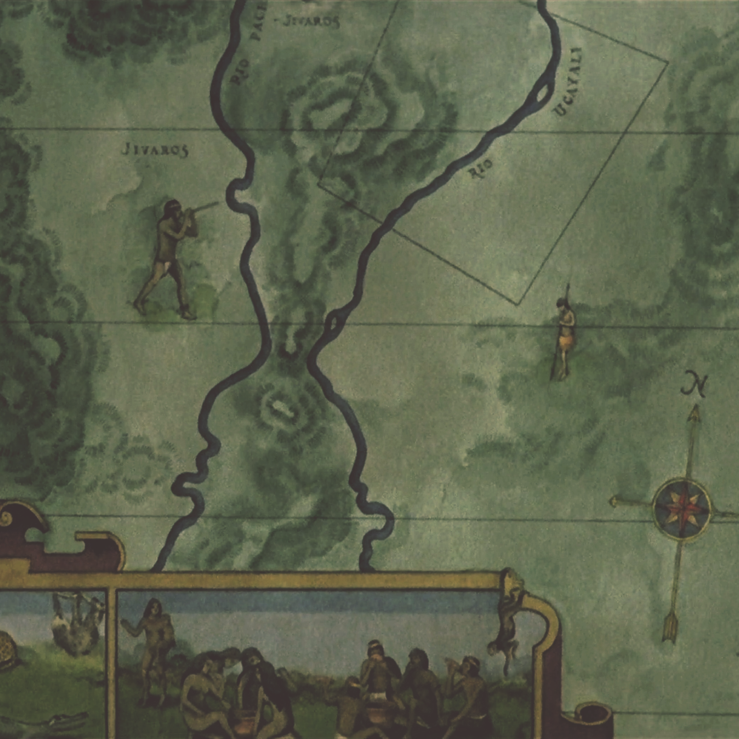
“That's my area. From the Pongo to the mouth of the Ucayali,” said the rubber baron to Fitzcarraldo.
Sources: Werner Herzog, Fitzcarraldo, 1982.
Sources: Werner Herzog, Fitzcarraldo, 1982.
- https://upload.wikimedia.org/wikipedia/commons/5/52/Yuji_tu_-_enhanced_contrast.png
-
Land Survey Handbook, Division of Realty National Wildlife Refuge System, 2015.
-
Bruno Latour & Emilie Hermant, Paris: Invisible City. Trans. Liz Carey-Libbrecht (Paris: La Découverte-Les Empêcheurs de penser en rond, 1998), 28.
-
Werner Herzog on Nature…, YouTube video uploaded by user KubrickIsAGod.
WHO estimates that about 10% of diseases globally are attributable to water‐quality, sanitation, or hygiene‐related problems.1 Human exposure to waterborne infections occurs by contact with contaminated drinking water, recreational water, or food.1 Cholera is an acute diarrhea infection caused by eating or drinking food or water that is contaminated with the bacterium Vibrio cholerae.2 After consuming the contaminated food or water, it takes between 12 hours and 5 days for a person to show symptoms. Researchers have estimated that every year there are up to 4.0 million cases and 143,000 deaths in the world due to the infection.2 Cholera type D can kill within hours if untreated.2 Most people infected do not show symptoms, though the bacteria remains in their feces for up to 10 days. This allows the bacteria to go back into the environment and infect others.2
Cholera is often predictable and preventable. It is eliminated by access to clean water and sanitation facilities and maintaining good hygiene practices.2 Cholera mostly affects the population that does not have access to these basic services of clean water and sanitation facilities. Cholera is ”an indicator of inequity and lack of social development”, according to WHO.2 Oral cholera vaccines and education of food hygiene are useful tools made available and administered by the government in controlling cholera outbreaks.2
Government intervention is key for treatment and prevention of cholera. Unfortunately, cities cannot always be prepared. When a large ice jam on the Danube river caused the banks of the city of Vienna to burst, the overflow of the surrounding rivers and brooks lead to a major outbreak of the disease.3 In response, the Viennese government acted directly after the cholera outbreak of 1830 that killed 2,000 people by covering all of Vienna’s streams.3 Two main sewers nicknamed the “cholera sewers” were built parallel to the River Wien, which led to the Danube.3 Some governments, such as Mexico, have observed the surrounding countries outbreaks and prepared in advance for their countries.Before the occurrence in 1991, the rural physician of the community where the first case occurred was trained on cholera diagnosis and management.4 Supplies for diagnosis and treatment were available at the local clinic and timely reporting of the case at both local and national levels by the epidemiological surveillance system have been utilized as effective measures of disease control.4
Emperor Francis I viewing construction of the "cholera sewer" at St. Charles' Church in 1832.
Sources: “Vienna's Sewer System in the Modern Period,” Vienna’s sewer system in the modern period, December 4, 2015, https://www.wien.gv.at/english/environment/sewer-system/history/modern-period.html.
Sources: “Vienna's Sewer System in the Modern Period,” Vienna’s sewer system in the modern period, December 4, 2015, https://www.wien.gv.at/english/environment/sewer-system/history/modern-period.html.
- J.A. Patz et al., “Climate Change and Infectious Diseases - WHO,” World Health Organization (WHO), accessed March 3, 2021, https://www.who.int/globalchange/publications/climatechangechap6.pdf.
- “Cholera,” accessed March 3, 2021, https://www.who.int/health-topics/cholera#tab=tab_1.
-
“Vienna's Sewer System in the Modern Period,” City of Vienna, December 4, 2015, https://www.wien.gv.at/english/environment/sewer-system/history/modern-period.html.
-
Filiberto Malagón, “Malaria Eradication in Mexico: Some Historico-Parasitological Views On Cold War, Deadly Fevers by Marcos Cueto, Ph.D,” Philosophy, Ethics, and Humanities in Medicine 3, no. 1 (2008): p. 15, https://doi.org/10.1186/1747-5341-3-15.
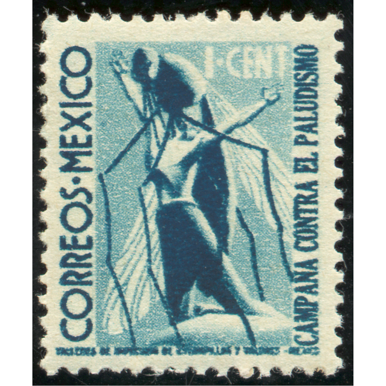
The majority of tropical diseases are caused by improper disposal of sewage wastes or weather events. Rainfall can influence the transport and dissemination of infectious agents while temperature affects tropical diseases growth and survival. With the increase of cloudbursts, catchment from roofs and stress on sewer systems has increased the amount of still standing breeding pools. Governments, like Mexico, have eradicated the diseases by marketing and educating the public. In 1939, the Mexican government issued the postage stamp timbre del mosquito since its precious funding from the Ministry of Health was failing. It was the first postage stamp dedicated to malaria control. In 2017, Mexico became the first country in the Americas to eliminate Trachoma. This was achieved through better sanitation, use of antibiotics and surgery, and using the slogan: “With water, soap and cleanliness you can prevent trachoma”.
Below is WHO’s environmental changes that affect human infectious diseases:
Malaria (increase in breeding sites for mosquitoes)
Helminthiasis (increase in larval contact due to moist soil)
River blindness (decrease in blackfly breeding and disease)
02. Urbanization and urban crowding
Dengue (increase in mosquito breeding sites)
Cutaneous leishmaniasis (increase in proximity and sandfly vectors)
03. Elevated precipitation
Rift valley fever (increase in pools for mosquito breeding)
Hantavirus pulmonary syndrome (increase in rodent food, habitat, and abundance)
04. Ocean Warming
Red tide (increase in toxic algae blooms)
Below is WHO’s environmental changes that affect human infectious diseases:
- Dams, canals, irrigation
Malaria (increase in breeding sites for mosquitoes)
Helminthiasis (increase in larval contact due to moist soil)
River blindness (decrease in blackfly breeding and disease)
02. Urbanization and urban crowding
Dengue (increase in mosquito breeding sites)
Cutaneous leishmaniasis (increase in proximity and sandfly vectors)
03. Elevated precipitation
Rift valley fever (increase in pools for mosquito breeding)
Hantavirus pulmonary syndrome (increase in rodent food, habitat, and abundance)
04. Ocean Warming
Red tide (increase in toxic algae blooms)
Timbre del mosquito in 1939.
Sources: Marcos Cueto, “Malaria Eradication in Mexico: Some Historico-Parasitological Views on Cold War, Deadly Fevers by Marcos Cueto, Ph.D,” Researchgate, June 2008, https://www.researchgate.net/publication/26518094_Malaria_eradication_in_Mexico_Some_historico-parasitological_views_on_Cold_war_deadly_fevers_by_Marcos_Cueto_PhD.
Sources: Marcos Cueto, “Malaria Eradication in Mexico: Some Historico-Parasitological Views on Cold War, Deadly Fevers by Marcos Cueto, Ph.D,” Researchgate, June 2008, https://www.researchgate.net/publication/26518094_Malaria_eradication_in_Mexico_Some_historico-parasitological_views_on_Cold_war_deadly_fevers_by_Marcos_Cueto_PhD.
- “Bethia Kwak, “Mexico Eliminates Infectious Disease Which Is Leading Cause of Blindness,” NBCNews.com (NBCUniversal News Group, April 24, 2017), https://www.nbcnews.com/news/latino/mexico-eliminates-disease-which-leading-cause-blindness-n750306.
-
“Filiberto Malagón, “Malaria Eradication in Mexico: Some Historico-Parasitological Views On Cold War, Deadly Fevers by Marcos Cueto, Ph.D,” Philosophy, Ethics, and Humanities in Medicine 3, no. 1 (2008): p. 15, https://doi.org/10.1186/1747-5341-3-15.
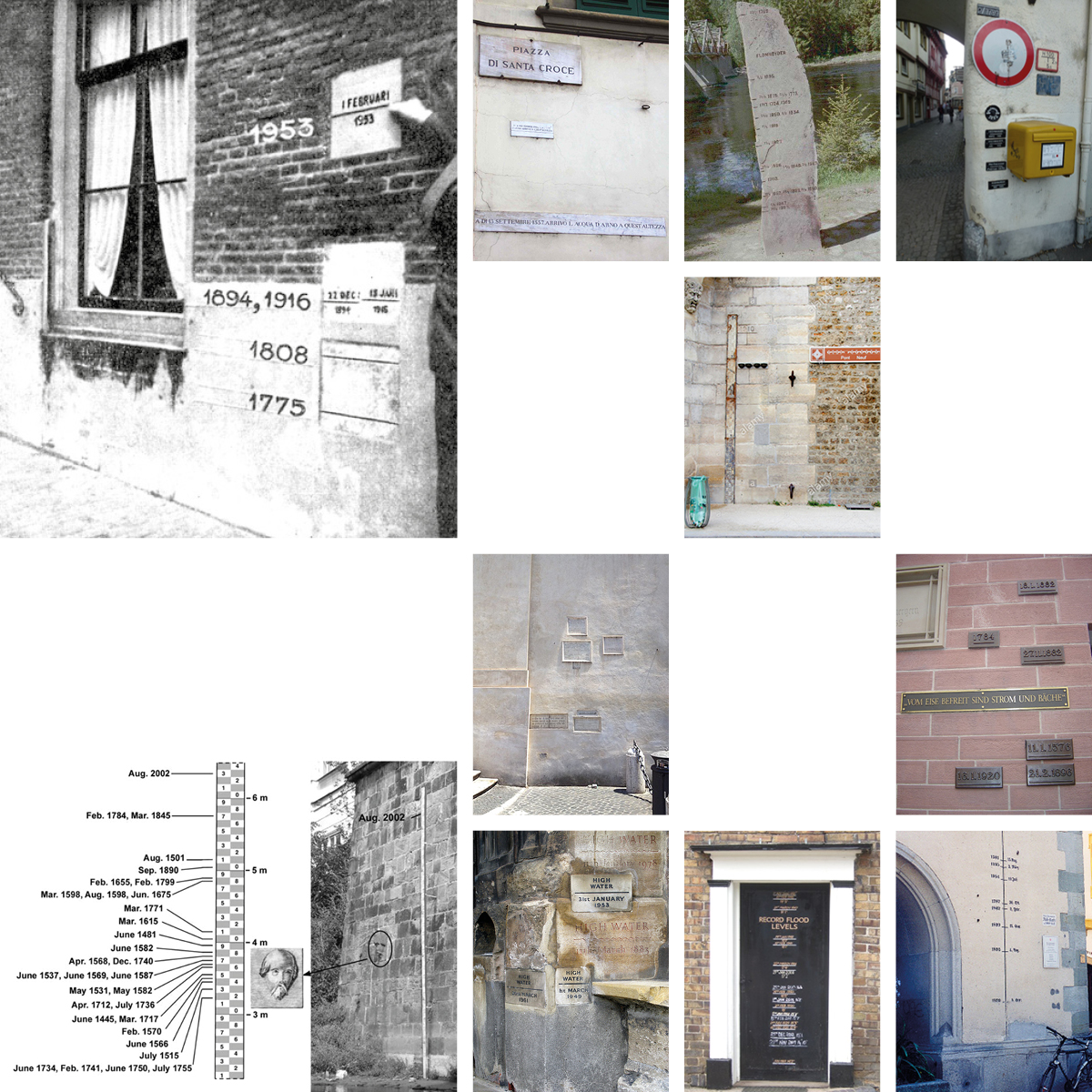
“During the weekend of Saturday, January 31, 1953, hurricane force winds over the North Sea generated a tremendous storm surge that flooded the low-lying coastal regions of the Netherlands, Belgium, and the United Kingdom. The peak high waters hit the coast in the early morning hours, surprising many people in their sleep. In the Netherlands, a country where 75 percent of the land lies either below or less than 3 percent above sea level, nearly 2000 people lost their lives.”1
“In August 2002 a flood caused by over a week of continuous heavy rains ravaged Europe, killing dozens, dispossessing thousands, and causing damage of billions of euros in the Czech Republic, Austria, Germany, Slovakia, Poland, Hungary, Romania and Croatia, as well as in Russia.”2
From the Dutch flood of 1953, to the Great Flood of Paris in 1910 and beyond the European floods of 2002, lies an index of indexes regarding the idea of historical floods, their impact and aftermath. European leaders have gathered to create a better understanding of how to prevent such disasters in the future several times. It took until the 20th century before Romans could deploy both the resources and technology to finally tame the powerful Tiber.3
However, since 1953 the Dutch have taken a zero-tolerance attitude towards flooding. Only 20 days after the flood, officials appointed the Delta Works committee that, in turn, formulated the “Deltaplan” we all know today. The plan entailed blocking the estuary mouths of the big rivers, building dams and storm surge barriers, installing sluices and locks, and heightening and strengthening dikes. Traces of flood devastation remain in the form of flood markers.
The Dutch boy who saves his country by plugging a dyke with his finger4 may be an international legend; for the Dutch, however, the hero is the polder model: expertise and technological advancement. Sharing their knowledge on water management with the world since 1614, when Adrian Boot, hydraulic engineer, was invited to assist Mexico City to drain the lakes in order to prevent flooding. The Dutch expert rejected the idea of drainage, preserved the lakes and proposed regulation instead, reimagining the Dutch hydraulic technology to suit the environmental and social character of the island of Mexico City.5
← Back to Lexicon
Index of flood markers around Europe.
- https://hazards.colorado.edu/article/the-1953-north-sea-flood-in-the-netherlands-impact-and-aftermath
- https://en.wikipedia.org/wiki/2002_European_floods
-
https://apps.carleton.edu/medievalrome/tiber/?story_id=1299594
-
https://www.ft.com/content/44c2d2ee-422c-11ea-bdb5-169ba7be433d
-
"In the Art of My Profession": Adrian Boot and Dutch Water Management in Colonial Mexico City https://www.jstor.org/stable/24394833?seq=1
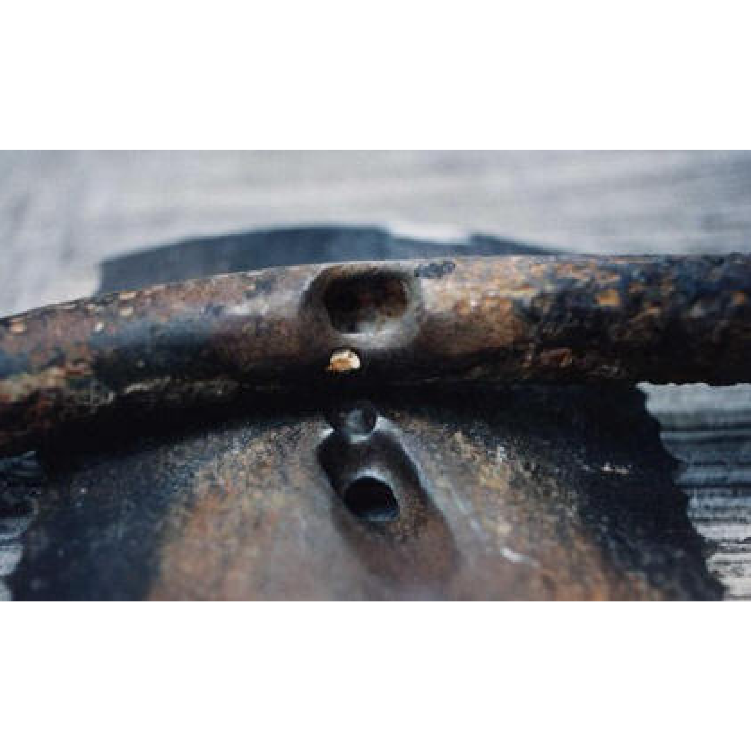
An electrolytic reaction can, at the same time, make a zinc-carbon battery work, but also deprive the Guadalajara city of its life. Under the district of Analco Colonia Atlas, the new water zinc-coated iron pipes that formed the sewerage system of the city were built in a contiguous distance from an existing steel gasoline pipeline. The materials in combination with the underground humidity caused the aforementioned electrolytic reaction. The steel pipe corroded and created a hole in the pipeline. Gasoline found its way out and entered the main sewerage system.
From this integrated underground system of the main sewer and gasoline pipeline, the metro railway could not be excluded. In order to allow the future expansion of metro lines in Guadalajara, the sewer pipes were built in an U-shape, while an inverted syphon was meant to push away the fluids against gravity. However, the design was not flawless, because there was no provision for the removal of gas fumes that subsequently caused their accumulation.
The Guadalajara 1992 Sewer Gas Explosion Disaster was determined from those two factors. On Wednesday, April 22, 1992 a series of sewer gasoline explosions drew an unforgettable line both in the map of the city and in the memory of the people. Over a period of four hours, tore apart 6 miles of sewer pipes and turned heavily trafficked streets, like Gante and 20 de Noviembre, into a pile of rubbles. The multiple blasts caused the death of 206 people; the injury of 1460 people; the damage of 1,148 buildings; the destroyance of 350 businesses and 505 vehicles; and the housing shortage for 15,000 people.
Prior to the explosion, the residents had informed The Guadalajara Fire Department that there is an odor of gasoline coming from the depths of the sewerage system. Together with SIAPA, on Tuesday, April 21, 1992, they visited the Reforma district neighborhood, which was the origin of the complaints.They engaged the state civil defence unit and paradoxically enough,notified Pemex Petroleum to assist in diagnosing the problem. Although never took the blame, Pemex’s history in prior industrial disasters, the amount of required litres of hexane that is need to cause an explosion of this magnitude, the blanket of the fuel covering 16 square blocks near La Nogalera (area of Pemex facilities that is close to the explosion) and the fact that Pemex donate 40 million pesos to "La Asociación 22 de Abril en Guadalajara", might shed the light on the main causes of the catastrophe. However, everything, from the research to the real data, remained blurred.
← Back to Lexicon
Corrosion and hole in larger gasoline pipeline and smaller steel water pipe on top.Photo courtesy of Jose M. Malo, Electrical Research Institute,
Mexico
Sources:http://corrosion-doctors.org/Forms-pitting/sewer.htm
Mexico
Sources:http://corrosion-doctors.org/Forms-pitting/sewer.htm
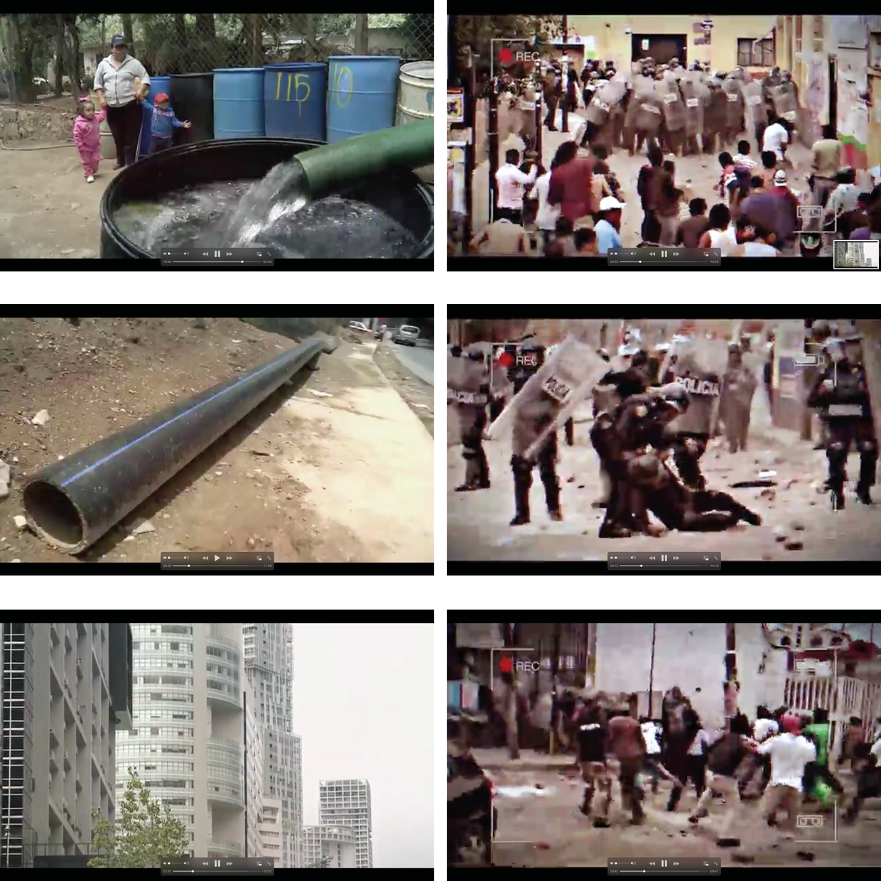
The protest on San Bartolo streets ended with cruel battering of about 100 people. The citizens called this protest and further events Water War and they claimed the “battle” on 21 May was won by their collective defense, although 5 people were arrested. Citizens of San Bartolo Ameyalco gathered on streets when authorities and government water workers came to start connecting local water resources, the volcanic spring in San Bartolo Ameyalco, with city water infrastructure.
Mexico City is under acute water shortage. Remote settlements and poor neighborhoods have limits to water access. According statistic1 there are:
The city’s human rights commission2 reported that rich neighborhoods in Mexico City consume 28 times more water than the poor ones, from 800 to 1,000 liters of water per person per day and just 28 liters correspondingly.
Poor neighborhoods have to protect their limited local water resources if they have, as they themselves have a scarcity of water. Even if some communities have alternative water resources (nature basin or rain water) it is not enough for the whole community and they wait for government trucks for a small supply of water. Any kind of water supply is not recommended to drink, therefore only bottle water is the source of drinking water. The bottle companies have raised the price, making access to drinking water even more unaffordable for most of the population.
The main problem is the lack of investments in the construction and maintenance of wastewater treatment infrastructure. Therefore the old water system started to destroy and more than 40% of water is lost while distributing. The situation has not changed since 2014, as the government can not manage to introduce a new water policy.
← Back to Lexicon
Mexico City is under acute water shortage. Remote settlements and poor neighborhoods have limits to water access. According statistic1 there are:
- 9 million people without drinking water services (five million in rural areas)
- 11 million without sewerage services (7.8 million in rural areas).
- 98 % of water for supplying populated areas (322.97 m3/s), disinfected by chlorination.
The city’s human rights commission2 reported that rich neighborhoods in Mexico City consume 28 times more water than the poor ones, from 800 to 1,000 liters of water per person per day and just 28 liters correspondingly.
Poor neighborhoods have to protect their limited local water resources if they have, as they themselves have a scarcity of water. Even if some communities have alternative water resources (nature basin or rain water) it is not enough for the whole community and they wait for government trucks for a small supply of water. Any kind of water supply is not recommended to drink, therefore only bottle water is the source of drinking water. The bottle companies have raised the price, making access to drinking water even more unaffordable for most of the population.
The main problem is the lack of investments in the construction and maintenance of wastewater treatment infrastructure. Therefore the old water system started to destroy and more than 40% of water is lost while distributing. The situation has not changed since 2014, as the government can not manage to introduce a new water policy.
← Back to Lexicon
Protest in Mexico City for unfair distribution and lack of water supply
Sources:https://america.cgtn.com/2015/04/05/violence-in-mexico-city-over-limited-access-to-clean-water
Sources:https://america.cgtn.com/2015/04/05/violence-in-mexico-city-over-limited-access-to-clean-water
- National Development Plan 2013-2018. Secretaria de Medio Ambiente y Recursos Naturales, , MexicoCity, 2014.
- https://www.americasquarterly.org/article/in-mexico-city-a-black-market-for-lifes-most-basic-commodity-2/
Allegory is a literary device used in numerous forms of art to reveal the hidden meaning of real-world issues and occurrences through a discreet curtain of a symbolic character, place or event.
The allegories of rivers have been in existence since the post-Hellenistic-Age Romans, who personified rivers as mythical figures capable of bringing life and prosperity and at times, capable of wreaking havoc through the power of floods. Romans personified rivers in their artworks as a bull or a man with a bullhead, similar to the Greek myth about the god of rivers- the Achelous, who was defeated by Hercules for the hand of the water nymph Deianeira. Hercules ripped off a horn of Achelous and offered it to Deianeira, who filled it with fruits calling it a 'cornucopia'- another river analogy that turns up repeatedly. Gradually, the rivers became symbolic as bearded reclining men and springs as standing female nymphs throughout the Roman era where long beards, flowing hair with reed crowns, and robes holding urns as origins of the river provided the perception of flowing water. The representation of major rivers - the Tiber, Nile, Euphrates, Tigris, Danube and Rhine - were commonly featured in artworks and coins. The famous painting 'The Four Continents', also known as 'The Four Rivers of Paradise', represents the female personifications of Europe, Asia, Africa and America sitting with the personifications of their respective major rivers – the Danube, the Ganges, the Nile and the Río de la Plata. Vienna's Danube is depicted in the column of Trajan in Rome as a personified male somberly looking over the Roman army as they cross the river. The sculptures in Vienna's water fountains are often personifications of its springs and rivers to celebrate water and its associated technology.
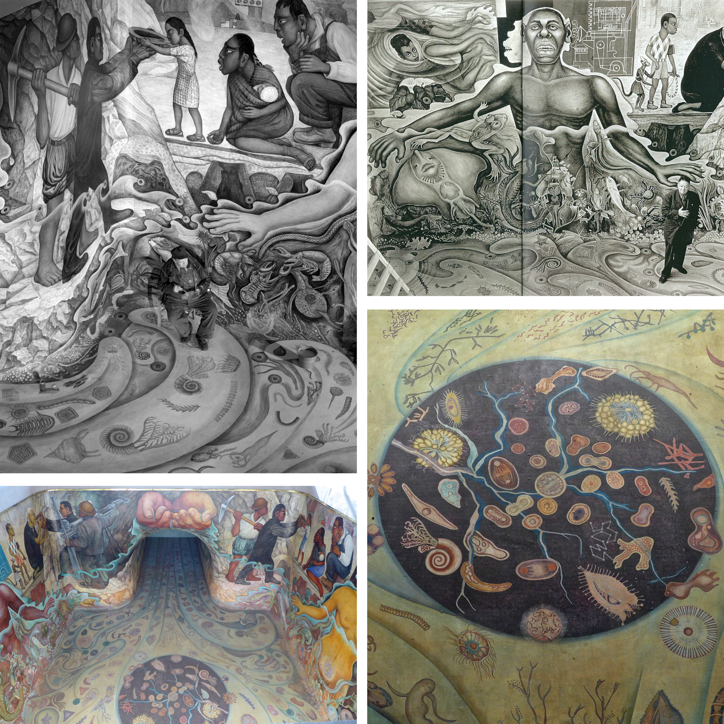
Another allegory of water as an originating element of life on earth and its abiogenesis is observed in 1951, in Rivera's mural of Cárcamo de Dolores. The mural inspired by the theories of Alexander Ivanovich Oparin, a Soviet biochemist, represents the origin of life through various organisms, first men inspired by Olmec art, the importance of workers and technology in providing water to the city, and its importance in daily lives.
← Back to Lexicon
The allegories of rivers have been in existence since the post-Hellenistic-Age Romans, who personified rivers as mythical figures capable of bringing life and prosperity and at times, capable of wreaking havoc through the power of floods. Romans personified rivers in their artworks as a bull or a man with a bullhead, similar to the Greek myth about the god of rivers- the Achelous, who was defeated by Hercules for the hand of the water nymph Deianeira. Hercules ripped off a horn of Achelous and offered it to Deianeira, who filled it with fruits calling it a 'cornucopia'- another river analogy that turns up repeatedly. Gradually, the rivers became symbolic as bearded reclining men and springs as standing female nymphs throughout the Roman era where long beards, flowing hair with reed crowns, and robes holding urns as origins of the river provided the perception of flowing water. The representation of major rivers - the Tiber, Nile, Euphrates, Tigris, Danube and Rhine - were commonly featured in artworks and coins. The famous painting 'The Four Continents', also known as 'The Four Rivers of Paradise', represents the female personifications of Europe, Asia, Africa and America sitting with the personifications of their respective major rivers – the Danube, the Ganges, the Nile and the Río de la Plata. Vienna's Danube is depicted in the column of Trajan in Rome as a personified male somberly looking over the Roman army as they cross the river. The sculptures in Vienna's water fountains are often personifications of its springs and rivers to celebrate water and its associated technology.
Another allegory of water as an originating element of life on earth and its abiogenesis is observed in 1951, in Rivera's mural of Cárcamo de Dolores. The mural inspired by the theories of Alexander Ivanovich Oparin, a Soviet biochemist, represents the origin of life through various organisms, first men inspired by Olmec art, the importance of workers and technology in providing water to the city, and its importance in daily lives.
← Back to Lexicon
Images of Diego Rivera’s mural ‘The Origin of Life’ for Cárcamo de Dolores.
Sources: “Cárcamo de Dolores”, Wikipedia, July 26, 2020, https://es.wikipedia.org/wiki/C%C3%A1rcamo_de_Dolores
Sources: “Cárcamo de Dolores”, Wikipedia, July 26, 2020, https://es.wikipedia.org/wiki/C%C3%A1rcamo_de_Dolores
- “Rivers of art: Ancient Rome”, River Ecology and Research, September 15, 2016, https://paulhumphriesriverecology.wordpress.com/2016/09/15/rivers-of-art-ancient-rome/
- “The Four Continents”, Wikipedia, March 25, 2021, https://en.wikipedia.org/wiki/The_Four_Continents
- “Departure across the Danube”, Omeka RSS, accessed May 03, 2021, http://omeka.wellesley.edu/piranesi-rome/exhibits/show/column-for-trajan/departure-across-the-danube
-
“Cárcamo de Dolores”, Wikipedia, July 26, 2020, https://es.wikipedia.org/wiki/C%C3%A1rcamo_de_Dolores
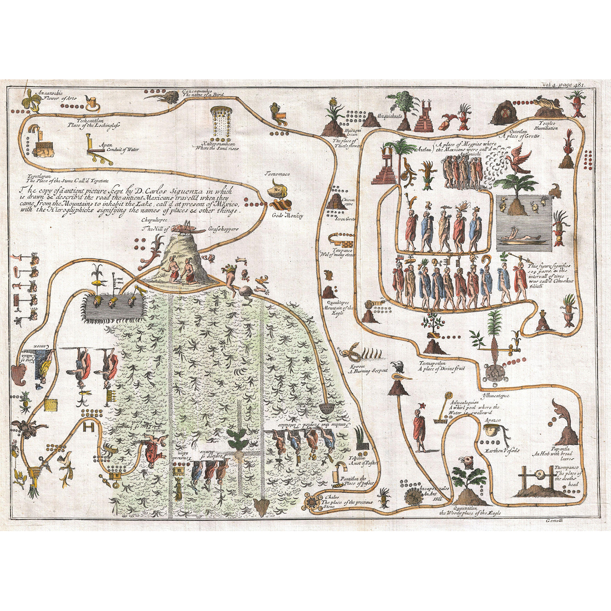
Legend has it, that -precisely- on May 24, 1065 CE, the Aztecs ventured on an epic migration from their ancestral homeland, Aztlan (“Place of Reeds” or “Place of Egrets”), to the shores of Lake Texcoco, in central Mexico. There, by forming another altépetl, they founded the city of Tenochtitlan, which in time spawned the vast Aztec Empire, famously encountered by Hernan Cortez several hundred years later. The altépetl (plural altepeme) was the local ethnical-political-territorial entity or “city-state” in Mesoamerican societies. The indigenous identity during the Aztec Empire was defined by the altépetl. The word actually combines the Nahuatl word for “water”, ātl, with tepētl, meaning “mountain”, anchoring civilization in a clearly defined territory.1 The Mexican culture and origins are inextricably tied to the elements of earth and water.
This unusual 1704 map, drawn by Giovanni Francesco Gemelli Careri, is the first published representation of the legendary Aztec migration from Aztlan, a mysterious paradise somewhere to the northwest of Mexico, to Chapultepec Hill. The road that the ancient Mexicans travelled when they came from the mountain on the lake in order to inhabit Lake Texcoco, is drawn and described with the Hieroglyphics signifying the names of content and places. Aztlan appears here in the upper right corner also as a lake, with a mountain and a palm tree. The progression meanders along many paths and digressions to finally arrive to the upper right quadrant, where we can discern a hill upon which rests a gigantic Grasshopper. This is Chapultepec, known nowadays as Mexico City.2
This unusual 1704 map, drawn by Giovanni Francesco Gemelli Careri, is the first published representation of the legendary Aztec migration from Aztlan, a mysterious paradise somewhere to the northwest of Mexico, to Chapultepec Hill. The road that the ancient Mexicans travelled when they came from the mountain on the lake in order to inhabit Lake Texcoco, is drawn and described with the Hieroglyphics signifying the names of content and places. Aztlan appears here in the upper right corner also as a lake, with a mountain and a palm tree. The progression meanders along many paths and digressions to finally arrive to the upper right quadrant, where we can discern a hill upon which rests a gigantic Grasshopper. This is Chapultepec, known nowadays as Mexico City.2
Gemelli Map of the Aztec Migration from Aztlan to Chapultepec.
Cárcamo de Dolores, also called del Lerma, is a hydraulic structure located in the Chapultepec Forest of Mexico City. Mexico City receives its fresh water supply from the Cutzamala Distribution System, whose first half of stage I, called the Lerma system, conditioned the water from the Lerma river through channels, pipes, tunnels and storage tanks in 1951. Cárcamo de Dolores, currently part of the Museum of Natural History, was constructed in the same year and is located where the Lerma system’s Atarasquillo - Dos Ríos tunnel, a structure 2.5 meters in diameter, culminates.
The structure was designed by the combined efforts of muralist Diego Rivera, architect Ricardo Rivas and engineer Eduardo Molina as a tribute to water. It was an attempt to integrate public art into a functional building and create a vital concept based on the applications of water in Mexican culture, references to the art of Mesoamerican cultures, and the celebration of technological effort associated with the water distribution system. The building by Rivas is a functionalist building borrowing the form of a classical temple with the roof as a mound and columns on the patio; as well as an abstraction of the elements of the Mesoamerican cultures which are visible in the four gargoyles of the building. Diego Rivera created a mural inside the tunnel, on the four walls and floor of the storage tank where water flows in from the gully. The mural remained underwater for 40 years and was designed considering the effects of water on the mural. The installation of a water fountain outside the building with a sculpture of the god Tlaloc, the god of wind and water, was constructed by Rivera, essentially supposed to be seen from the sky due to its close proximity to the Mexican Airport. The deity has two heads and is built with mosaics and coloured stones. In 2010, along with the restoration of the mural and the fountain, artist Ariel Guzik installed a Lambdoma chamber which is a sound intervention using the technology of sound waves inside the building. The architect Alberto Kalach, in 2010, redesigned the landscape and created a plaza around the building with a capacity of 700 people.
← Back to Lexicon
Top view of the hydraulic structure- Cárcamo de Dolores in Mexico City.
Sources: “The Fabulous Underwater Mural of Chapultepec”, Mxcity, accessed May 03, 2021, https://en.mxcity.mx/2016/06/underwater-mural/
Sources: “The Fabulous Underwater Mural of Chapultepec”, Mxcity, accessed May 03, 2021, https://en.mxcity.mx/2016/06/underwater-mural/
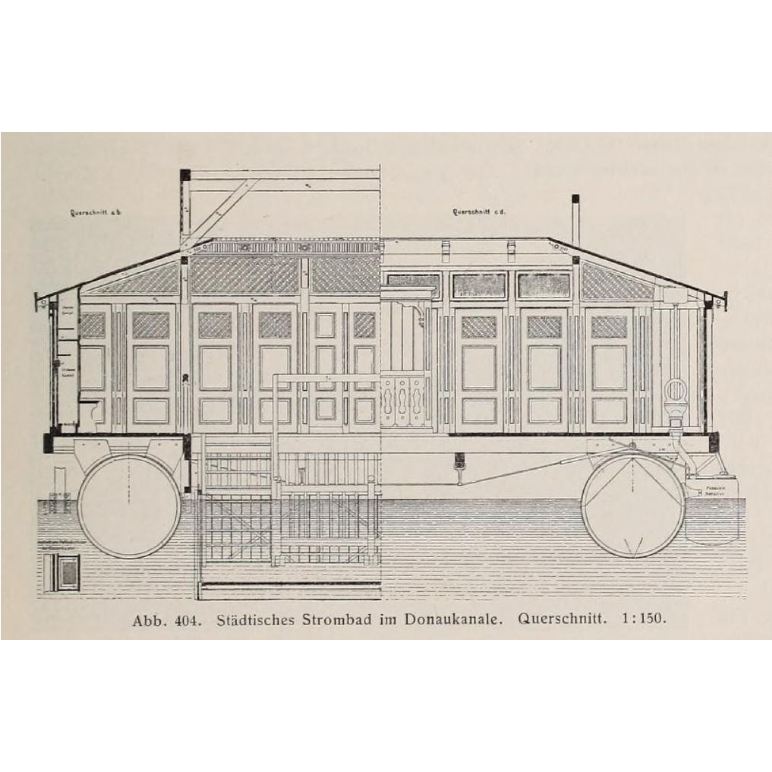
Public baths and saunas have been an integral part of the Viennese culture for centuries. The people of Vienna depended on public water for bathing, especially before the invention of indoor plumbing in their homes. Swimming in the Danube was extremely popular amongst the Viennese even before the 15th century; subsequently facing a decline with the ban on public swimming in the river to maintain hygiene with the rise of syphilis and plague.
The renewed change in attitudes with the Enlightenment period in the 18th century brought back the tradition of swimming with bathhouses and spas and recognized it as a measure for cleanliness, physical relaxation, and health betterment. The first cold water baths, affordable only to the wealthy, were constructed as floating ships on the Danube to raise physical defences. Soon, Vienna encountered a rise in public baths with free-of-charge baths built by the municipality of Vienna in 1799, the military swimming school in 1813, the first Austrian ladies' swimming school in 1831 before which women had no access to pools; and warm-water urban baths with a capacity of more than 1200 bathers in the Danube-regulation period between 1869-1875. By the mid 19th century, private bathing facilities with heated water similar to the Roman thermal baths were constructed. The Central Bathhouse, constructed in 1889 in the city centre, gained a lot of social reputation and is regarded as the oldest indoor bathing establishment of Vienna. River bathing boat facilities, 60 meters long and 10 meters wide, were constructed on the Danube canal in 1904 following the improvements in the sewage system of Vienna. The Amalienbad, a municipal indoor swimming pool with Art-Deco interiors, was built in 1926 and was "the largest and most modern bathing establishment in Central Europe".
Due to the numerous baths around the Old Danube, Vienna possessed an international reputation as "the city of baths" by the 1920s. However, many historic baths were destroyed during the Second World War. Efforts to rejuvenate them have been made ever since, especially following the implementation of the 1968 public bath concept with 14 pools to be built within a short period of seven years.
← Back to Lexicon
Cross-Section of the Urban river bath in the Danube Canal. Scale 1:15.
Sources: Kortz, Paul, “Vienna at the beginning of the 20th century- A guide in a technical and artistic direction.”, Austrian Association of Engineers and Architects Vienna, Gerlach & Wiedling, 1906. Volume 2, 1905, p. 274, fig. 404, https://archive.org/details/wienamanfangdesx02kort/page/276/mode/2up?view=theater
Sources: Kortz, Paul, “Vienna at the beginning of the 20th century- A guide in a technical and artistic direction.”, Austrian Association of Engineers and Architects Vienna, Gerlach & Wiedling, 1906. Volume 2, 1905, p. 274, fig. 404, https://archive.org/details/wienamanfangdesx02kort/page/276/mode/2up?view=theater
- “Die ehemaligen Bäder am Donaukanal”, Link zur Startseite, accessed May 03, 2021, https://magazin.wienmuseum.at/die-ehemaligen-baeder-am-donaukanal
- “Where the Elites Bathed: Vienna's Central Bath”, Secret Vienna Tours, November 04, 2019, https://secretvienna.org/where-the-elites-bathed-viennas-central-bath/
-
“Central Bathhouse Vienna”, Wikipedia, April 21, 2021, https://en.wikipedia.org/wiki/Central_Bathhouse_Vienna
-
“Bäder”, – Wien Geschichte Wiki, accessed May 03, 2021, https://www.geschichtewiki.wien.gv.at/B%C3%A4der

Isolated efforts of conservation and geotourism that develop into joint umbrella organizations like the Association of Austrian Nature Parks and/or work with larger conservation organizations such as the IUCN or UNESCO.
The spring water supply of Vienna comes predominantly from the Styrian Eisenwurzen Nature Park. You can even go to the Wildalpen Spring Water Museum and see the Kläffer spring. Historically, this region was settled in the 11th century and became an iron mining region from the 16th to the 19th century when it transitioned into a tourism focused region. Franz Kraus was an important figure in this transition as he was a very active member in the geological and science field and became a correspondent of the Federal Geological Institute (GBA). As he became more involved in caves and became a speleologist, he brought the Österreichische Touristenklub (OTK) in to collaborate with the caving association he co-founded. Within months he bought a cave and created a tunnel to it, opening it to the public in 1881. By 1883, a small power station was built to make it the first electrically lit cave open to the public and during this the locals decided to make Kraus an honorary member of their community and named it Kraushöhle. After this, Kraus continued to guide the speleology department of the OTK to survey the water conditions in the Carniola region which would go on to influence the melioration projects in the Karst Area.
In 1959, the Österreichisches Wasserrechtsgesetz was passed regulating and defining water. Although nature protections weren’t explicitly mentioned, this policy set precedents by requiring sustainable management especially in regards to water pollution. However, in the Styria region they had already established hunting laws as early as 1947, limiting hunting grounds and species allowed. In the Styria Land Use Planning Law of 1974, conservation and protections for indigenous flora and fauna were established. Then in 1976, the Styrian Nature Conservation Act created 36 Landscape Protection Areas which are not as protected as Nature Parks but are also designated by the state. Soon after, the Styria Mountain and Nature Rescue Service were established in 1977 through local legislation to be in charge of promoting the protection of nature. Most other states did not pass legislation regarding Landscape Protection Areas until the 2000s, after the Nature Parks formed the Verband der Naturparke Österreichs (VNO) in 1995.
← Back to Lexicon
Organizational network adoption and structure originating from Kraushöhle at Steirische Eisenwurzen
Sources: xx
Sources: xx
Projects
10 speculative contributions are situated within the water cycle, addressing the greater territory of Mexico City. The proposals draw upon the lexicon and the atlas, continuing the built-up lines of inquiry and argumentation.
The 10 architectural projects are broken down to three categories: Aquifer, Water Supply-Consumption, and Waste, composing Mexico City’s water cycle.
![]()
10 contributions placed in the Mexico valley (water cycle)
![]()
10 contributions placed in the Mexico Valley (section)
![]()
10 contributions placed in the Mexico Valley (plan)
![]()