A phenomenon that occurs when due to human activities, a species has access to more nutrients than normal, causing a bloom in population. This leads to an imbalance in the ecosystem that is detrimental to other species.
The Algae Bloom, in particular, is one resulting from cultural eutrophication, where the two main contributors of minerals and nutrients into the water are raw sewage and agriculture. However, any usage including recreational use can contribute to this process and is one that has occurred historically. Eutrophication, most commonly the accumulation of phosphate and nitrate, occurs naturally and any human presence has meant the existence of cultural eutrophication. Say in the medieval era, the effects of this accumulation may have been no less than it is now, but a change did occur in that the effects are no longer localized and the Algae Blooms are being seen at a global scale. This is partially due to densification of population and industrial fertilizer use, however of note is the movement of nutrients in the form of food which also has a water amount attached in terms of production. Beyond the globalizing nature of agriculture, animal husbandry contributes to this process in the form of animal sewage along with any fertilizers used to produce any feed, most of which ends up in the water cycle.
As water tends to end up in the ocean, coastal and delta areas tend to be the most impacted by Algae Blooms, but areas with low water exchange like an Endorheic Basin are also particularly susceptible. Additionally, with the fracturing of the water cycle through dams, sewers, and globalized sources of phosphorus like the Kola Peninsula, the effects and contributions to Algae Blooms can reach far inland. However, cultural eutrophication in itself is a natural part of human existence and phenomenon such as the “Red Tide” are from extreme cases resulting from an incomplete biogeochemical water cycle.
← Back to Lexicon
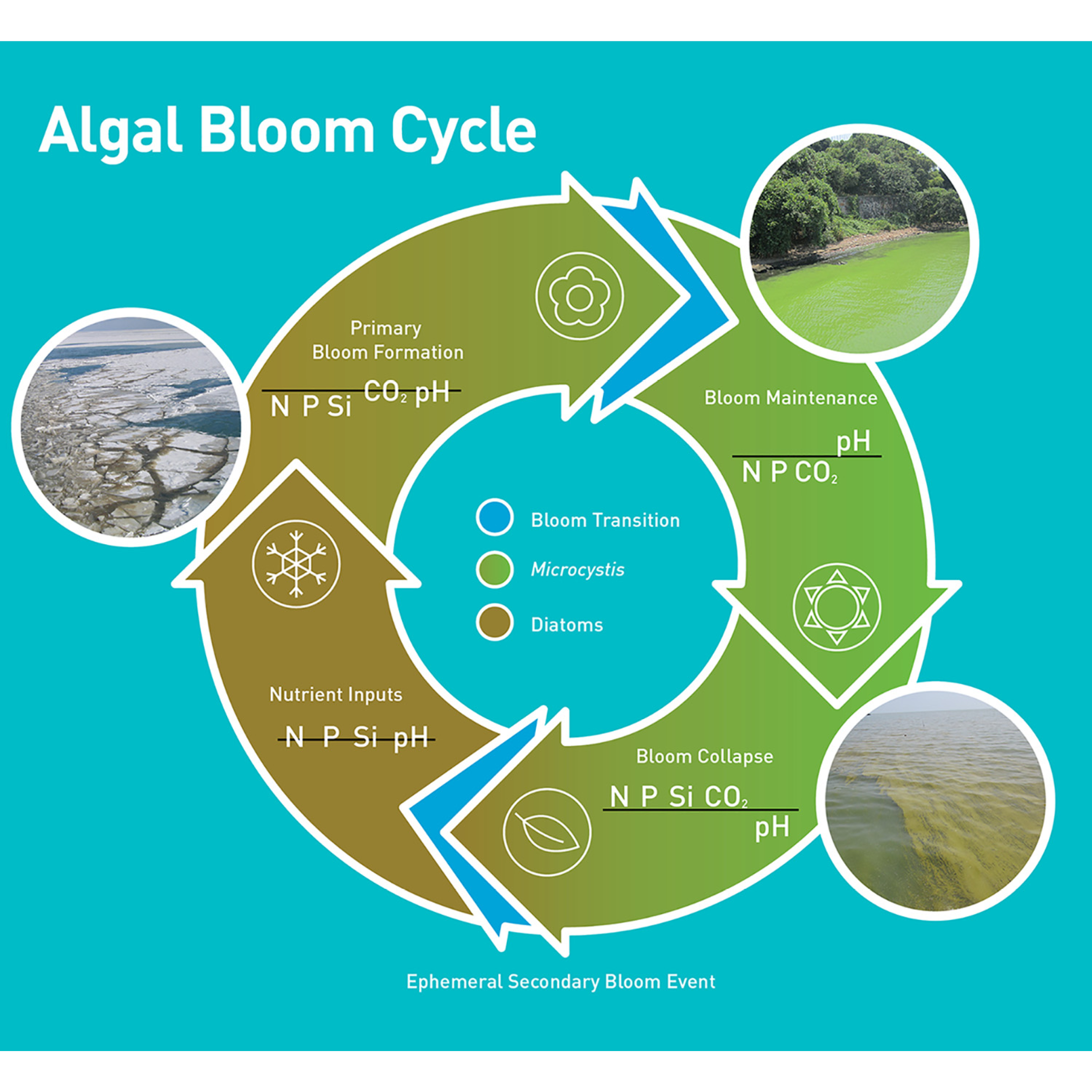
Seasonal bloom cycle of a cyanobacteria, Microcystis, that is prevalent in freshwater
Sources: Wilhelm, Steven W., George S. Bullerjahn, and R. Michael L. McKay. "The Complicated and Confusing Ecology of Microcystis Blooms." mBio 11.3 (2020): e00529-20. Web. 03 May. 2021.
Sources: Wilhelm, Steven W., George S. Bullerjahn, and R. Michael L. McKay. "The Complicated and Confusing Ecology of Microcystis Blooms." mBio 11.3 (2020): e00529-20. Web. 03 May. 2021.
- Wassmann, Paul. (2005). Cultural eutrophication: perspectives and prospects. Drainage Basin Inputs and Eutrophication: An Integrated Approach.
Fischer Landfill
![]()
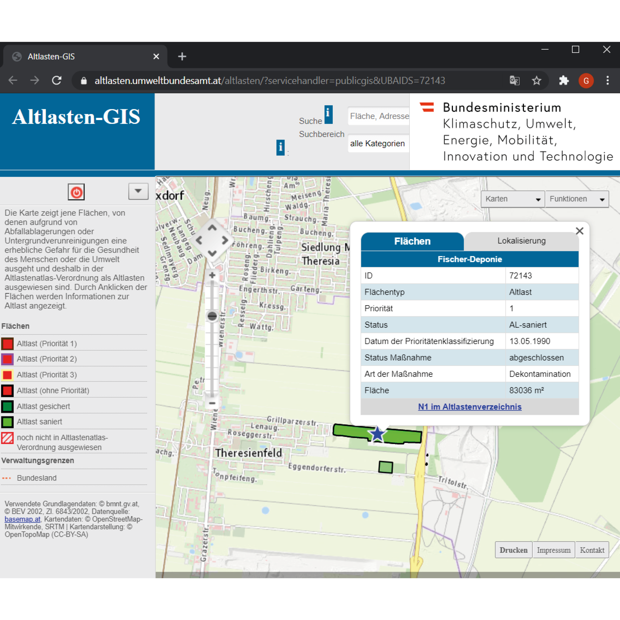
The atlas of the contaminated sites is to provide maps that illustrate the areas of waste deposits or subsurface contamination that threaten either the human health or the environment. Contaminated areas are mapped and listed with their unique ID, priority, status, area, and location. The question now arises: could the contamination be restricted to a limited circumscribed area?
The example of Fischer-Deponie - ID:72143, an area located in the agricultural area of Theresienfeld suggest a paradigm of subsurface contamination but also of groundwater contamination. The landfill was created from a gravel pit in the well drained-bed of the Mitterndorfer Senke, one of the largest reservoirs in Central Europe. However, around 550,000 cubic meters of various types of waste were deposited in an area of around 70,000 square meters without any measures to protect the groundwater. In 1972 the Waxina company deposited poisonous barrels and the latter tenant Johann Fischer, industrial and commercial waste. The operations were taking place from 1972 until 1987, when the authorities managed to enforce the final closure and rehabilitation of the landfill.
Groundwater investigations revealed significantly higher levels of chlorinated hydrocarbons (especially 1,1,1-trichloroethane and trichloroethene) and aromatic hydrocarbons. The massive contamination of the groundwater affected a groundwater body that plays a vital role in the drinking water supply in Easte Austria. Thus, a row of barrage wells was built to treat the extracted groundwater.
The subsoil in the area of the contaminated site is made up of well-drained, Quaternary gravel, which is partially solidified. In the depth of 20 to 25 m, there is a slightly permeable, fine-grained sediment layer, a low-permeability intermediate layer. The groundwater, over the entire length of the dump flows over this layer. The groundwater in the immediate outflow is collected by means of a barrier well and, after cleaning, is drained away again further downstream. A waterworks upstream of the Fischer landfill has been partially shut down due to the supra-regional pollution of the groundwater. The former old deposit is currently not in use.
As a result of the pollution that has already occurred, water supply systems in the area of the Mitterndorfer Basin had to be abandoned. The Fischer landfill, as one of the causes of groundwater pollution, posed an acute threat to a groundwater resource of supraregional importance. The old deposit posed a significant threat to the environment and was to be assessed as a contaminated site in the sense of the ALSAG.
In 2007, after procedures of redevelopment and renovation by the company BALSA GmbH, the Fischer landfill assessed renovated since the remediation foals have been fully achieved and that there are no longer any significant effects on the protected groundwater from the former Fischer landfill and are not expected in the future.
← Back to Lexicon
The atlas of the contaminated sites illustrating the location of Fischer Landfill and the tab of its information.
Sources:https://altlasten.umweltbundesamt.at/altlasten/?servicehandler=publicgis&UBAIDS=72143
Sources:https://altlasten.umweltbundesamt.at/altlasten/?servicehandler=publicgis&UBAIDS=72143
A program dedicated to taking on extremely costly clean up projects resulting from past uses.
The Comprehensive Environmental Response, Compensation, and Liabilities Act of 1980 (CERCLA) was passed by the US federal government to investigate and clean up areas that were contaminated with hazardous substances. The Environmental Protection Agency is in charge of this “Superfund” named by the astronomical costs of cleaning up these sites. Out of 40,000 identified sites federally, 1,600 of them are on the National Priorities List that generally require long-term attention called remedial actions. The ones that require short-term attention are referred to as removal actions.
First, the Superfund tries to bring human exposure to these hazardous substances under control by removal of the contamination as well as through monitoring and control of the area use. For example, by implementing groundwater use restrictions. Once the site is under control, the Superfund then tries to open the site back up by bringing new uses there through redevelopment.
In order to achieve this, the Superfund is in charge of finding the potentially responsible parties. Legally, they have established that the seller of a contaminated site is still responsible for the clean up and that this liability is not something that can be passed onto the buyer. In cases where a potentially responsible party cannot be identified, they receive government funds from taxes which until 1995 was applied to oil companies.
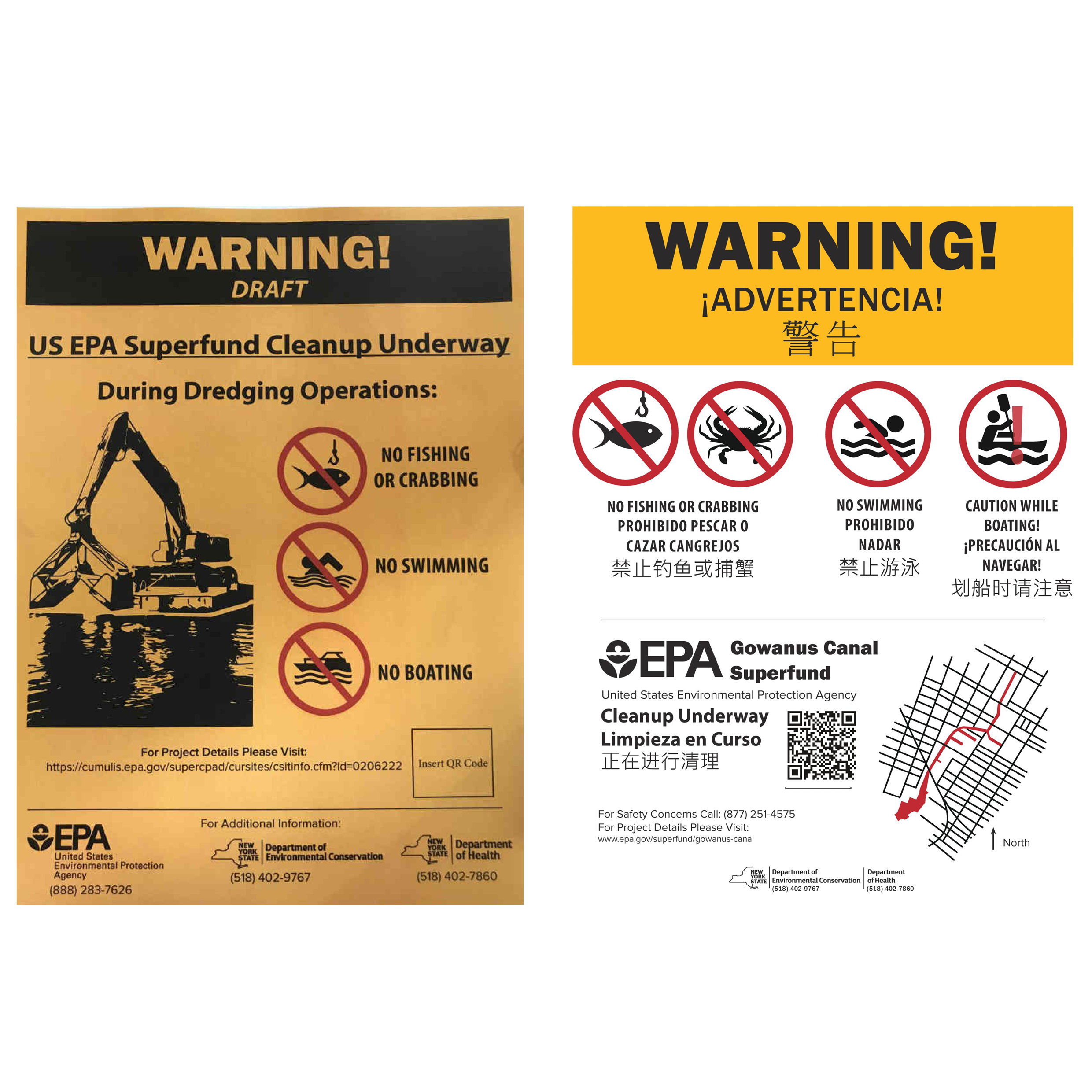
When placing the signs to alert the community around the Gowanus Canal in Brooklyn, NY, of the work being done, the New York State Department of Health was in charge of the project and interfacing with the Gowanus Canal Community Advisory Group. The sign had three drafts before being approved by vote, with one of the changes including a change from “NO BOATING” to “CAUTION WHILE BOATING!” for a group of local recreational canoers.
← Back to Lexicon
Warning sign development with community input for the Gowanus Canal in 2018
Sources: xx
Sources: xx
- https://www.brooklynpaper.com/reel-conundrum-new-signs-ban-fishing-in-toxic-gowanus-but-some-say-they-dont-do-enough-to-discourage-sport/
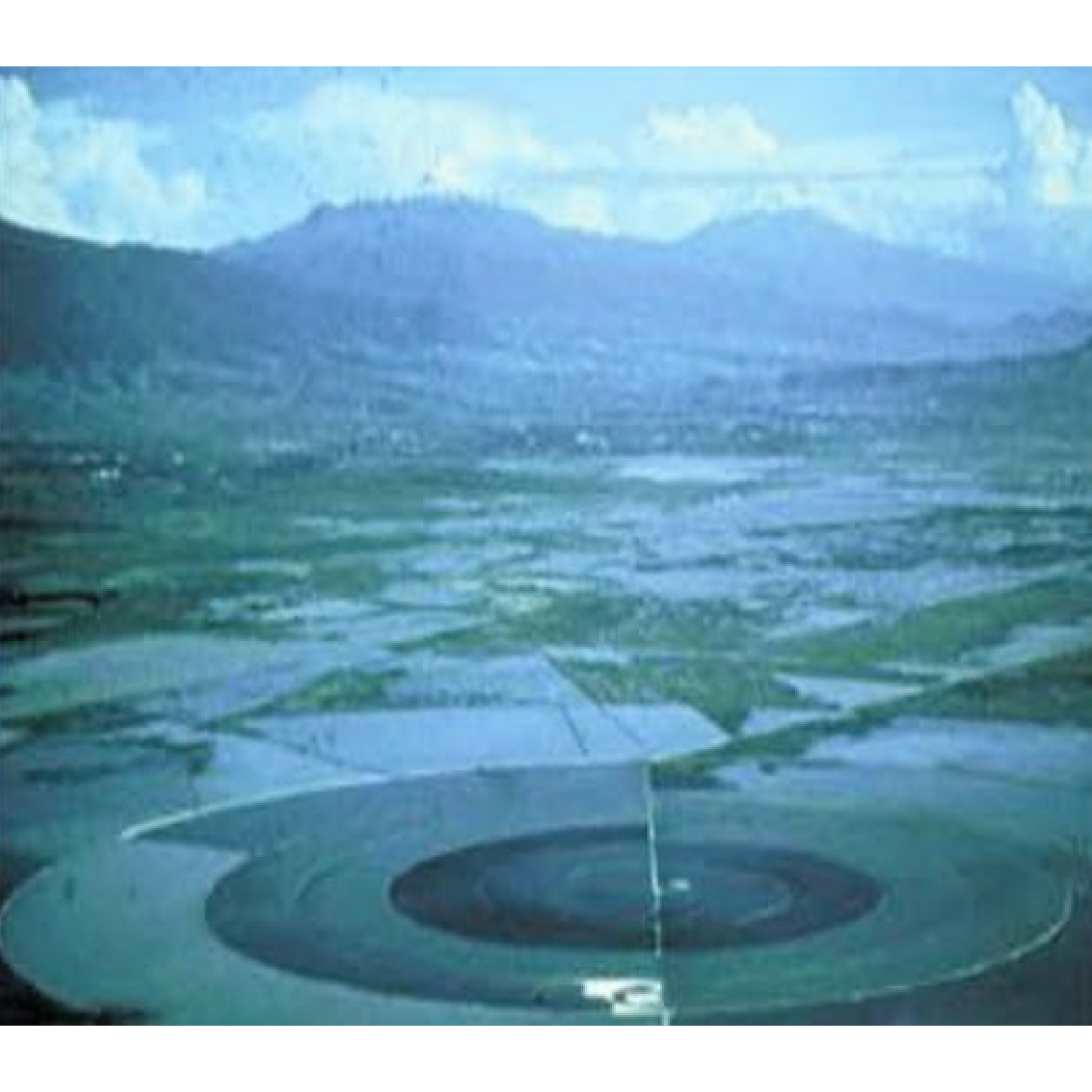
Caracol Ecatepec was built in 1942 by SOSA Texcoco to desalinate the water of Lake Texcoco. Designed by Nabor Carrillo, the retention basin and a desalination plant were located over the drained site of Lake Texcoco.1 The 3,200m in diameter basin was called “the snail” from its short spiral-shaped concrete levee that circles it.1 The water from the lake entered from a pump house on an island in the middle of the basin and was channeled outward and clockwise.1 The channel increases in width while decreases in depth until it becomes too shallow to flow further.1 The water evaporates in the opposite direction.1 This allowed for a predictable collection of 100 tons of salts per day.1 The desalinated water that was extracted was used by the factories nearby.
A lack of understanding of the actual process caused the process to be more expensive than expected. In 1967, Lake Texcoco was further exploited by discovering and cultivating its blue algae. The algae are collected by screens and processed into dry nutritional supplement powder for commercial sale branded "Spirulina Mexicana". In December 1986, SOSA Texcoco went bankrupt from a series of strikes and the slow hand labor forced by its snail shape. In 1991, the company and facilities were sold at a low rate to a collective of investors called Sociedad Anónima de Capital Variable. Sociedad Anónima de Capital Variable tried to negotiate the collective bargaining contracts for manual laborers that were mandated upon SOSA Texcoco by the Madrid administration. In 1991, the Mexican Supreme Court ruled that the old contracts must be honored if any profit-seeking business were to resume operations. This forced Sociedad Anónima de Capital Variableto to fold. The government then liquidated the original deed, voided the worker contracts, and seized the inactive facility as a public asset.
In 2000, Caracol was redeveloped with 13,000 new units of low-income housing and a shopping mall. With the additional development and the informal growing settlement of El Salado nearby, the basin cannot expand.The basin is currently owned by the Mexican government and in use as a reservoir for industrial facilities within Mexico City. It is filled from a junction with the Canal de Sal that runs along the south edge of the facility and connects it to the rest of the Mexico City drainage basin.
← Back to Lexicon
El Caracol in mid-20th century.
Sources: Imen Hamed, “The Evolution and Versatility of Microalgal Biotechnology: A Review,” Wiley Online Library (John Wiley & Sons, Ltd, September 26, 2016), https://onlinelibrary.wiley.com/doi/full/10.1111/1541-4337.12227.
Sources: Imen Hamed, “The Evolution and Versatility of Microalgal Biotechnology: A Review,” Wiley Online Library (John Wiley & Sons, Ltd, September 26, 2016), https://onlinelibrary.wiley.com/doi/full/10.1111/1541-4337.12227.
- Jose Castillo, “Peripheral Landscapes, El Caracol, Mexico City,” Architectural Design 78, no. 1 (2008): pp. 64-67, https://doi.org/10.1002/ad.611.
-
“El Caracol, Ecatepec,” Wikipedia (Wikimedia Foundation, April 10, 2020), https://en.wikipedia.org/wiki/El_Caracol,_Ecatepec.
The plumbing system reaches its widespread use during the ancient Rome period, which saw the introduction of an expansive system of aqueducts, wastewater removal, and widespread use of lead pipes. Romans built a water channel that carried water from the mountain into the city, which was distributed through an underground supply line made of lead. This is where the term plumbing originated as “Plumbus” in Latin mean lead.
The danger of lead poisoning was already being reported as early as 14 B.C by the Roman architect, Vitruvius. Later, similar cases of lead poisoning were being reported through time from Europe and the US. However, even with the danger of lead becoming increasingly obvious, the warning signs continued to be ignored.
In 1920 many cities and towns in the US were prohibiting or restricting the use of lead material, but an organization called LIA (Lead Industry Association) managed to carry out an effective campaign to prolonged and promoted the use of lead-based material for paint, plumbing, and gas. This movement also supported by the professional plumbers because the installation of lead fixture and pipes required expertise that other did not possess. To maintain the sales of lead material, the LIA lobbied the government at all levels and targeted the people who both designed and installed water distribution systems with educational material and other resources at least until the 1970s.
Today, even after lead being banned, the leftover lead still presents in our environment, the poison still lingers in our soil, dust and chipped from deteriorating house paint and lead-soldered pipes of an aging house. There are strategies to mitigate these exposure risks in the short term such as internal corrosion control, flushing, and filtering; but the only long-term solution is to replace all the lead pipe with other alternative materials such as copper, PVP, CPVC, or PEX pipes.
← Back to Lexicon
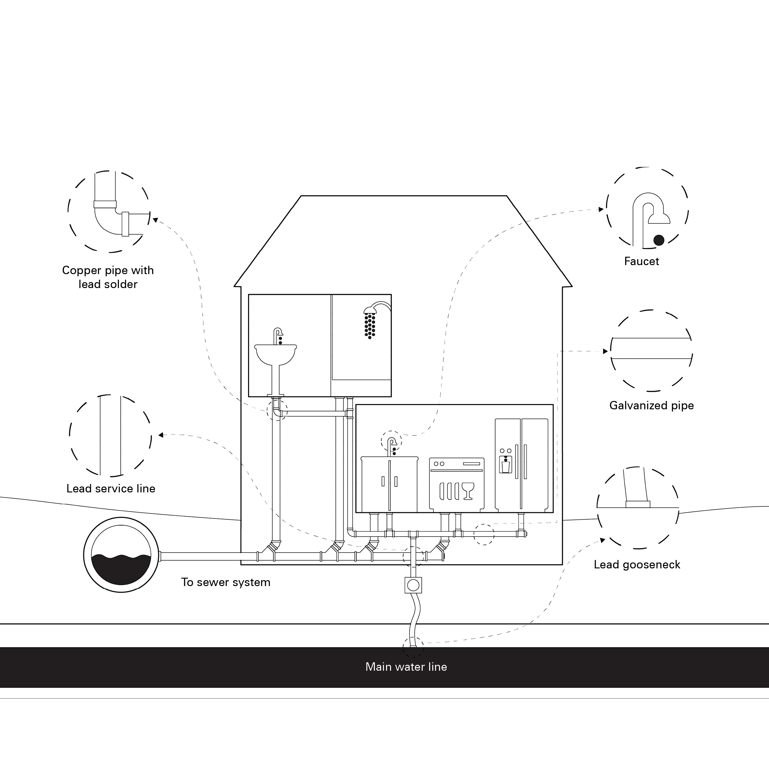
Redraw of Sources of Lead in Drinking Water
Sources: EPA. Source of Lead in Drinking Water. PDF File. May 2, 2021.
Sources: EPA. Source of Lead in Drinking Water. PDF File. May 2, 2021.
- Sohn, Emily. Lead: Versatile Metal, Long Legacy. Dartmouth. Accessed May 2, 2021. https://sites.dartmouth.edu/toxmetal/more-metals/lead-versatile-metal-long-legacy/.
- Lead Service Line. Wikipedia. Wikimedia Foundation, May 2, 2021. https://en.wikipedia.org/wiki/Lead_service_line.
- Plumbing. Wikipedia. Wikimedia Foundation, April 20, 2021. https://en.wikipedia.org/wiki/Plumbing.
- Rabin, Richard. “The Lead Industry and Lead Water Pipes “A MODEST CAMPAIGN.” American Journal of Public Health 98, no. 9 (2008): 1584–92.