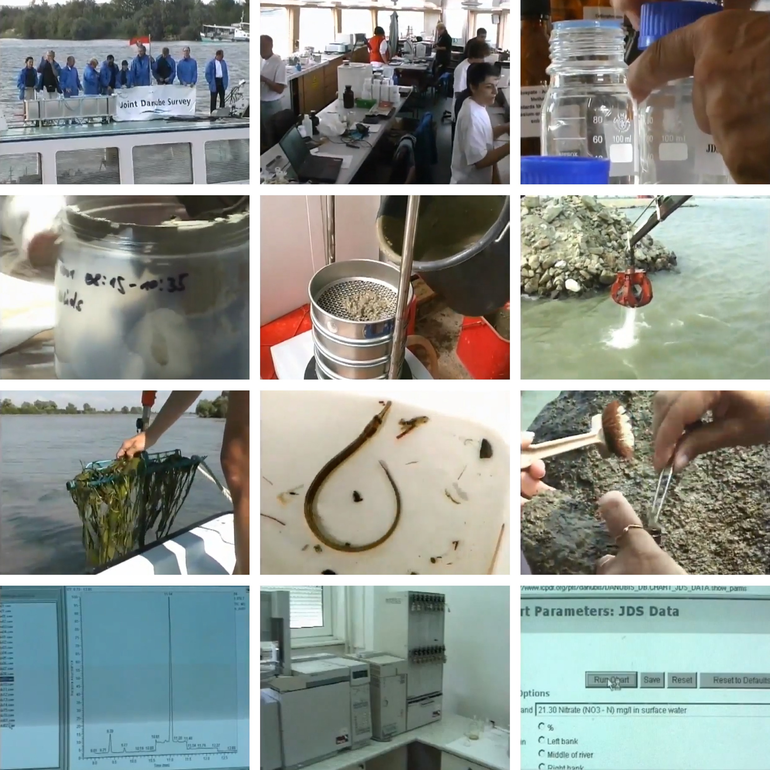
In the summer of 2001, a group of scientists from Germany, Austria, Slovakia, Hungary, Yugoslavia, Bulgaria, and Romania boarded a fleet fully equipped with scientific apparatus and computers. Their goal was to perform a thorough investigation of the Danube Basin on chemical and biological water status in response to the EU’s new water directive. All the data and samples were collected under one uniform standard procedure and analyzed in one single laboratory, which eliminated the possibility of various data interpretation to its maximum, thus constructing a highly comparative database and a comprehensive understanding of the river. The survey had four indices: water quality, suspended solids, sediments and biological samples. Each of them was conducted multiple times in different segments of the Danube River to monitor urban, agricultural and industrial activities’ impact in real-time. Later, all samples were sent to the Austrian Research Center in Vienna for further analysis and archive.
The concept of regarding the Danube Basin as a collective water body across countries was first legislated in 1985’s Bucharest Declaration. So far (2020), ICPDR has formed four joint research teams as a part of a transnational monitoring network. More than merely scientific research, the result of the survey was published by the group and further served as guidelines for policy making that dedicate to maintain the ecological status of the surface water.
← Back to Lexicon
The research institution as a essential part of the trans-national water monitoring network.
Sources: ICPDR, Joint Danube Survey 1 - 2001, 2001, YouTube video screenshot.
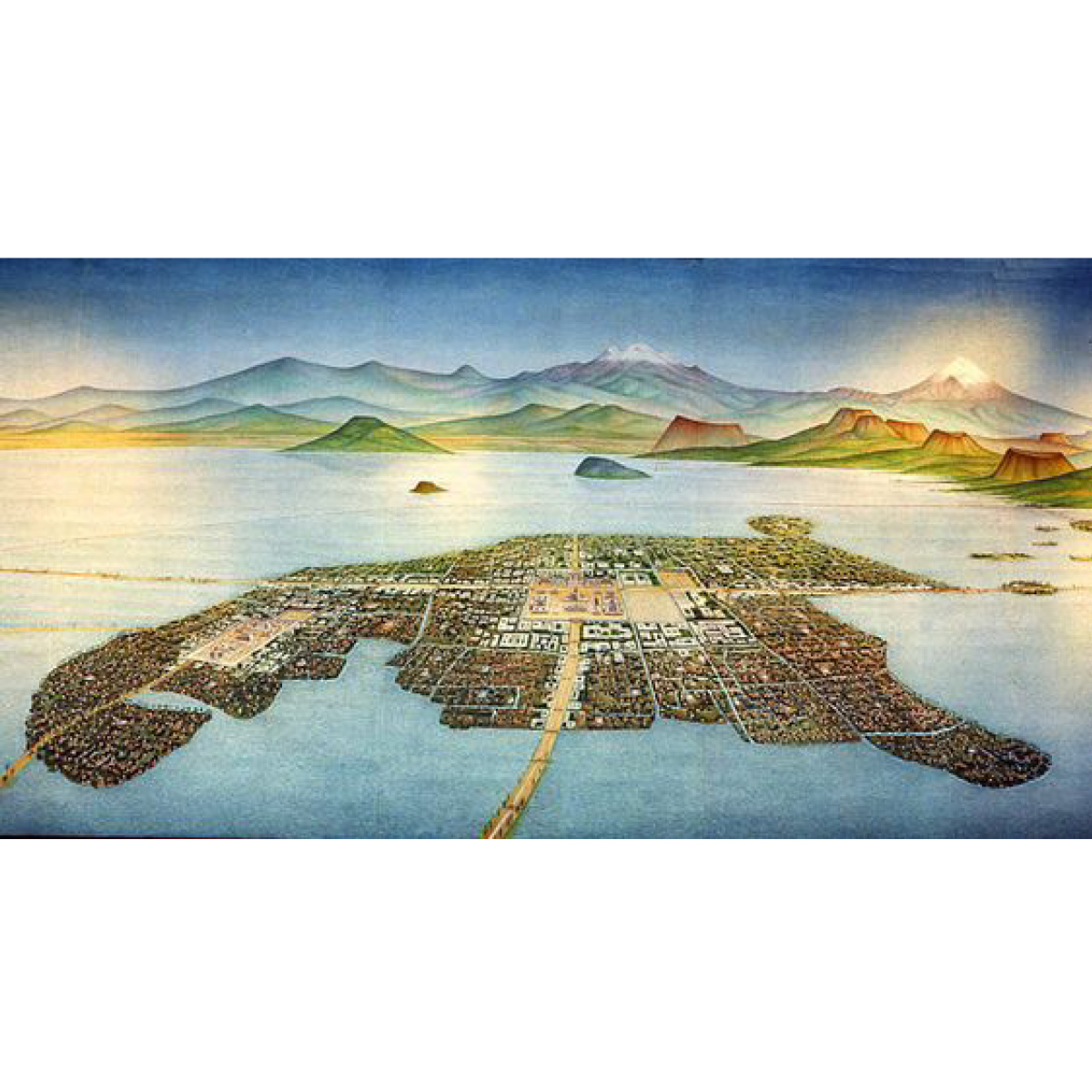
Lake Texcoco was a natural lake within the “Anahuac” or the Valley of Mexico. An indicator of human presence throughout history, the most prominent of the Mexican civilizations were formed around Lake Texcoco. It is believed that the lake disappeared and re-formed at least 10 times in the last 30,000 years.1 In order to control flooding, most of the lake was drained by the Spanish in the 17th century.
Tenochtitlán, in the heart of what is now Mexico City, was the largest altépetl and capital of the Aztec Empire. It was located on an artificial island in the middle of Lake Texcoco, a strange place for any capital, ancient or modern. On the outskirts of the lake stands an even older cultural complex, the ancient civilization of Teotihuacan, known for the most architecturally significant Mesoamerican. The later Aztecs of Tenochtitlán saw these magnificent ruins and claimed a common ancestry with the Teotihuacanos, modifying and adopting aspects of their culture.2
Nowadays, the area along with the Aztec’s massive canal systems are long drained. The only remnants of ancient Lake Texcoco have turned into a major tourist attraction around the area of Xochimilco, showcasing -among others- the ancient Mexican version of a polder system, through a network of flower-perfumed canals. The traditional chinampas (floating gardens) that once fed the great nation are smaller, but still here; the brightly painted trajineras (flat-bottomed boats) may now come equipped with engines, but they are still festively decorated, and many carry troupes of mariachis and offer relaxed "restaurant" service.3
Despite the drainage issues, water is still present around Lake Texcoco, bringing ancient cultures into life as the civilization of Teotihuacan is constantly revealed due to soil erosion by the high tides. Mexico City is a contemporary paradox: sinking and running out of water simultaneously. At the same time, the ancient lake is reclaiming parts of the scrapped airport in the greater region of Mexico City, leading the dream of restoring the landscape to its former glory.
← Back to Lexicon
Tenochtitlan, City of Aztecs in Ancient Mexico, in the middle of lake Texcoco.
- https://en.wikipedia.org/wiki/Lake_Texcoco
- https://en.wikipedia.org/wiki/Teotihuacan
-
https://www.viator.com/Mexico-City/d628
A phenomenon that occurs when due to human activities, a species has access to more nutrients than normal, causing a bloom in population. This leads to an imbalance in the ecosystem that is detrimental to other species.
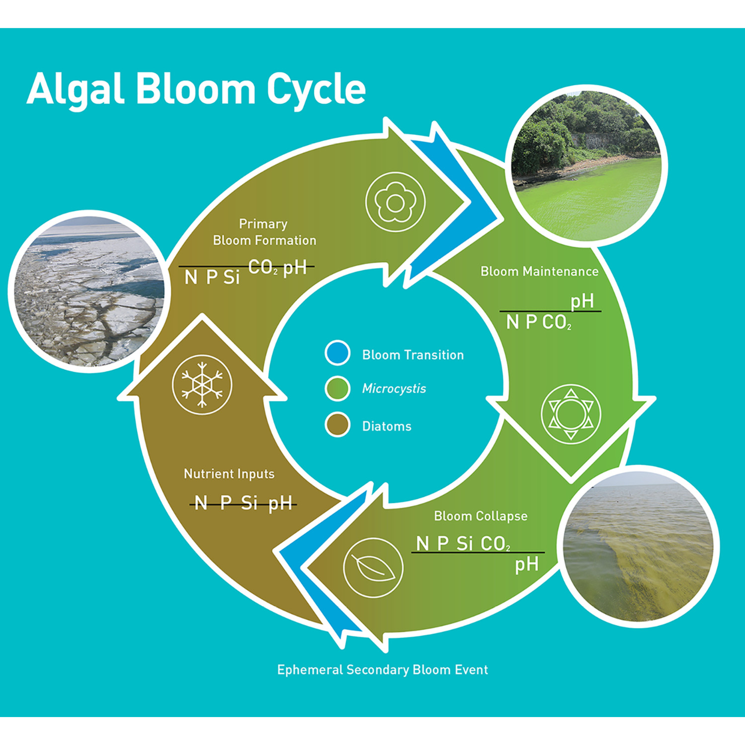
The Algae Bloom, in particular, is one resulting from cultural eutrophication, where the two main contributors of minerals and nutrients into the water are raw sewage and agriculture. However, any usage including recreational use can contribute to this process and is one that has occurred historically. Eutrophication, most commonly the accumulation of phosphate and nitrate, occurs naturally and any human presence has meant the existence of cultural eutrophication. Say in the medieval era, the effects of this accumulation may have been no less than it is now, but a change did occur in that the effects are no longer localized and the Algae Blooms are being seen at a global scale. This is partially due to densification of population and industrial fertilizer use, however of note is the movement of nutrients in the form of food which also has a water amount attached in terms of production. Beyond the globalizing nature of agriculture, animal husbandry contributes to this process in the form of animal sewage along with any fertilizers used to produce any feed, most of which ends up in the water cycle.
As water tends to end up in the ocean, coastal and delta areas tend to be the most impacted by Algae Blooms, but areas with low water exchange like an Endorheic Basin are also particularly susceptible. Additionally, with the fracturing of the water cycle through dams, sewers, and globalized sources of phosphorus like the Kola Peninsula, the effects and contributions to Algae Blooms can reach far inland. However, cultural eutrophication in itself is a natural part of human existence and phenomenon such as the “Red Tide” are from extreme cases resulting from an incomplete biogeochemical water cycle.
← Back to Lexicon
Seasonal bloom cycle of a cyanobacteria, Microcystis, that is prevalent in freshwater
Sources: Wilhelm, Steven W., George S. Bullerjahn, and R. Michael L. McKay. "The Complicated and Confusing Ecology of Microcystis Blooms." mBio 11.3 (2020): e00529-20. Web. 03 May. 2021.
Sources: Wilhelm, Steven W., George S. Bullerjahn, and R. Michael L. McKay. "The Complicated and Confusing Ecology of Microcystis Blooms." mBio 11.3 (2020): e00529-20. Web. 03 May. 2021.
- Wassmann, Paul. (2005). Cultural eutrophication: perspectives and prospects. Drainage Basin Inputs and Eutrophication: An Integrated Approach.
Wetlands refers to a broad category of landscapes and they are created through a variety of mechanisms. Dependings on the rate of water flow, the salinity, and the quantity of decomposing plants they may be swamps, bogs, marshes or fens.
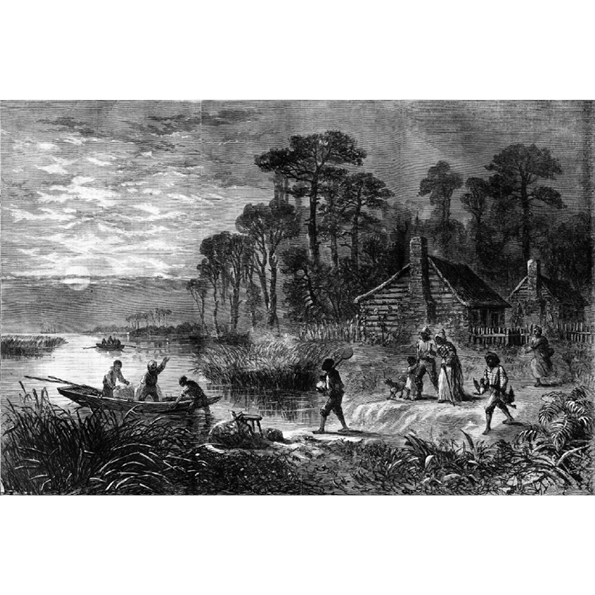
Wetlands are one of the few wildernesses left in many countries. Due to their definition by local ground condition, rather than climate or remoteness, they are often near to human occupation. As a result they have often been used as places to hide, in the USA’s Great Dismal Swamp populations of escaped slaves called Maroons formed communities, independent of the American state that sought their capture. In Iraq, the Mesopotamian Marshes served as a base for an insurrection against the Hussein regime. Today the marshes of Iraq and the swamps of America are still considered places distant from the reach of the central government.
There have been many attempts to bring the wetlands under control, trying to make them habitable or to exploit their resources. Bogs and marshes are defined by their peat soil, a common fuel in contemporary and historically less developed societies. Swamps are often rich sources of timber, George Washington made much of his money through the exploitation of the Great Dismal Swamp for the timber trade. The key components of the wetlands, that is the wet -water-, and the land, are also of value. The water useful for agricultural irrigation in drier climates with estuary marshes, and the land valuable for real estate. Washington’s original business plan before settling on the timber trade was to produce land for sale.
Through draining the wetlands, the state can also attempt to control its residents. Hussein infamously attempted to drain the marsh in response to the insurgency, and the Great Dismal Swamp is much reduced from its original size. Once a wetland is drained, its land can be indistinguishable from other land. The process of converting wetlands into real estate is called poldering. The process is simply one of draining water from the wetlands quicker than it enters. First drainage is improved through the digging of ditches, if this is not enough dijks can be added to prevent water from entering the area, and water can be pumped outside the polder. Much of the Netherlands is made from reclaimed wetlands. However this system must be carefully maintained, its failure will result in catastrophe. Both the great North Sea flood of 1953, and the flooding of New Orleans during Hurricane Katrina in 2005 demonstrate the enormous destruction that will occur when control is lost and the wetland’s drainage fails.
← Back to Lexicon
An admirable view of the desolation which surrounds the[ir] homes ... and the heartiness and energy with which they make their way to freedom upon the slightest opportunity
Sources: Harper’s Weekly, April 9th, 1864
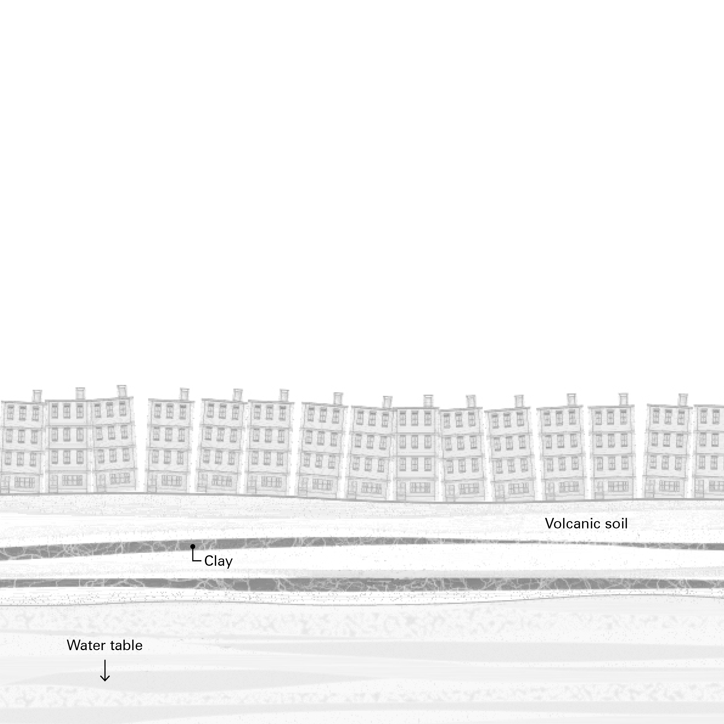
Subsidence is the sudden sinking or gradual downward settling of the ground's surface with little or no horizontal motion. It may be caused by natural processes or by human activities. The former includes aquifer-system compaction, drainage of organic soils, underground mining, hydro compaction, natural compaction, sinkholes, and thawing permafrost. Human activities include sub-surface mining or extraction of underground fluids, e. g. petroleum, natural gas, or groundwater.
Land subsidence is a global problem. Most cases are driven by the exploitation of groundwater by human activities to provide water for agriculture, industries, and daily water consumption in a city. There are profound problems that associated with the exploitation of groundwater such as, land subsidence, an increase of energy required to pump deeper well, a higher concentration of natural and manmade pollutants in the aquifers, saltwater intrusion, disrupted water ecosystem habitat, severe weather condition from the increase of precipitation, and to some extend impacting the local climate.
Mexico City was initially surrounded by Lake Texcoco and at the end of the 19th century, the city successfully drained the lake basin through the Grand drainage canal to the city of Tequixquiac. This effort of flood protection collectively sends surface water out of the city while extracting groundwater causes not enough natural water left to recharge the aquifer and resulted in the occurrence of land subsidence. Subsidence not only exposes new areas to flooding but also diminished the capacity of the Grand canal until it could no longer drain using gravity alone and later need to develop pump systems and deep drainage system.
In 2017, a woman named Maria Teresa has her apartment sink into the ground during an earthquake in Mexico City. The problem arises when insurance companies look for the cause of this collapse either it's by the earthquake or groundwater extraction. The answer could determine whether or not Maria Teresa and others like her will become homeless because subsidence-related damage is uninsurable in Mexico City while there is a robust insurance plan for earthquake-related disasters. The city has no plan to stop groundwater extraction, therefore subsidence is inevitable. From an insurance perspective, subsidence is not a disaster but a plan. Mexico City's failure to manage the surface water as a resource and aquifer overdraft now resulted in the city problem of flooding, scarcity of clean water for consumption, and other cases like Maria Teresa.
← Back to Lexicon
Mexico City drinking itself to the ground
Sources: “Why Is Mexico City Sinking?” Mexican Routes Visit and Explore Mexico, August 15, 2020. https://mexicanroutes.com/why-is-mexico-city-sinking/.
Sources: “Why Is Mexico City Sinking?” Mexican Routes Visit and Explore Mexico, August 15, 2020. https://mexicanroutes.com/why-is-mexico-city-sinking/.
- Kiley Fellow Lecture: Seth Denizen, "Thinking Through Soil: Case Study from the Mezquital Valley", YouTube Video, 1:14:58, “Harvard GSD,” September 22, 2020, https://www.youtube.com/watch?v=klJb9M-_3cg.
- Moran, Tara, Janny Choy, and Carolina Sanchez. “Understanding California's Groundwater.” Water in the West. Stanford University. Accessed May 2, 2021. https://waterinthewest.stanford.edu/groundwater/overdraft/.
- Lewis, Alan Christopher & Torres, Janet. (2013). “The Ghosts of Lake Texcoco Still Haunting Mexico City.” The Drop, Water Management and Hydrological Science Program, Texas A&M University, Volume 5, Fall 2013.