The water fountains, meaning a source of spring, are architectural elements that spring water into a basin or jets it into the air to supply water for several purposes. Initially, these fountains remained purely functional by being directly connected with springs, aqueducts, or reservoirs to provide water through gravity for various activities like drinking, bathing, washing, or firefighting. With the invention of indoor plumbing by the end of the 19th century, urban water fountains transformed into purely decorative elements attracting tourists and operating through mechanised systems. With the continuous improvements and innovations in the domain of water supply, the historic fountains from the 18th and 19th centuries were usually built to celebrate water and the technology associated with it. These historic fountains were expressions of Baroque art, and the bronze sculptures in these fountains would personify Rivers and Gods in combination with the city’s cultural significance. These memorial fountains were often designed by famous artists of their era to commemorate certain events in history.
The most prominent historic water fountains are the ‘Wallace Fountains’ in Paris which were constructed after the siege of Paris which had destroyed the aqueducts, contaminated the water and considerably increased the cost of drinking water. Sir Richard Wallace built these fountains in an attempt to provide clean drinking water to everyone and to decrease the reliance on alcoholic beverages, which were way cheaper and became a substitute for water. Fountains as a source of water supply for the population of Vienna were constructed during Roman times. Vienna today has more than 1000 drinking water fountains and about 55 monumental fountains intricately and artistically designed, situated in central squares and overseen by Wiener Wasser and the Stadtgärten. These are the old town drinking fountains, modern 3-meter high stainless-steel drinking fountains, and artistically designed drinking fountains. Apart from providing water, some of these fountains also provide cooling through spray mist. The city of Vienna has also created an interactive mobile application showing the locations of all water fountains on the city map. Similarly, Mexico City’s Water System, in 2015, inaugurated a network of 230 drinking-water fountains installed in public spaces across the city. Mexicans consume more bottled water per person compared to any other country in the world, and therefore, this system is an initiative to curb their dependence on bottled water. An interactive website informs the residents and tourists in Mexico about the locations and quality of drinking water in these fountains throughout the city.
← Back to Lexicon
Cast-iron Wallace Fountain painted in green and equipped with tin cups to provide drinking water.
Sources: “History of the collection”, The Wallace Collection, accessed May 03, 2021, https://www.wallacecollection.org/art/collection/history-collection/
Sources: “History of the collection”, The Wallace Collection, accessed May 03, 2021, https://www.wallacecollection.org/art/collection/history-collection/
- “Viennese Water - free of charge from drinking fountains”, Vienna Insight, June 26, 2018, https://vienna-insight.at/blog/2018/07/31/viennese-water-free-charge-drinking-fountains/
- “Mexico City's Drinking Water Fountains: Geo-Mexico, the geography of Mexico”, Geo, April 17, 2018, https://geo-mexico.com/?p=13115
-
“Fountain”, Wikipedia, accessed May 03, 2021, https://en.wikipedia.org/wiki/Fountain
-
“Wallace Fountain”, Wikipedia, accessed May 03, 2021, https://en.wikipedia.org/wiki/Wallace_fountain

Wetlands refers to a broad category of landscapes and they are created through a variety of mechanisms. Dependings on the rate of water flow, the salinity, and the quantity of decomposing plants they may be swamps, bogs, marshes or fens.
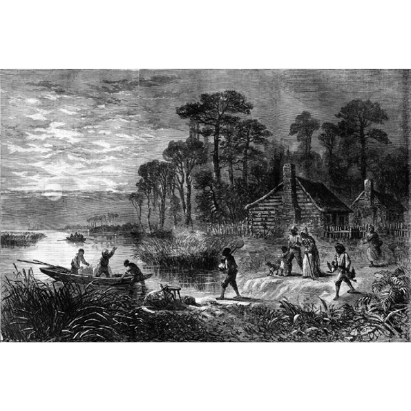
Wetlands are one of the few wildernesses left in many countries. Due to their definition by local ground condition, rather than climate or remoteness, they are often near to human occupation. As a result they have often been used as places to hide, in the USA’s Great Dismal Swamp populations of escaped slaves called Maroons formed communities, independent of the American state that sought their capture. In Iraq, the Mesopotamian Marshes served as a base for an insurrection against the Hussein regime. Today the marshes of Iraq and the swamps of America are still considered places distant from the reach of the central government.
There have been many attempts to bring the wetlands under control, trying to make them habitable or to exploit their resources. Bogs and marshes are defined by their peat soil, a common fuel in contemporary and historically less developed societies. Swamps are often rich sources of timber, George Washington made much of his money through the exploitation of the Great Dismal Swamp for the timber trade. The key components of the wetlands, that is the wet -water-, and the land, are also of value. The water useful for agricultural irrigation in drier climates with estuary marshes, and the land valuable for real estate. Washington’s original business plan before settling on the timber trade was to produce land for sale.
Through draining the wetlands, the state can also attempt to control its residents. Hussein infamously attempted to drain the marsh in response to the insurgency, and the Great Dismal Swamp is much reduced from its original size. Once a wetland is drained, its land can be indistinguishable from other land. The process of converting wetlands into real estate is called poldering. The process is simply one of draining water from the wetlands quicker than it enters. First drainage is improved through the digging of ditches, if this is not enough dijks can be added to prevent water from entering the area, and water can be pumped outside the polder. Much of the Netherlands is made from reclaimed wetlands. However this system must be carefully maintained, its failure will result in catastrophe. Both the great North Sea flood of 1953, and the flooding of New Orleans during Hurricane Katrina in 2005 demonstrate the enormous destruction that will occur when control is lost and the wetland’s drainage fails.
← Back to Lexicon
An admirable view of the desolation which surrounds the[ir] homes ... and the heartiness and energy with which they make their way to freedom upon the slightest opportunity
Sources: Harper’s Weekly, April 9th, 1864

Allegory is a literary device used in numerous forms of art to reveal the hidden meaning of real-world issues and occurrences through a discreet curtain of a symbolic character, place or event.
The allegories of rivers have been in existence since the post-Hellenistic-Age Romans, who personified rivers as mythical figures capable of bringing life and prosperity and at times, capable of wreaking havoc through the power of floods. Romans personified rivers in their artworks as a bull or a man with a bullhead, similar to the Greek myth about the god of rivers- the Achelous, who was defeated by Hercules for the hand of the water nymph Deianeira. Hercules ripped off a horn of Achelous and offered it to Deianeira, who filled it with fruits calling it a 'cornucopia'- another river analogy that turns up repeatedly. Gradually, the rivers became symbolic as bearded reclining men and springs as standing female nymphs throughout the Roman era where long beards, flowing hair with reed crowns, and robes holding urns as origins of the river provided the perception of flowing water. The representation of major rivers - the Tiber, Nile, Euphrates, Tigris, Danube and Rhine - were commonly featured in artworks and coins. The famous painting 'The Four Continents', also known as 'The Four Rivers of Paradise', represents the female personifications of Europe, Asia, Africa and America sitting with the personifications of their respective major rivers – the Danube, the Ganges, the Nile and the Río de la Plata. Vienna's Danube is depicted in the column of Trajan in Rome as a personified male somberly looking over the Roman army as they cross the river. The sculptures in Vienna's water fountains are often personifications of its springs and rivers to celebrate water and its associated technology.
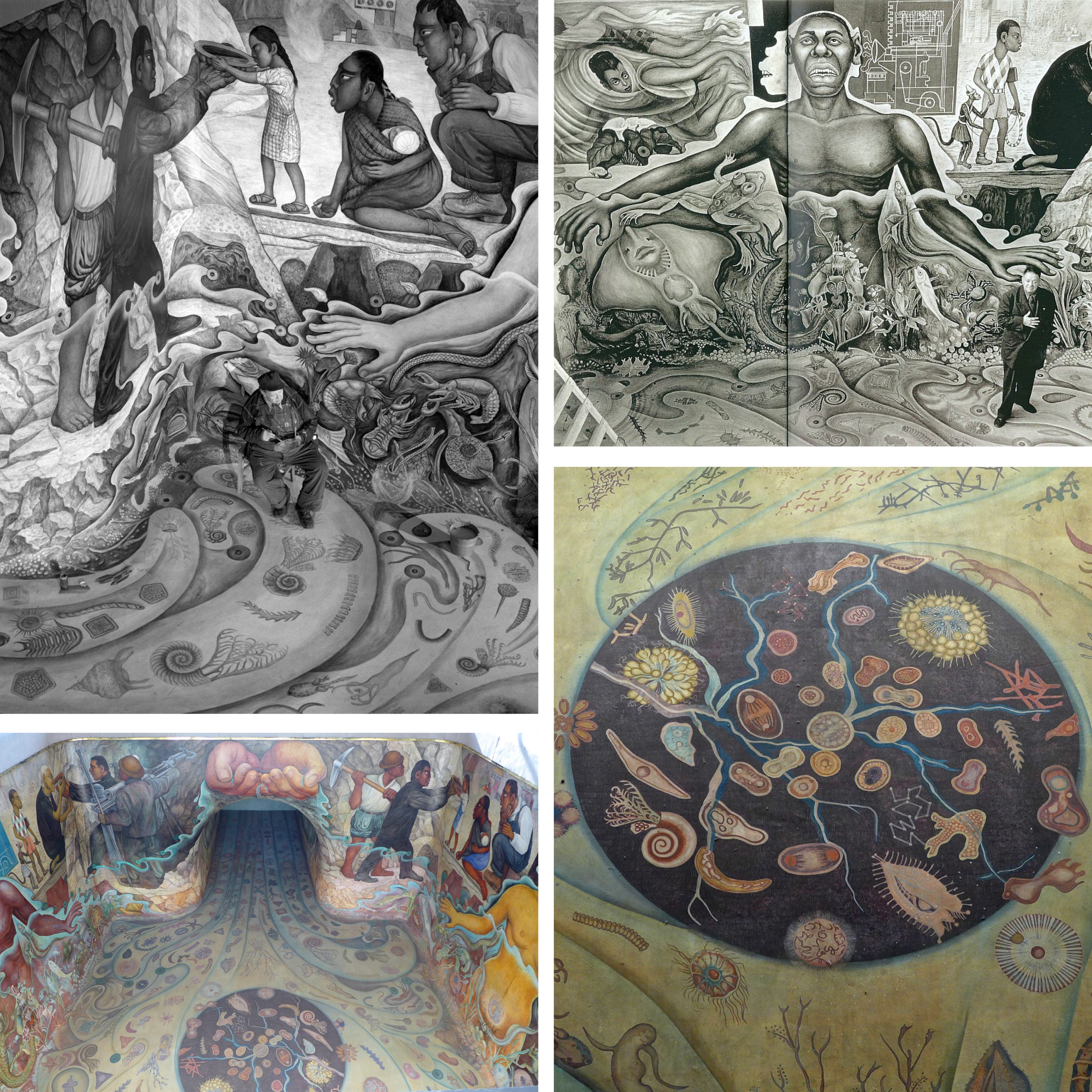
Another allegory of water as an originating element of life on earth and its abiogenesis is observed in 1951, in Rivera's mural of Cárcamo de Dolores. The mural inspired by the theories of Alexander Ivanovich Oparin, a Soviet biochemist, represents the origin of life through various organisms, first men inspired by Olmec art, the importance of workers and technology in providing water to the city, and its importance in daily lives.
← Back to Lexicon
Images of Diego Rivera’s mural ‘The Origin of Life’ for Cárcamo de Dolores.
Sources: “Cárcamo de Dolores”, Wikipedia, July 26, 2020, https://es.wikipedia.org/wiki/C%C3%A1rcamo_de_Dolores
Sources: “Cárcamo de Dolores”, Wikipedia, July 26, 2020, https://es.wikipedia.org/wiki/C%C3%A1rcamo_de_Dolores
- “Rivers of art: Ancient Rome”, River Ecology and Research, September 15, 2016, https://paulhumphriesriverecology.wordpress.com/2016/09/15/rivers-of-art-ancient-rome/
- “The Four Continents”, Wikipedia, March 25, 2021, https://en.wikipedia.org/wiki/The_Four_Continents
- “Departure across the Danube”, Omeka RSS, accessed May 03, 2021, http://omeka.wellesley.edu/piranesi-rome/exhibits/show/column-for-trajan/departure-across-the-danube
-
“Cárcamo de Dolores”, Wikipedia, July 26, 2020, https://es.wikipedia.org/wiki/C%C3%A1rcamo_de_Dolores

Legend has it, that -precisely- on May 24, 1065 CE, the Aztecs ventured on an epic migration from their ancestral homeland, Aztlan (“Place of Reeds” or “Place of Egrets”), to the shores of Lake Texcoco, in central Mexico. There, by forming another altépetl, they founded the city of Tenochtitlan, which in time spawned the vast Aztec Empire, famously encountered by Hernan Cortez several hundred years later. The altépetl (plural altepeme) was the local ethnical-political-territorial entity or “city-state” in Mesoamerican societies. The indigenous identity during the Aztec Empire was defined by the altépetl. The word actually combines the Nahuatl word for “water”, ātl, with tepētl, meaning “mountain”, anchoring civilization in a clearly defined territory.1 The Mexican culture and origins are inextricably tied to the elements of earth and water.
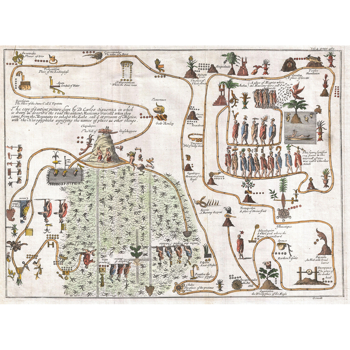
This unusual 1704 map, drawn by Giovanni Francesco Gemelli Careri, is the first published representation of the legendary Aztec migration from Aztlan, a mysterious paradise somewhere to the northwest of Mexico, to Chapultepec Hill. The road that the ancient Mexicans travelled when they came from the mountain on the lake in order to inhabit Lake Texcoco, is drawn and described with the Hieroglyphics signifying the names of content and places. Aztlan appears here in the upper right corner also as a lake, with a mountain and a palm tree. The progression meanders along many paths and digressions to finally arrive to the upper right quadrant, where we can discern a hill upon which rests a gigantic Grasshopper. This is Chapultepec, known nowadays as Mexico City.2
This unusual 1704 map, drawn by Giovanni Francesco Gemelli Careri, is the first published representation of the legendary Aztec migration from Aztlan, a mysterious paradise somewhere to the northwest of Mexico, to Chapultepec Hill. The road that the ancient Mexicans travelled when they came from the mountain on the lake in order to inhabit Lake Texcoco, is drawn and described with the Hieroglyphics signifying the names of content and places. Aztlan appears here in the upper right corner also as a lake, with a mountain and a palm tree. The progression meanders along many paths and digressions to finally arrive to the upper right quadrant, where we can discern a hill upon which rests a gigantic Grasshopper. This is Chapultepec, known nowadays as Mexico City.2
Gemelli Map of the Aztec Migration from Aztlan to Chapultepec.