Lake Texcoco was a natural lake within the “Anahuac” or the Valley of Mexico. An indicator of human presence throughout history, the most prominent of the Mexican civilizations were formed around Lake Texcoco. It is believed that the lake disappeared and re-formed at least 10 times in the last 30,000 years.1 In order to control flooding, most of the lake was drained by the Spanish in the 17th century.
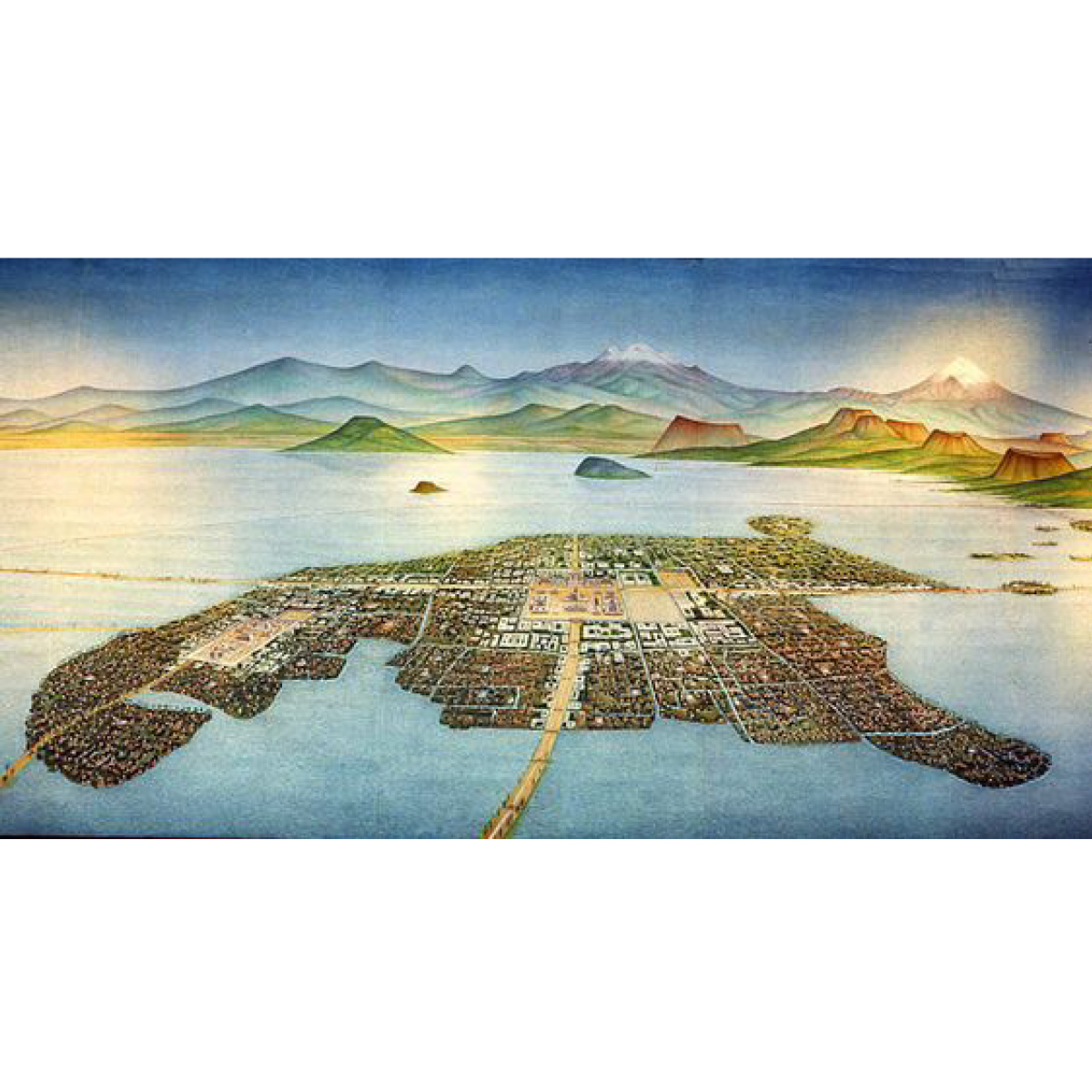
Tenochtitlán, in the heart of what is now Mexico City, was the largest altépetl and capital of the Aztec Empire. It was located on an artificial island in the middle of Lake Texcoco, a strange place for any capital, ancient or modern. On the outskirts of the lake stands an even older cultural complex, the ancient civilization of Teotihuacan, known for the most architecturally significant Mesoamerican. The later Aztecs of Tenochtitlán saw these magnificent ruins and claimed a common ancestry with the Teotihuacanos, modifying and adopting aspects of their culture.2
Nowadays, the area along with the Aztec’s massive canal systems are long drained. The only remnants of ancient Lake Texcoco have turned into a major tourist attraction around the area of Xochimilco, showcasing -among others- the ancient Mexican version of a polder system, through a network of flower-perfumed canals. The traditional chinampas (floating gardens) that once fed the great nation are smaller, but still here; the brightly painted trajineras (flat-bottomed boats) may now come equipped with engines, but they are still festively decorated, and many carry troupes of mariachis and offer relaxed "restaurant" service.3
Despite the drainage issues, water is still present around Lake Texcoco, bringing ancient cultures into life as the civilization of Teotihuacan is constantly revealed due to soil erosion by the high tides. Mexico City is a contemporary paradox: sinking and running out of water simultaneously. At the same time, the ancient lake is reclaiming parts of the scrapped airport in the greater region of Mexico City, leading the dream of restoring the landscape to its former glory.
← Back to Lexicon
Tenochtitlan, City of Aztecs in Ancient Mexico, in the middle of lake Texcoco.
- https://en.wikipedia.org/wiki/Lake_Texcoco
- https://en.wikipedia.org/wiki/Teotihuacan
-
https://www.viator.com/Mexico-City/d628
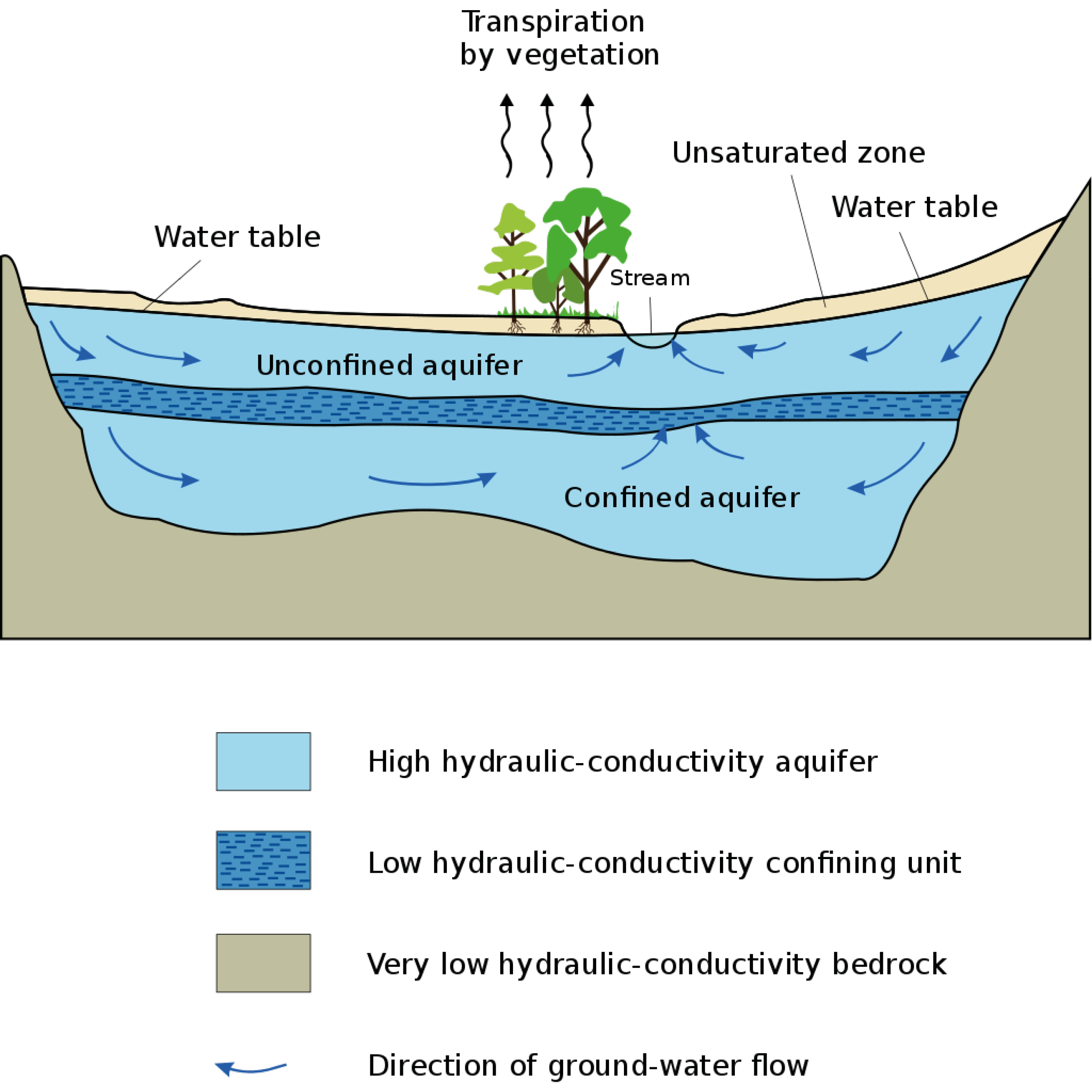
Marchfeld is an example of an aquifer in that it is a body of permeable rock can contain or transmit groundwater. The aquifer’s water movement depends on the permeability of the aquifer material. In some permeable materials, groundwater can move several meters in a day. In extreme cases, the water moves only a few centimeters in a century. Groundwater moves very slowly through relatively impermeable materials, such as clay and shale. If the groundwater is between layers of these impermeable materials, it is confined under pressure to become an artesian aquifer. An aquifer’s water, like Marchfelds, moves slowly towards lower lying places and is eventually discharged from springs, seeps into streams, or is withdrawn from the ground by wells.
97% of the earth's freshwater is stored in aquifers and groundwater is the primary source of drinking water for more than 1.5 billion people. Some of the largest cities in the developing world, such as Jakarta, Dhaka, Lima, and Mexico City, depend on aquifers for almost all their water. In rural areas, where centralized water supply systems are undeveloped, groundwater is typically the source of water.
The typical methods normally used to conceal garbage and other waste, such as landfills, septic tanks, and sewers, have become the major conduits of chemical pollution of groundwater. When aquifers are polluted, it is almost impossible to flush out contaminants from the clay layers where much of the aquifer’s water may be stored. With increases in urban population, the demand on groundwater is increasing and causing stress on the aquifers.
Many major aquifers are being drained faster than their natural rate of recharge. In some cases, areas like Marchfeld are being exploited at higher rates than previously done in the past. Marchfeld once provided water for agricultural uses but is now shifting to factory use. On average, a ton of water used in industry generates about 70 times as much profit as the same amount of water used to grow grain. Climate change has caused droughts in many aquifer areas. With the growing population and climate change, aquifers require heavy monitoring to keep the water level in balance.
Aquifer cross section.
Sources: “Aquifer,” Wikipedia (Wikimedia Foundation, April 23, 2021), https://en.wikipedia.org/wiki/Aquifer.
Sources: “Aquifer,” Wikipedia (Wikimedia Foundation, April 23, 2021), https://en.wikipedia.org/wiki/Aquifer.
- Thomas R Gatliffe, “Calibration and Reliability in Groundwater Modelling: Coping with Uncertainty,” Technometrics 44, no. 1 (2002): pp. 84-85, https://doi.org/10.1198/tech.2002.s655.
-
“Aquifers and Groundwater,” Aquifers and Groundwater, accessed March 3, 2021, https://www.usgs.gov/special-topic/water-science-school/science/aquifers-and-groundwater?qt-science_center_objects=0#qt-science_center_objects.
If you want to look for a machine that is responsible for the flooding and land subsidence in various cities, the submersible pump indeed is one of the tools which is contributing to the exploitation of groundwater extraction for drinking and irrigation.
Extracting water from the aquifers is not a bad thing. Wells was invented to get access to clean water, especially for areas that have no access to proper and clean surface water. Groundwater extraction can be safely extracted from the aquifer if it is balanced with the recharge rate through a natural or artificial process. Subsidence occurs when the water table in the aquifer is reduced from the rock that supports more weight when saturated (Overdrafting).
A contemporary submersible pump can extract up to 283 cubic meters of water/hour. meaning in one hour one of these types of pumps could provide daily water consumption for up to 900 people (300 liters/day). State of art submersible pump can be equipped with frequency drive operation to control the output of the pump. Therefore, it can extract the amount of water that the well could give and avoid over-pumping.
In Mexico City, a similar type of pump is used for water supply, six groundwater extraction wells collectively extracting almost 600 liters per second (around 300 cubic meters/hour/pump) and supply water to the entire municipality. Reliance on groundwater extraction to supply clean water for 20 million people has dropped water tables up to 35 meters in the last 40 years in some areas in Mexico City.
← Back to Lexicon
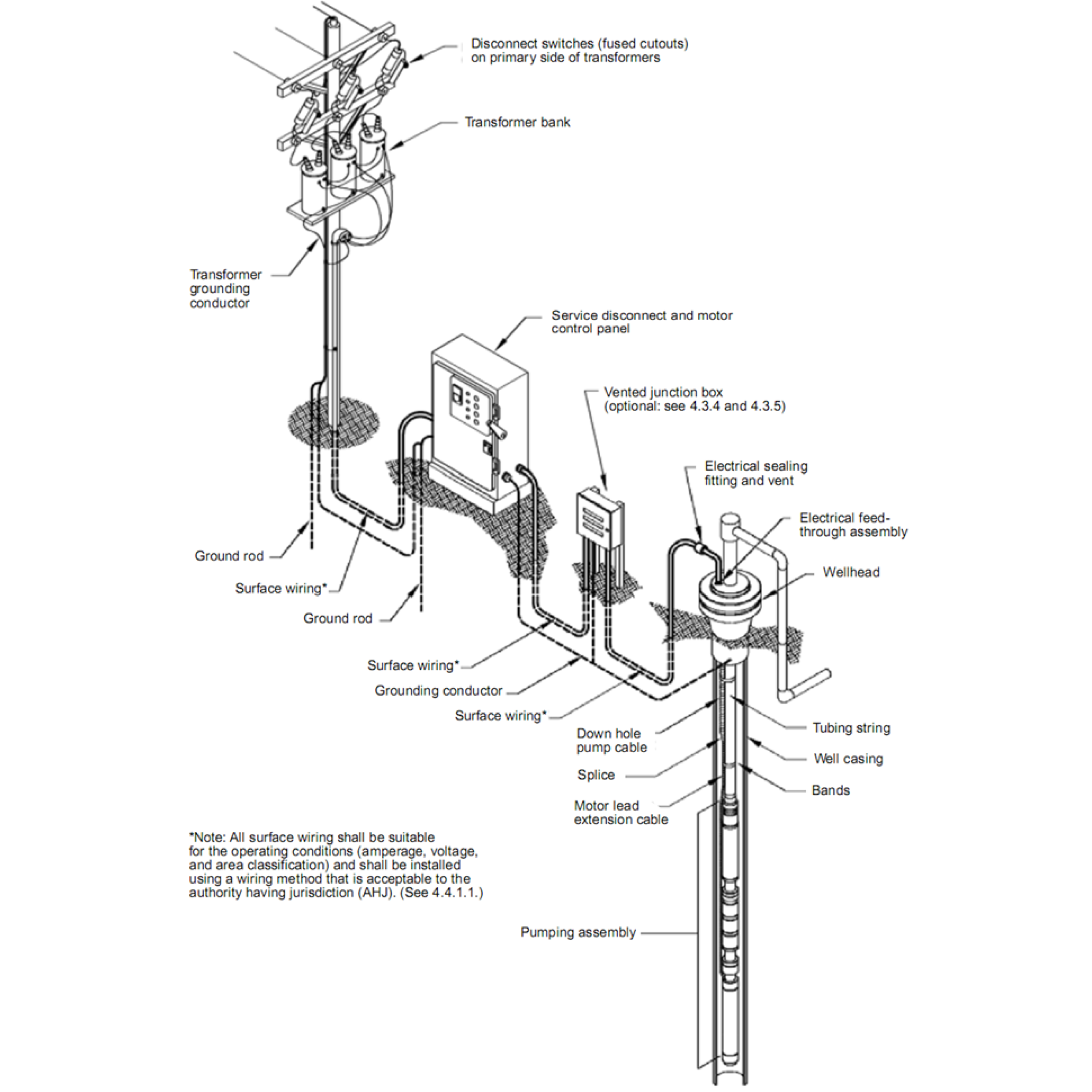
Components of an Electrical Submersible Pumping System.
Sources: Fetoui, Islam. “Submersible Pump System Overview: Main Surface and Downhole Components.” Production Technology, September 8, 2017. https://production-technology.org/submersible-pump-overview/.
Sources: Fetoui, Islam. “Submersible Pump System Overview: Main Surface and Downhole Components.” Production Technology, September 8, 2017. https://production-technology.org/submersible-pump-overview/.
- Kiley Fellow Lecture: Seth Denizen, "Thinking Through Soil: Case Study from the Mezquital Valley", YouTube Video, 1:14:58, “Harvard GSD,” September 22, 2020, https://www.youtube.com/watch?v=klJb9M-_3cg.
- The advantage of frequency drive operation in submersible pumps, Grundfos Video, 5:55, “Grundfos”, accessed May 2, 2020, https://www.grundfos.com/solutions/learn/ecademy/all-courses/the-sp-submersible-pump/the-advantages-of-frequency-drive-operation-in-submersible-pumps
- “Well.” Wikipedia. April 25, 2021. https://en.wikipedia.org/wiki/Well.
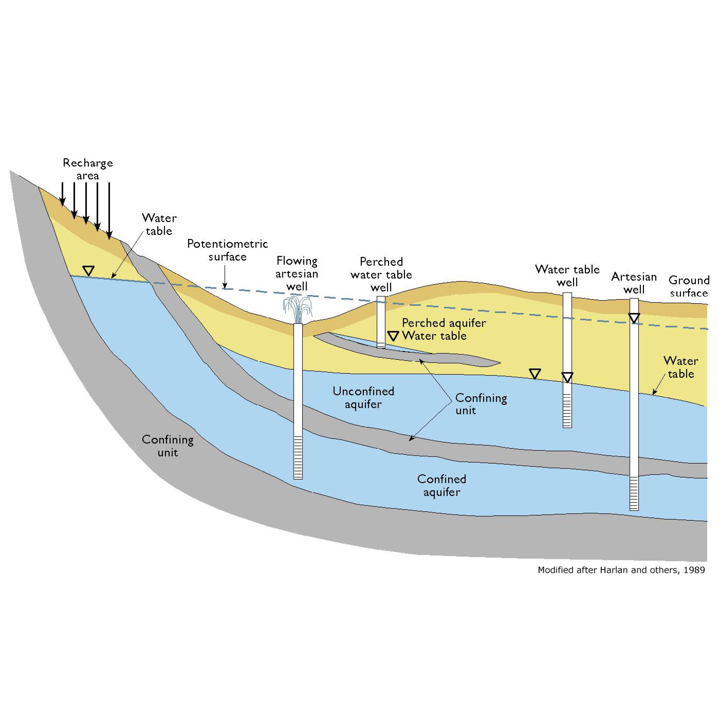
First a water source needs to be found and then it can be extracted through countless mechanisms. This can be at small or large scales even with the same techniques such as accessing aquifers through wells and pumps by individual households in Jakarta or the Mexico City Water System Wells (SACM). In general this is in order to access drinking water although it can be done for irrigation uses.
Springs are readily accessible sources of water, but Water Mains are established when the source is not yet flowing or flowing in another direction. In the case of Mexico City, the drinkable water of the Endorheic Basin there largely begins at the Sierra Chichinautzin due to the large amount of basalt rock that allows for the water to enter the ground and begin its filtration process. At the other end the Xochimilco springs is an important site for the basin and many of the most productive wells are located here. Some of these make up the 549 wells in the SACM which are also supplemented by the Lerma System wells that bring in water from past the Sierra Madre Occidental from other valleys.
Even further than that the Cutzamala System, taps the Cutzamala River that is part of the Balsas Basin and moves it 60-154km horizontally and over 1000m vertically to bring it to the Valley of Mexico while tapping numerous other sources on the way. The system was initially developed in 1930 as a hydropower project called the Miguel Aleman Hydroelectric System but then it was adapted to the Cutzamala System and 102 pumping stations, 17 tunnels, and 7.5km of canals were planned. Due to the massive scale of this project it was executed in three stages. Now it has eight main reservoirs, six main pumping plants, 322km of canals and tunnels, a water treatment plant, and eight dams. This massively expensive and energy-intensive project has reduced the burden of providing drinking water from the Mexico and Lerma Valley Aquifers and still is the primary focus in infrastructural investments. In 1997, the fourth stage of the project called the Temascaltepec project was to be initiated and was stopped as of now due to the local populations worries about the effects of a tunnel on the springs in the region.
← Back to Lexicon
Aquifer recharged and accessed by different types of wells
Sources: https://cnx.org/resources/91be4f9a9a78064d99ab3028c8c0be2806433e3f/graphics12.jpg
Sources: https://cnx.org/resources/91be4f9a9a78064d99ab3028c8c0be2806433e3f/graphics12.jpg
- National Research Council. 1995. Mexico City's Water Supply: Improving the Outlook for Sustainability. Washington, DC: The National Academies Press. https://doi.org/10.17226/4937.
- Martinez, S., Escolero, O. & Perevochtchikova, M. A comprehensive approach for the assessment of shared aquifers: the case of Mexico City. Sustain. Water Resour. Manag. 1, 111–123 (2015). https://doi.org/10.1007/s40899-015-0010
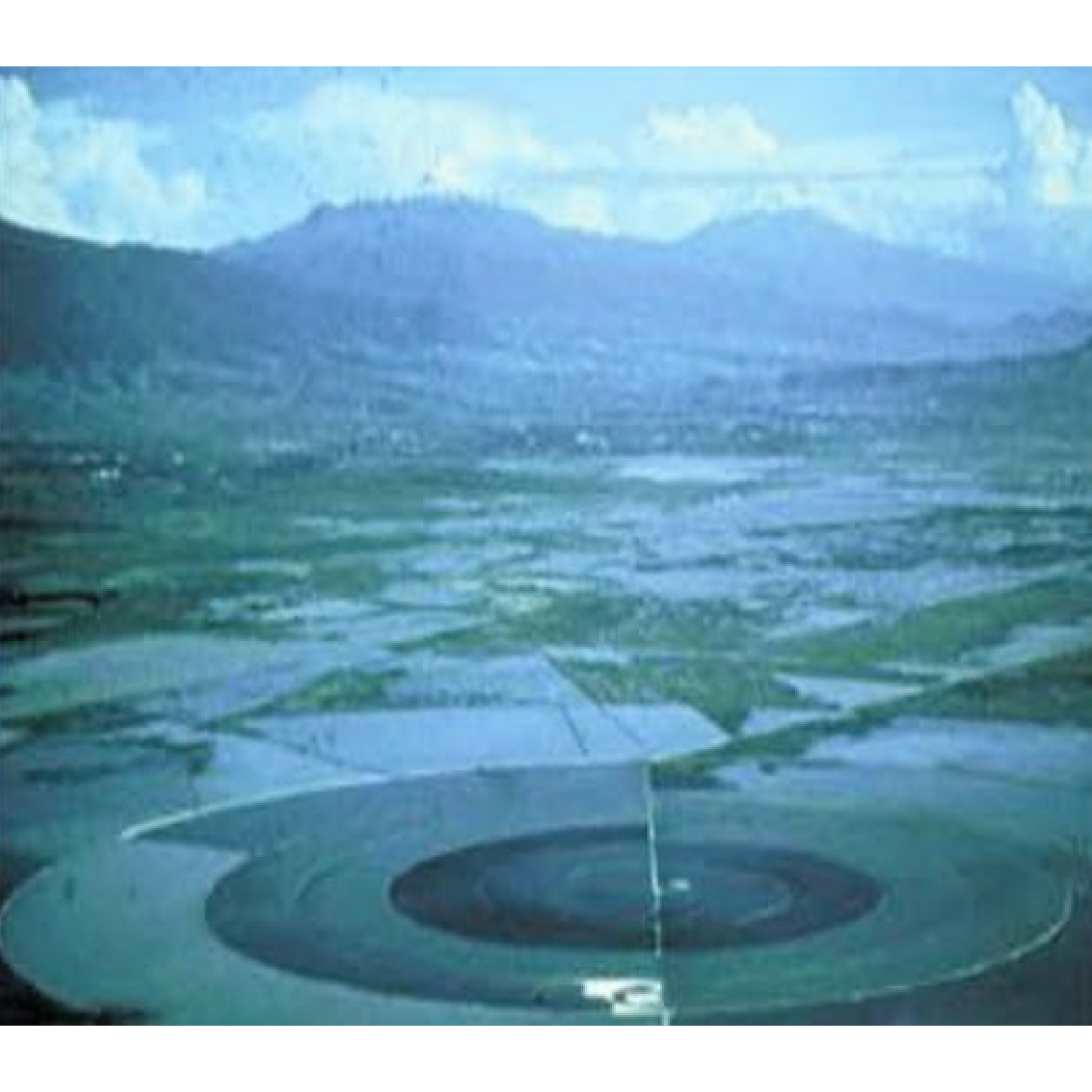
Caracol Ecatepec was built in 1942 by SOSA Texcoco to desalinate the water of Lake Texcoco. Designed by Nabor Carrillo, the retention basin and a desalination plant were located over the drained site of Lake Texcoco.1 The 3,200m in diameter basin was called “the snail” from its short spiral-shaped concrete levee that circles it.1 The water from the lake entered from a pump house on an island in the middle of the basin and was channeled outward and clockwise.1 The channel increases in width while decreases in depth until it becomes too shallow to flow further.1 The water evaporates in the opposite direction.1 This allowed for a predictable collection of 100 tons of salts per day.1 The desalinated water that was extracted was used by the factories nearby.
A lack of understanding of the actual process caused the process to be more expensive than expected. In 1967, Lake Texcoco was further exploited by discovering and cultivating its blue algae. The algae are collected by screens and processed into dry nutritional supplement powder for commercial sale branded "Spirulina Mexicana". In December 1986, SOSA Texcoco went bankrupt from a series of strikes and the slow hand labor forced by its snail shape. In 1991, the company and facilities were sold at a low rate to a collective of investors called Sociedad Anónima de Capital Variable. Sociedad Anónima de Capital Variable tried to negotiate the collective bargaining contracts for manual laborers that were mandated upon SOSA Texcoco by the Madrid administration. In 1991, the Mexican Supreme Court ruled that the old contracts must be honored if any profit-seeking business were to resume operations. This forced Sociedad Anónima de Capital Variableto to fold. The government then liquidated the original deed, voided the worker contracts, and seized the inactive facility as a public asset.
In 2000, Caracol was redeveloped with 13,000 new units of low-income housing and a shopping mall. With the additional development and the informal growing settlement of El Salado nearby, the basin cannot expand.The basin is currently owned by the Mexican government and in use as a reservoir for industrial facilities within Mexico City. It is filled from a junction with the Canal de Sal that runs along the south edge of the facility and connects it to the rest of the Mexico City drainage basin.
← Back to Lexicon
El Caracol in mid-20th century.
Sources: Imen Hamed, “The Evolution and Versatility of Microalgal Biotechnology: A Review,” Wiley Online Library (John Wiley & Sons, Ltd, September 26, 2016), https://onlinelibrary.wiley.com/doi/full/10.1111/1541-4337.12227.
Sources: Imen Hamed, “The Evolution and Versatility of Microalgal Biotechnology: A Review,” Wiley Online Library (John Wiley & Sons, Ltd, September 26, 2016), https://onlinelibrary.wiley.com/doi/full/10.1111/1541-4337.12227.
- Jose Castillo, “Peripheral Landscapes, El Caracol, Mexico City,” Architectural Design 78, no. 1 (2008): pp. 64-67, https://doi.org/10.1002/ad.611.
-
“El Caracol, Ecatepec,” Wikipedia (Wikimedia Foundation, April 10, 2020), https://en.wikipedia.org/wiki/El_Caracol,_Ecatepec.