Lake Texcoco was a natural lake within the “Anahuac” or the Valley of Mexico. An indicator of human presence throughout history, the most prominent of the Mexican civilizations were formed around Lake Texcoco. It is believed that the lake disappeared and re-formed at least 10 times in the last 30,000 years.1 In order to control flooding, most of the lake was drained by the Spanish in the 17th century.
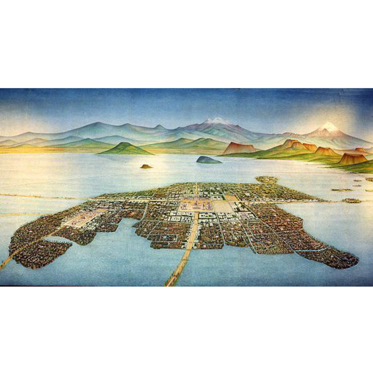
Tenochtitlán, in the heart of what is now Mexico City, was the largest altépetl and capital of the Aztec Empire. It was located on an artificial island in the middle of Lake Texcoco, a strange place for any capital, ancient or modern. On the outskirts of the lake stands an even older cultural complex, the ancient civilization of Teotihuacan, known for the most architecturally significant Mesoamerican. The later Aztecs of Tenochtitlán saw these magnificent ruins and claimed a common ancestry with the Teotihuacanos, modifying and adopting aspects of their culture.2
Nowadays, the area along with the Aztec’s massive canal systems are long drained. The only remnants of ancient Lake Texcoco have turned into a major tourist attraction around the area of Xochimilco, showcasing -among others- the ancient Mexican version of a polder system, through a network of flower-perfumed canals. The traditional chinampas (floating gardens) that once fed the great nation are smaller, but still here; the brightly painted trajineras (flat-bottomed boats) may now come equipped with engines, but they are still festively decorated, and many carry troupes of mariachis and offer relaxed "restaurant" service.3
Despite the drainage issues, water is still present around Lake Texcoco, bringing ancient cultures into life as the civilization of Teotihuacan is constantly revealed due to soil erosion by the high tides. Mexico City is a contemporary paradox: sinking and running out of water simultaneously. At the same time, the ancient lake is reclaiming parts of the scrapped airport in the greater region of Mexico City, leading the dream of restoring the landscape to its former glory.
← Back to Lexicon
Tenochtitlan, City of Aztecs in Ancient Mexico, in the middle of lake Texcoco.
- https://en.wikipedia.org/wiki/Lake_Texcoco
- https://en.wikipedia.org/wiki/Teotihuacan
-
https://www.viator.com/Mexico-City/d628

The water fountains, meaning a source of spring, are architectural elements that spring water into a basin or jets it into the air to supply water for several purposes. Initially, these fountains remained purely functional by being directly connected with springs, aqueducts, or reservoirs to provide water through gravity for various activities like drinking, bathing, washing, or firefighting. With the invention of indoor plumbing by the end of the 19th century, urban water fountains transformed into purely decorative elements attracting tourists and operating through mechanised systems. With the continuous improvements and innovations in the domain of water supply, the historic fountains from the 18th and 19th centuries were usually built to celebrate water and the technology associated with it. These historic fountains were expressions of Baroque art, and the bronze sculptures in these fountains would personify Rivers and Gods in combination with the city’s cultural significance. These memorial fountains were often designed by famous artists of their era to commemorate certain events in history.
The most prominent historic water fountains are the ‘Wallace Fountains’ in Paris which were constructed after the siege of Paris which had destroyed the aqueducts, contaminated the water and considerably increased the cost of drinking water. Sir Richard Wallace built these fountains in an attempt to provide clean drinking water to everyone and to decrease the reliance on alcoholic beverages, which were way cheaper and became a substitute for water. Fountains as a source of water supply for the population of Vienna were constructed during Roman times. Vienna today has more than 1000 drinking water fountains and about 55 monumental fountains intricately and artistically designed, situated in central squares and overseen by Wiener Wasser and the Stadtgärten. These are the old town drinking fountains, modern 3-meter high stainless-steel drinking fountains, and artistically designed drinking fountains. Apart from providing water, some of these fountains also provide cooling through spray mist. The city of Vienna has also created an interactive mobile application showing the locations of all water fountains on the city map. Similarly, Mexico City’s Water System, in 2015, inaugurated a network of 230 drinking-water fountains installed in public spaces across the city. Mexicans consume more bottled water per person compared to any other country in the world, and therefore, this system is an initiative to curb their dependence on bottled water. An interactive website informs the residents and tourists in Mexico about the locations and quality of drinking water in these fountains throughout the city.
← Back to Lexicon
Cast-iron Wallace Fountain painted in green and equipped with tin cups to provide drinking water.
Sources: “History of the collection”, The Wallace Collection, accessed May 03, 2021, https://www.wallacecollection.org/art/collection/history-collection/
Sources: “History of the collection”, The Wallace Collection, accessed May 03, 2021, https://www.wallacecollection.org/art/collection/history-collection/
- “Viennese Water - free of charge from drinking fountains”, Vienna Insight, June 26, 2018, https://vienna-insight.at/blog/2018/07/31/viennese-water-free-charge-drinking-fountains/
- “Mexico City's Drinking Water Fountains: Geo-Mexico, the geography of Mexico”, Geo, April 17, 2018, https://geo-mexico.com/?p=13115
-
“Fountain”, Wikipedia, accessed May 03, 2021, https://en.wikipedia.org/wiki/Fountain
-
“Wallace Fountain”, Wikipedia, accessed May 03, 2021, https://en.wikipedia.org/wiki/Wallace_fountain
Blue Flag Award
![]()
“If you can't measure it, you can't improve it.” This was said by the theorist of business and management Peter Drucker. If the quality or quantity of something is not worth measuring and recording,what is the chance that it will be improved or cared about? Reflecting this statement, many campaigns now focus on measuring and recording values they care about. By simply measuring pollution, the number of cyclists or the variety of species on a peice of land, the case is made for why they are important and why the situation should be improved.
In parenting the sticker chart is a common tool for encouraging good behaviour in children. Mirco-rewards may cost little to give, but the result of giving them is valuable and reinforces positive behaviour. This technique of positive reinforcement does not just work on children.
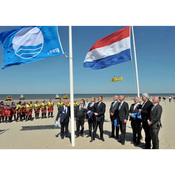
The Blue Flag award is given to beaches and marinas that meet an extensive set of criteria related to quality, safety, environmental education, the provision of services and environmental management; for beaches there are almost 30 different criteria. Locations award it are widely recognised as being of excellent quality, and the award is well known by the public. The award was started in 1987 by the NGO, the Foundation for Environmental Education in Europe (FEEE). Due to global interest, in 2001 the foundation dropped its association to only Europe and became FEE. The foundation is funded by its membership of state governments. In 2015, 4,154 blue flags were flying at beaches, marinas and tourism businesses. The top five nations with blue flags were Spain, Turkey, Greece, France and Italy, all countries with valuable beach tourism industries. Whilst the award can be seen as a micro-reward like the child’s sticker chart, as it has no financial prize attached to it, it is a valuable tool in branding resorts and encouraging tourism and is thereby sought after.
Whilst many understand the blue flag to be a mark of quality and high environmental standards, few would know the extensiveness of the criteria. This may not be a bad thing, if the criteria are robustly written it can lead to wide benefits beyond those assumed by visitors. However if a lack of a blue flag is then taken to be a sign of poor quality this could be problematic. A beautiful, remote beach may have the highest environmental standards and excellent conditions, but due to a lack of other infrastructure such as a beach map, disabled toilet facilities or easy access, the beach would not qualify for the award. It may even be that some locations would qualify, but the administration simply has not happened. If these locations’ lack of blue flags was taken as a negative judgement of them, this would paint a false picture.
← Back to Lexicon
King Willem-Alexander raising the blue flag
Sources: The Foundation for Environmental Education
Sources: The Foundation for Environmental Education
The river has been a source of food since prehistory. They are often a rich source of fish and other edible aquatic life and are a major source of freshwater. The river also provides an easy means of disposing wastewater and other waste. For this reason, human settlement often flourishing in the riverbank area for the convenience of water resources, which led the river to be polluted and became a place associated with an unsanitary condition.
During the industrial revolution, some rivers are heavily polluted from factories, overpopulation, and lack of sanitation. These rivers were then covered with concrete to hide the deteriorating condition of the river and seen as the success of industrialization and modernization of the urban environment.
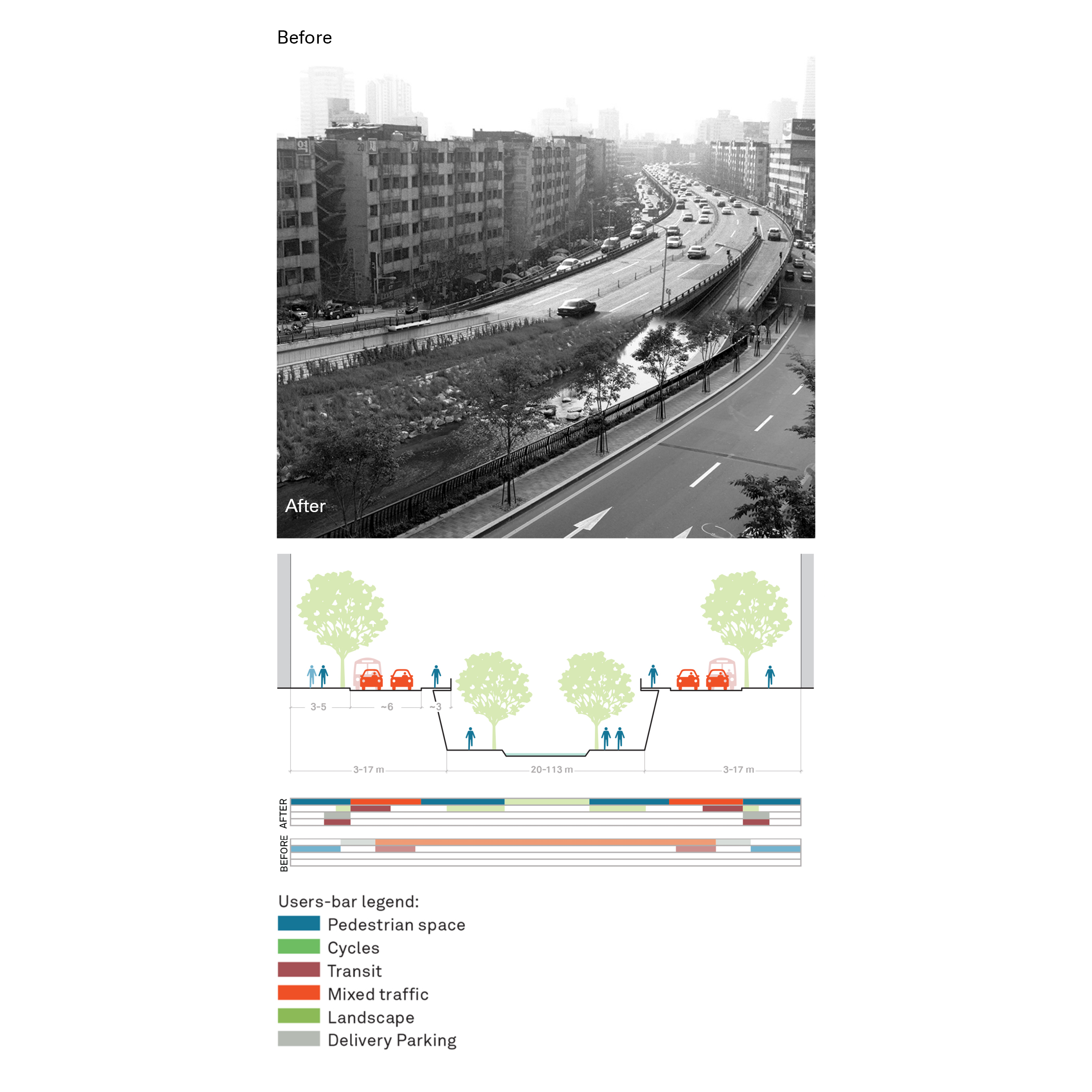
Nowadays, these concrete piped have become a grey space of concrete jungle, which usually used to provide service network for the city, such as road, clean water, sewers, or others. One of the attempts to revitalize this grey space was made by several cities by reverse the process of the piped stream and open the river stream again, called daylighting. Daylighting could bring ecological, economic, and/or socio-cultural wellbeing to the city and its inhabitants, e.g., Restoration of the Cheonggyecheon River in Seoul.
Another example of revitalizing piped stream water is the Ecoducto Linear Park in Mexico City, which aims to show that piped rivers can be reintegrated into the urban water cycle. The linear park runs the length of 1,600 linear meters giving life to new flora, gardens, and fauna. In addition, the project incorporates sludge beds, biodigesters, and water treatment systems, which make it not only an aesthetic element for the city but also a water purifier that gives life to its surroundings.
← Back to Lexicon
Cheonggyecheon restoration project traffic evaluation
Sources: “ Case Study: Cheonggyecheon; Seoul, Korea.” Global Designing Cities Initiative. Accessed May 2, 2021. https://globaldesigningcities.org/publication/global-street-design-guide/streets/special-conditions/elevated-structure-removal/case-study-cheonggyecheon-seoul-korea/.
Sources: “ Case Study: Cheonggyecheon; Seoul, Korea.” Global Designing Cities Initiative. Accessed May 2, 2021. https://globaldesigningcities.org/publication/global-street-design-guide/streets/special-conditions/elevated-structure-removal/case-study-cheonggyecheon-seoul-korea/.
- Daylighting (Streams). Wikipedia. Wikimedia Foundation, April 5, 2021. https://en.wikipedia.org/wiki/Daylighting_(streams).
- Apaloosa Estudio de Arquitectura y Diseño, Simetría Estudio de Arquitectura, and Giancarlo Reyes Olguin. Linear Park Ecoducto: Water as a Constructive Material. urbanNext, October 4, 2019. https://urbannext.net/linear-park-ecoducto/.
- River. Wikipedia. Wikimedia Foundation, May 1, 2021. https://en.wikipedia.org/wiki/River.
- Pollution during the Industrial Revolution. Foundations of Western Culture. Accessed May 2, 2021. https://foundations.uwgb.org/industrial-pollution/.
- Cheonggyecheon. Wikipedia. Wikimedia Foundation, March 21, 2021. https://en.wikipedia.org/wiki/Cheonggyecheon.
A program dedicated to taking on extremely costly clean up projects resulting from past uses.
The Comprehensive Environmental Response, Compensation, and Liabilities Act of 1980 (CERCLA) was passed by the US federal government to investigate and clean up areas that were contaminated with hazardous substances. The Environmental Protection Agency is in charge of this “Superfund” named by the astronomical costs of cleaning up these sites. Out of 40,000 identified sites federally, 1,600 of them are on the National Priorities List that generally require long-term attention called remedial actions. The ones that require short-term attention are referred to as removal actions.
First, the Superfund tries to bring human exposure to these hazardous substances under control by removal of the contamination as well as through monitoring and control of the area use. For example, by implementing groundwater use restrictions. Once the site is under control, the Superfund then tries to open the site back up by bringing new uses there through redevelopment.
In order to achieve this, the Superfund is in charge of finding the potentially responsible parties. Legally, they have established that the seller of a contaminated site is still responsible for the clean up and that this liability is not something that can be passed onto the buyer. In cases where a potentially responsible party cannot be identified, they receive government funds from taxes which until 1995 was applied to oil companies.
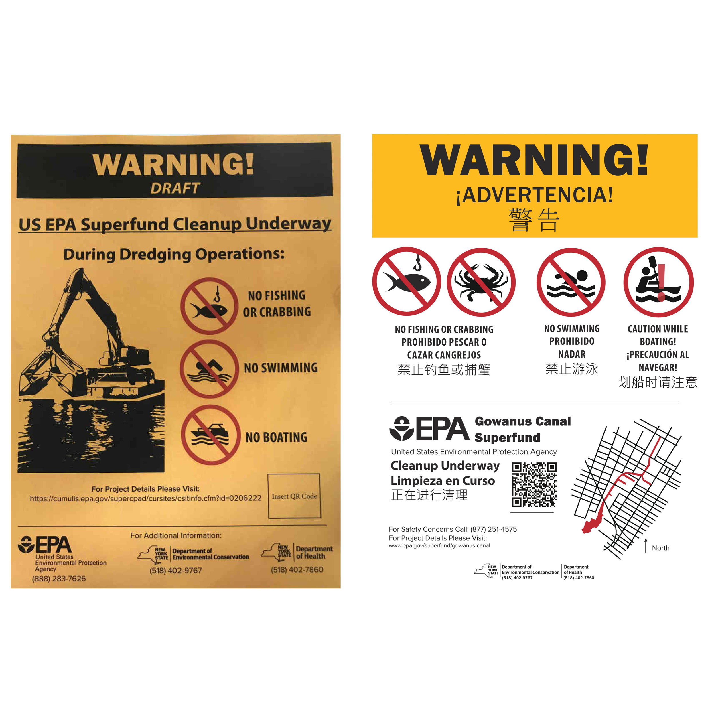
When placing the signs to alert the community around the Gowanus Canal in Brooklyn, NY, of the work being done, the New York State Department of Health was in charge of the project and interfacing with the Gowanus Canal Community Advisory Group. The sign had three drafts before being approved by vote, with one of the changes including a change from “NO BOATING” to “CAUTION WHILE BOATING!” for a group of local recreational canoers.
← Back to Lexicon
Warning sign development with community input for the Gowanus Canal in 2018
Sources: xx
Sources: xx
- https://www.brooklynpaper.com/reel-conundrum-new-signs-ban-fishing-in-toxic-gowanus-but-some-say-they-dont-do-enough-to-discourage-sport/