An aquifer is an underground layer of porous rock, saturated with groundwater. A vital water source, holding precipitation that has infiltrated the soil, with both natural infiltration and artificial injection recharge potential. In Mexico City, which lies in an endorheic basin, over 70% of potable water is derived from the regional aquifer system. At the same time, groundwater is extracted at a faster rate than it can replenish itself, impermeable surfaces are paved over natural recharge areas and agricultural wastewater is withdrawn to the ground when the natural filtration process is not enough to remove all the contaminants.
In the case of Mexico City, the aquifer overexploitation, the urbanization sprawl and the lack of wastewater treatment are leading to subsidence, severe flooding, and eventual water shortage due to groundwater depletion.
Three architectural projects explore the aquifer recharge possibilities throughout Mexico City, reflecting upon site-specific landscapes. By exposing lava strips, manifesting abandoned water parks, and reclaiming volcanic terrains, the contributions build upon the aquifer’s natural and artificial recharge potential, aiming towards a long-term, groundwater capacity balance.
Pedregalore
The volcanic terrain as an aquifer recharge alternative
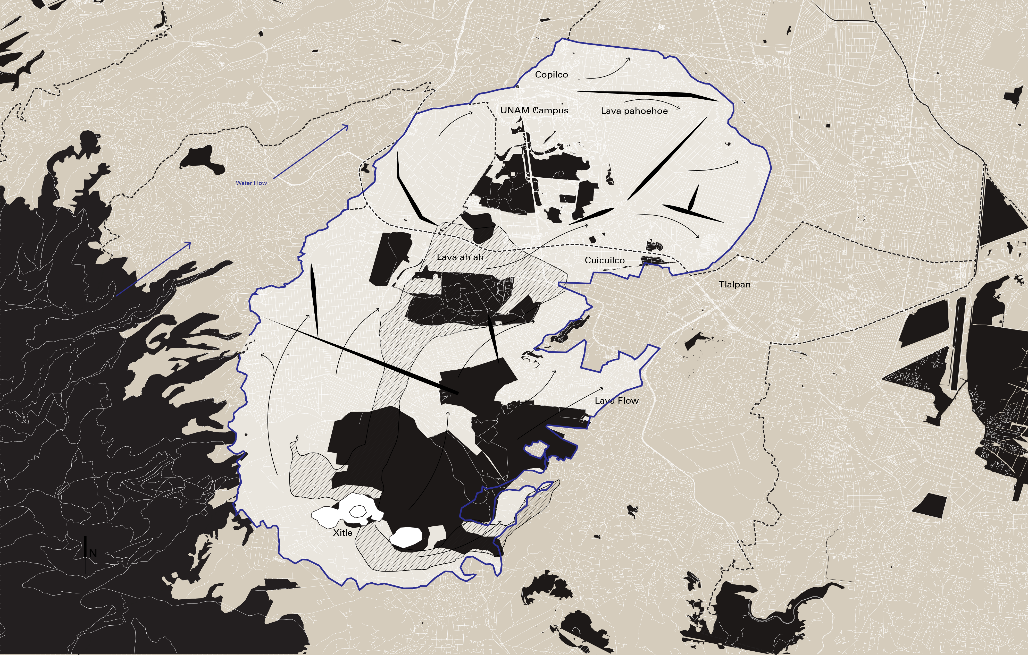
Mexico City is a groundwater-dependent city that faces a ceaseless increase in population. Lying in an endorheic basin, recharge alternatives are essential to balance the sustainability of water supply sources and most importantly the long-term aquifer balance. The traditional practices of desiccation and aquifer exploitation disturbed the performance of the aquifer, causing issues such as subsidence. However, the utilization of the porous volcanic terrain that lies above high compressive clays hides the possibility of changing the underlying groundwater paradigm.
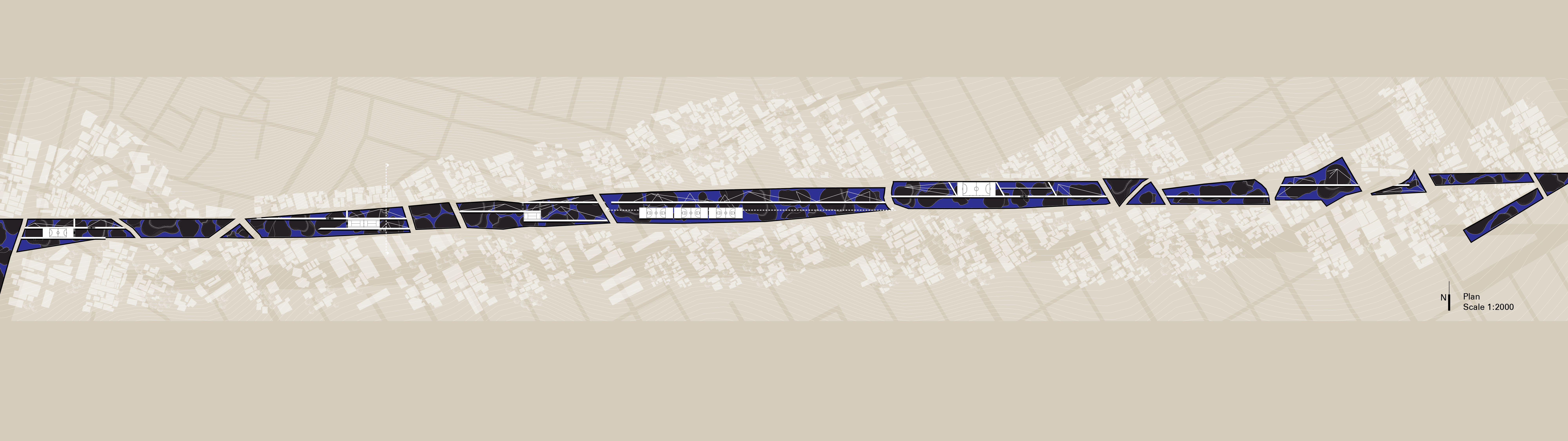
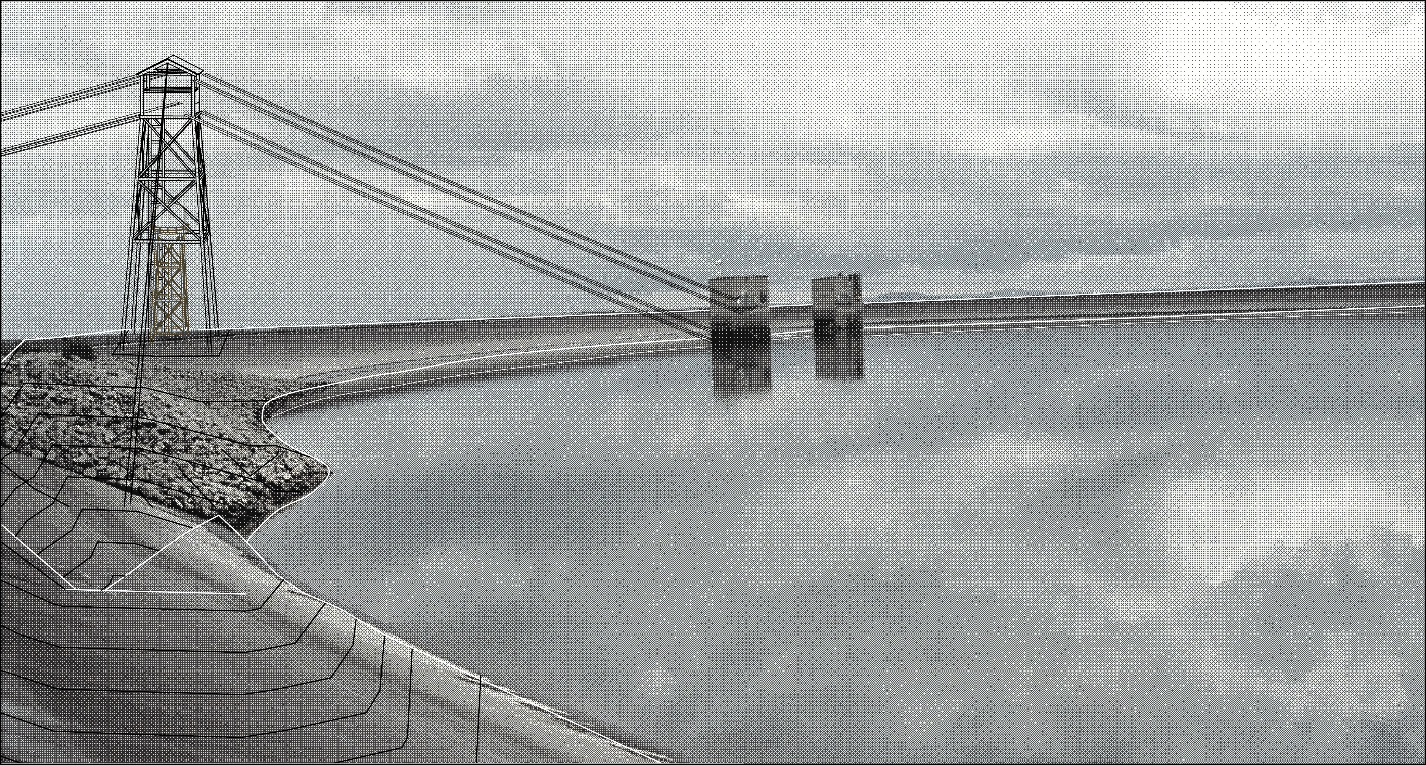
The 80 square kilometer territory that was covered by the lava of the Xitle volcano, known as Pedregal delineates a unique landscape that could be activated as a recharge entry point, allowing the natural infiltration of the water that has stopped by the ongoing expansion of the urban fabric.
The project suggests an alternative to traditional water management, by densifying the public spaces with a systemic perspective.
01 Scar Tissue
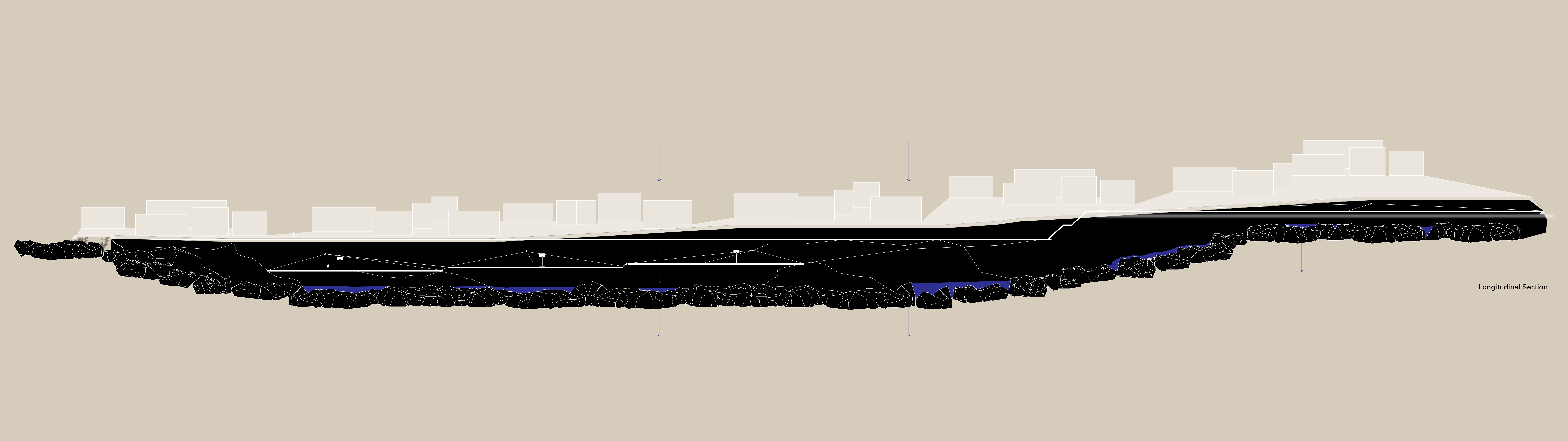
From Luis Barragán's town planning execution in the Pedregal at the beginning of the fifties to today, the unique lava landscape has eroded. Tonnes of concrete and other materials covered the porous soil and blocked every possibility of alternative recharge of the aquifer in the most prominent area. Through the act of extraction in empty in-between public zones, the restoration of the 50s landscape will be accomplished, to suggest a novel recharge alternative that supplements the traditional methods.
02 Water Dike
The height difference from the act of extraction will be solved by the creation of a buffer wall that resembles the dike structure. Part of the extracted material will be reconstructed and reinforced by concrete, not only to support the adjacent existing structures but also to protect the surrounding environment from flooding.
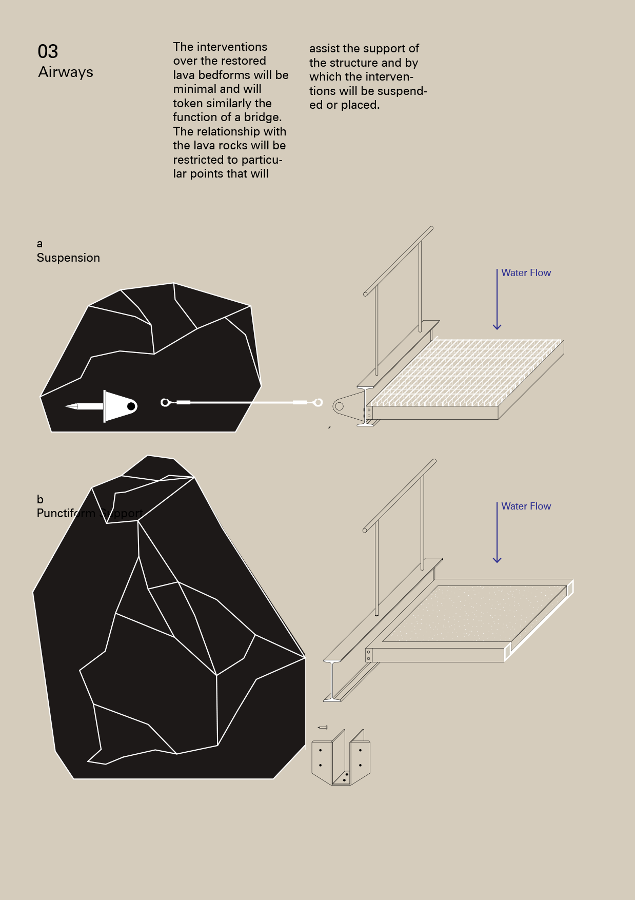
03 Airways
The interventions over the restored lava bedforms will be minimal and will token similarly the function of a bridge. The relationship with the lava rocks will be restricted to particular points that will assist the support of the structure and by which the interventions will be suspended or placed.
The isolated outcrops of black volcanic rock, now, are only remnants of a sublime landscape. The chaotically expanding city deprived its historical geoheritage. The early Barragan's approach to the Pedregal will be revised to create the water gardens, that enable particular "buried" fragments of the lava landscape to be lived publicly.
Contribution by Georgia Katsi
Boca del Cielo
Tthe Recharging Garden
Once upon a time, there was a sea raised from the dry volcanic alluvium landscape in the Third Section of Chapultepec forest. Some bold merchants carried the sand from foothills of the valley and pumped groundwater from 200 meters deep to build this artificial beach that promised citizens an ephemeral escape from the hot days. First inaugurated as Aguas Salvajes, the waterpark successively named as La Ola and El Rollo in the following years before it was shut down and left in oblivion in 2007. It was not until more than a decade later, when a rehabilitation plan of the Third Section was conceived to restore the water system in the drainage basin that this idiosyncratic facility was brought back to the public’s attention again. This project transforms the old waterpark to a civic garden while preserving its spectacularism by placing aquifer recharge equipment in the landscape. The similarity between the megalomaniac formal languages of leisure amenities and water infrastructure reflects on the city’s water metabolism on two levels - first on the Federal District’s current aquifer replenishment program that enhances Chapultepec’s hydrological functionality, then on the historical groundwater overexploitation associated with recreational spaces.
The history of Mexico City’s aquifer replenishment program traces back to the early 1940s, of which primarily focused on alleviating flooding. The Third Section of Chapultepec, with its ravines branching out, retained runoff from upper streams and redirected to the dam of Dolores in the northeast point of the park, where the stormwater then slowly permeated the soil. While the foremost goal in the rehabilitation master plan is to keep the surface water inside the drainage basin as long as possible for infiltration, such a process can still take up to years. As the plan carried out, its role as a water regulating vessel to Mexico City gained increasing importance. Hence, recharging through injection wells becomes a complementary approach. Directly pumping advanced reclaimed water to the aquifer for non-potable use serves as an alternative path of the water cycle, for it bridges wastewater from the adjacent urban sprawl to its aquifer.
This garden can be understood as a non-hierarchical landscape architecture, where the technocratic logic of the groundwater recharge apparatus superimposes on the scenographic spatial structure of an amusement park. Five clusters of injection wells occupy the ground of former water slides, each of which has its own characteristic responding to the form and function of the antecedent slide. While the vibrant purple pipes replace the deteriorated plastic tubes, the pools - now all drained - become niches for visitors to rest. Here, in the center of every niche is where the reclaimed water gets pumped into the aquifer. Through the cool metallic surface of sluices, the ruin of amusement attraction and subtropical highland plants, the Recharge Garden creates a dry landscape with an abundance of water that questions the role of public recreational space in the city’s water cycle.
Waterparks have always been a unique spatial typology in the minds of Mexico City’s residents. From Keiko the famous killer whale to the wave pool in the woods of Chapultepec, the mirage of water spectacularity is directly connected to the city’s prosperity and glory despite building on an unstable water system. Boca del Cielo, the perfect beach envisaged to allure people for a pleasant summer afternoon later to be found out exists in an unexpected place, might be a reflection on such a contradictory situation. By reversing the direction of water flow on its site, the recharing garden is not only a rehabilitation of the city's aquifer, but the resurgence of people’s dream of water amenities.
Contribution by Heng Yu
Ahuízotl Water Works
Sierra de Santa Catarina: Reclaim, Refill, Recharge
Volcanoes that erupted once and then went dormant—or even extinct—have been dominating the Mexico City skyline since time immemorial. Most of these monogenetic volcanoes still have a powerful visual presence, and have been reclaimed by the city, its residents, and private companies in various ways.
Located in the southeast of Mexico City, Sierra de Ahuízotl (or Sierra de Santa Catarina as it is known today) is part of what once formed the peninsula of Iztapalapa, and home to a range of visually striking monogenetic volcanoes, that run the risk of becoming endangered. Sierra de Ahuízotl—one of the most dramatic and controversial elements of Mexico City—is currently a neighborhood park, consisting of an important water conservation zone, a protected natural landscape, and a mining paradise.
Tezontle, the distinctive local red stone that is used in traditional buildings, as well as basalt and sand, used for construction, are mined in the area, causing severe damages and seriously deteriorating the Sierra’s overall body - sometimes up to 70%.
During the rainy season, the rain water run-off from the mountain hill’s, combined with the deterioration of the land due to exploitation is causing severe flooding to the adjoining neighborhood of Iztapalapa. At the same time, the porous material that is constantly being extracted from the area is considered the most efficient soil type to naturally recharge the city’s aquifer, having the ability to absorb and purify water.
This paradox opens up the opportunity for a strategic reclamation plan, once all mining activity is over. Given the specificity of the site, the project is twofold. On the one hand, the already formed cavities and scars on the volcanoes form natural recharge areas, filled with water with minor landscape interventions. Retention ponds, areas for water sources, infiltration terraces, gravity injection wells and wetlands are formed in order to redirect, delay and temporarily retain water within the site.
On the other hand, the volcano chain operates as a well-oiled, water machine, to meet both internal and the surrounding neighborhoods’ needs. For that purpose, infrastructure such as cargo funiculars, water towers, and cableways are added in order to transfer, exploit, and store water.
The project collects rain water from the deepest point of Iztapalapa and relocates it to the Sierra using a funicular system. There, the input is purified and stored to the Xaltepec crater, which, at the same time, operates as a pumped-energy plant to power the funicular machinery. The clean water that reaches the ground is then distributed for residential use. The funicular constantly transfers water buckets throughout the area in order to refill the wetlands and eventually store the water to the large reservoir that also serves as a natural recharger: the crater of mount Tetlaman, the highest point in Iztapalapa.