During the last 150 years, the Danube river in Vienna was reformed by extensive flood-control engineering. The Vienna Danube Regulation describes all the necessary actions to prevent and control flooding.
The first official proposal for regulating the Danube river by the formation of a new river bed, was in 1810 by Josef von Shemerl after recurring severe flooding. However it was never realized. Between 1870 and 1875 the first major dams or levees were built in today’s municipal districts of Florisdorf and Donaustadt, on the left bank of the river, separating from the old river bed, the Old Danube. Between 1972 and 1988, a new channel, the New Danube, created and the material that occurred from its excavation, formed the Danube Island.
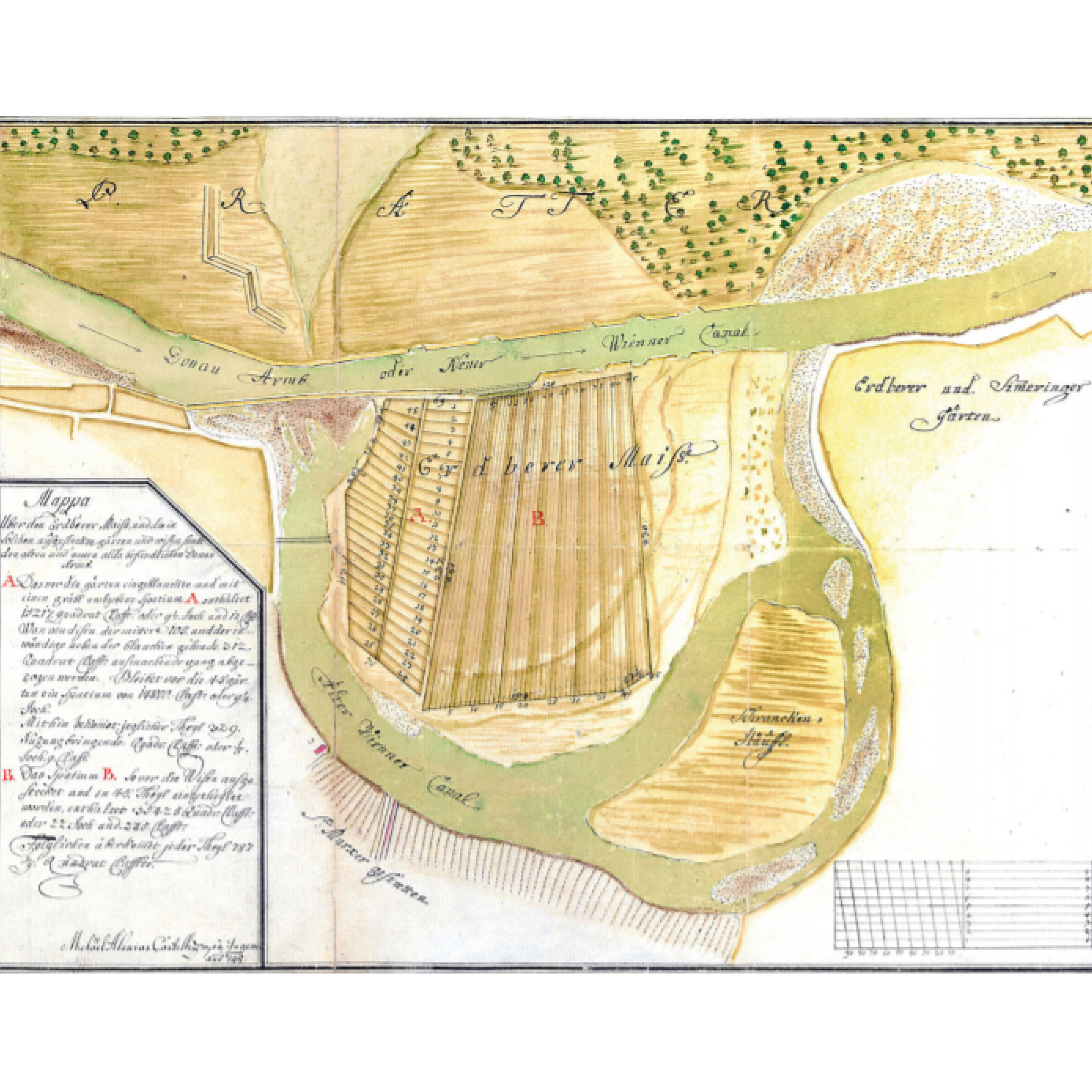
Nevertheless, the unrecorded origins of Donau Regulerum, are found a century earlier in the largest meander loop of Donau Kanal. Erdberger Mais, an area located southeast of Vienna, was formed by the dynamics of Danube, but also by the local regulations on the river landscape. Around 1715, a minor loop was cut off and straighten by means of a puncture, because it was threatening to erode part of the Prater Main Alley by breaking through to the main arm of Danube. In 1926, the large meander around the Mais was cut and dammed, by Emperor Karl VI orders. The design of the dam would allow the floods once per year, by depositing the fine sediments into the old river and protecting the oxbow lake.
The particular land reclamation was one of the earliest hydraulic engineering breakthroughs. The alluvial land, with its nutrient-rich and sandy soils, was well suited for agriculture activities and in particular for planting vegetables and herb gardens. By 1740 the land was parcelled and distributed to vegetable farmers.
Roughly 100 years after its creation, Erdberger Mais, “accounted for about 20 % of acreage for vegetable production in the city and its close environs”, playing a vital role in the city’s food supply. The specific land use and the configuration of the parcels to maintain the land arable, preserved the topographical characteristics. However, after WWII the land was massively transformed, erasing the remains of its hydraulic past.
← Back to Lexicon
The first official proposal for regulating the Danube river by the formation of a new river bed, was in 1810 by Josef von Shemerl after recurring severe flooding. However it was never realized. Between 1870 and 1875 the first major dams or levees were built in today’s municipal districts of Florisdorf and Donaustadt, on the left bank of the river, separating from the old river bed, the Old Danube. Between 1972 and 1988, a new channel, the New Danube, created and the material that occurred from its excavation, formed the Danube Island.
Nevertheless, the unrecorded origins of Donau Regulerum, are found a century earlier in the largest meander loop of Donau Kanal. Erdberger Mais, an area located southeast of Vienna, was formed by the dynamics of Danube, but also by the local regulations on the river landscape. Around 1715, a minor loop was cut off and straighten by means of a puncture, because it was threatening to erode part of the Prater Main Alley by breaking through to the main arm of Danube. In 1926, the large meander around the Mais was cut and dammed, by Emperor Karl VI orders. The design of the dam would allow the floods once per year, by depositing the fine sediments into the old river and protecting the oxbow lake.
The particular land reclamation was one of the earliest hydraulic engineering breakthroughs. The alluvial land, with its nutrient-rich and sandy soils, was well suited for agriculture activities and in particular for planting vegetables and herb gardens. By 1740 the land was parcelled and distributed to vegetable farmers.
Roughly 100 years after its creation, Erdberger Mais, “accounted for about 20 % of acreage for vegetable production in the city and its close environs”, playing a vital role in the city’s food supply. The specific land use and the configuration of the parcels to maintain the land arable, preserved the topographical characteristics. However, after WWII the land was massively transformed, erasing the remains of its hydraulic past.
← Back to Lexicon
A map of Erdberger Mais in 1748 illustrating the parcels of land in the effort to make it arable and the first cut-off of Donau river.
Sources: WStLA, Kartographische Sammlung, P1.42: ‘‘Mappa u¨ber den Erdberger Mais und die in Solchen ausgesteckte ga¨rten und wisen, sambt den alten und neuen alda befindlichen Donau Armbs’’, 1748
Sources: WStLA, Kartographische Sammlung, P1.42: ‘‘Mappa u¨ber den Erdberger Mais und die in Solchen ausgesteckte ga¨rten und wisen, sambt den alten und neuen alda befindlichen Donau Armbs’’, 1748