Legend has it, that -precisely- on May 24, 1065 CE, the Aztecs ventured on an epic migration from their ancestral homeland, Aztlan (“Place of Reeds” or “Place of Egrets”), to the shores of Lake Texcoco, in central Mexico. There, by forming another altépetl, they founded the city of Tenochtitlan, which in time spawned the vast Aztec Empire, famously encountered by Hernan Cortez several hundred years later. The altépetl (plural altepeme) was the local ethnical-political-territorial entity or “city-state” in Mesoamerican societies. The indigenous identity during the Aztec Empire was defined by the altépetl. The word actually combines the Nahuatl word for “water”, ātl, with tepētl, meaning “mountain”, anchoring civilization in a clearly defined territory.1 The Mexican culture and origins are inextricably tied to the elements of earth and water.
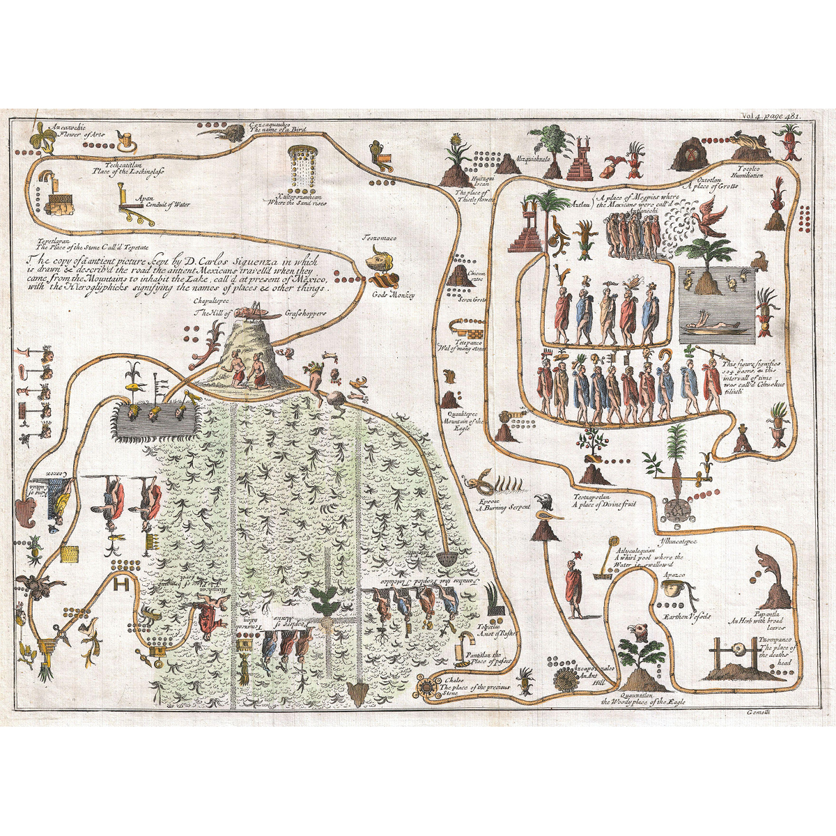
This unusual 1704 map, drawn by Giovanni Francesco Gemelli Careri, is the first published representation of the legendary Aztec migration from Aztlan, a mysterious paradise somewhere to the northwest of Mexico, to Chapultepec Hill. The road that the ancient Mexicans travelled when they came from the mountain on the lake in order to inhabit Lake Texcoco, is drawn and described with the Hieroglyphics signifying the names of content and places. Aztlan appears here in the upper right corner also as a lake, with a mountain and a palm tree. The progression meanders along many paths and digressions to finally arrive to the upper right quadrant, where we can discern a hill upon which rests a gigantic Grasshopper. This is Chapultepec, known nowadays as Mexico City.2
This unusual 1704 map, drawn by Giovanni Francesco Gemelli Careri, is the first published representation of the legendary Aztec migration from Aztlan, a mysterious paradise somewhere to the northwest of Mexico, to Chapultepec Hill. The road that the ancient Mexicans travelled when they came from the mountain on the lake in order to inhabit Lake Texcoco, is drawn and described with the Hieroglyphics signifying the names of content and places. Aztlan appears here in the upper right corner also as a lake, with a mountain and a palm tree. The progression meanders along many paths and digressions to finally arrive to the upper right quadrant, where we can discern a hill upon which rests a gigantic Grasshopper. This is Chapultepec, known nowadays as Mexico City.2
Gemelli Map of the Aztec Migration from Aztlan to Chapultepec.