The Flint water crisis happened between 2014 to 2019. It has a classic three-act structure narrative, which elaborates the status of water as a system in the city and its characteristic in social and spatial strategies.
The first act, the Setup, begins with the end of Flint's automobile-based industry. The Flint River that has a long history of suffering from toxic chemical pollution has now become part of the social and spatial segregation system. In the second and the Confrontation act started with the “inadequate treatment and testing of the water” when the government decided to switch their water supply source from Detroit Water and Sewerage Department to Flint river due to cost-down reasons. The water without application of corrosion inhibitors flowed through sluices made from lead cause severe heavy metal neurotoxin contamination and Legionnaires' disease. Finally, the Resolution, casting a group of computer scientists, told the story of how the city - and event the country - tried to prevent the tragedy of Flint from happening again.
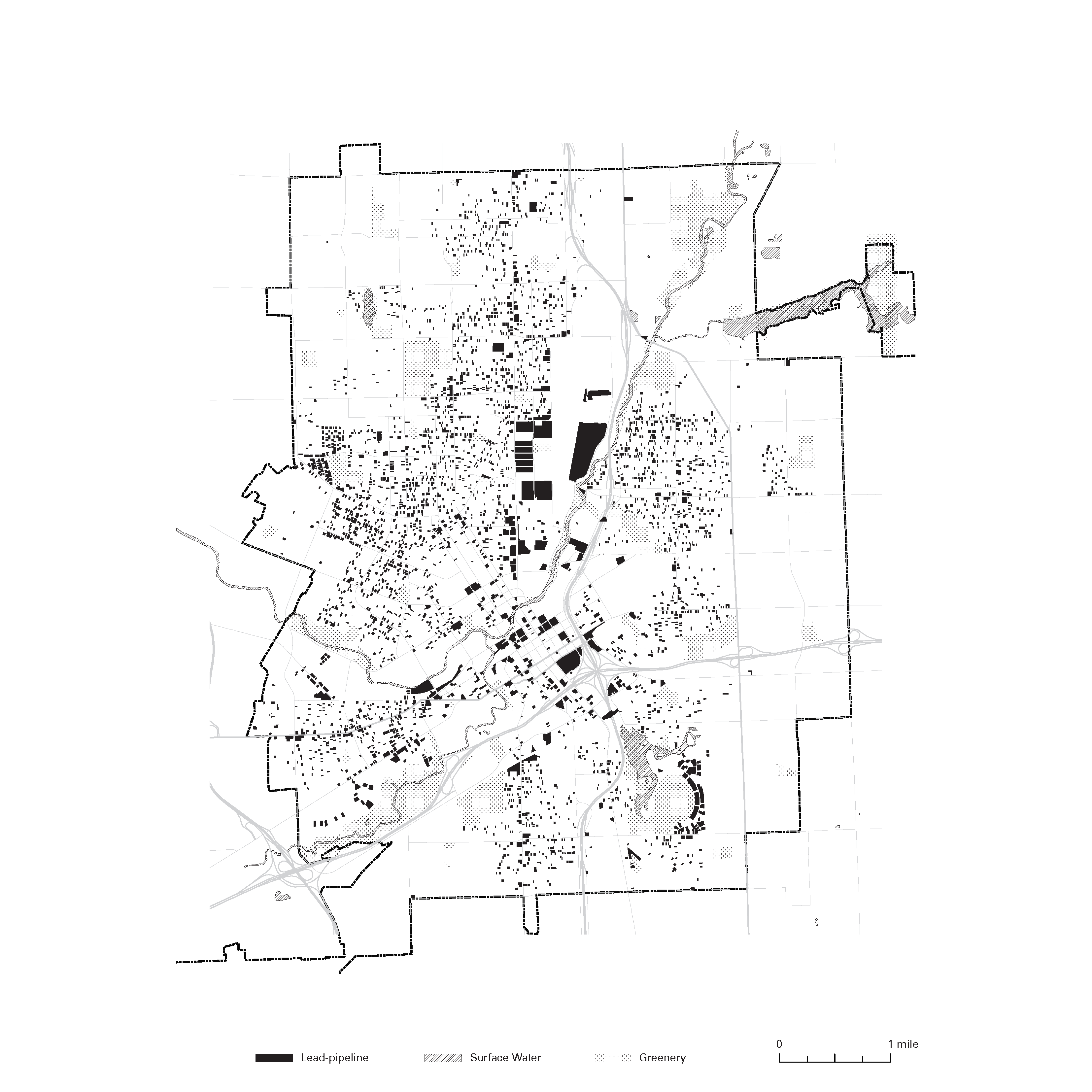
While the municipality putting efforts into replacing lead pipelines, the biggest question emerged: where to dig? Despite the brief understanding of lead-pipe mostly found in postwar homes, the messy city archive where old cadastral map and “cards” of infrastructure connecting parcels made it impossible to identify and clarify the exact deployment of lead-pipes.
← Back to Lexicon
The first act, the Setup, begins with the end of Flint's automobile-based industry. The Flint River that has a long history of suffering from toxic chemical pollution has now become part of the social and spatial segregation system. In the second and the Confrontation act started with the “inadequate treatment and testing of the water” when the government decided to switch their water supply source from Detroit Water and Sewerage Department to Flint river due to cost-down reasons. The water without application of corrosion inhibitors flowed through sluices made from lead cause severe heavy metal neurotoxin contamination and Legionnaires' disease. Finally, the Resolution, casting a group of computer scientists, told the story of how the city - and event the country - tried to prevent the tragedy of Flint from happening again.
While the municipality putting efforts into replacing lead pipelines, the biggest question emerged: where to dig? Despite the brief understanding of lead-pipe mostly found in postwar homes, the messy city archive where old cadastral map and “cards” of infrastructure connecting parcels made it impossible to identify and clarify the exact deployment of lead-pipes.
← Back to Lexicon
Redraw of the 2016 Flint Lead Pipe Mapping Project, showing the spatial distribution of lead-pipeline in the city.
Sources: University of Michigan - Flint. “Map of Flint’s Lead Water Pipe.” 2016. GIS Center, University of Michigan - Flint. https://www.umflint.edu/sites/default/files/groups/GIS_Center/leadconn_11_7.pdf
Sources: University of Michigan - Flint. “Map of Flint’s Lead Water Pipe.” 2016. GIS Center, University of Michigan - Flint. https://www.umflint.edu/sites/default/files/groups/GIS_Center/leadconn_11_7.pdf
Potable Water, WASH, Failure